
FCCInfo.com
A Service of Cavell, Mertz & Associates, Inc.
(855) FCC-INFO
|
|
K279CR from 08/13/2015 K279CR from 03/23/2015 K279CR from 01/08/2014 |
|
|
||||||||||||||||
|
|
K279CR Channel: 279D 103.7 MHz Oklahoma City, Oklahoma Service: FX - A translator or application for a translator. Facility ID: 157276 Fac. Service: FX Programming Delivery Method: Unspecified Status: License Application Accepted: 08/26/2022 Application Granted: 09/22/2022 File Number: -0000198401 License Expires: 06/01/2029 Application Type: License To Cover FCC Website Links: LMS Facility Details This Application Other K279CR Applications Other K279CR Applications in CDBS Including Superseded Applications Mailing Address Correspondence for K279CR Correspondence related to application -0000198401 Service Contour - Open Street Map or USGS Map (60 dBu) Service Contour - KML / Google Earth (60 dBu) Facility Type: FM STATION Class: D, A Noncommercial educational operating with no more than 10W Site Location: 35-33-59.2 N 97-28-29.1 W (NAD 83) Site Location: 35-33-59.0 N 97-28-28.0 W (Converted to NAD 27) Effective Radiated Power: 0.25 kW Transmitter Output Power: 0.1 kW Antenna Center HAAT: 0 m Antenna Center AMSL: 492.9 m (1617 ft.) Antenna Center HAG: 146.3 m (480 ft.) Site Elevation: 346.6 m. (1137 ft.) Height Overall*: 152.1 m (499 ft.) (* As Filed In This Application, may differ from ASR Data, Below.) Directional Antenna Antenna Make/Model: Kathrein CA5-FM/CP/RM Antenna ID: 123268 Polarization: H
| ||||||||||||||||||
| Antenna Data for Antenna Id: 123268 K279CR FX File: -0000198401 Kathrein - CA5-FM/CP/RM Service: FX | 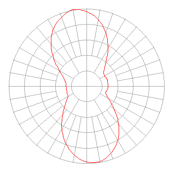 | ||||||||||||||||||
| Azimuth | Ratio | Azimuth | Ratio | Azimuth | Ratio | Azimuth | Ratio | ||||||||||||
| 0 | 0.960 | 10 | 0.872 | 20 | 0.727 | 30 | 0.551 | ||||||||||||
| 40 | 0.381 | 50 | 0.290 | 60 | 0.266 | 70 | 0.278 | ||||||||||||
| 80 | 0.275 | 90 | 0.279 | 100 | 0.271 | 110 | 0.263 | ||||||||||||
| 120 | 0.325 | 130 | 0.460 | 140 | 0.642 | 150 | 0.804 | ||||||||||||
| 160 | 0.923 | 170 | 0.989 | 180 | 0.980 | 190 | 0.904 | ||||||||||||
| 200 | 0.783 | 210 | 0.633 | 220 | 0.474 | 230 | 0.351 | ||||||||||||
| 240 | 0.276 | 250 | 0.266 | 260 | 0.259 | 270 | 0.262 | ||||||||||||
| 280 | 0.272 | 290 | 0.314 | 300 | 0.408 | 310 | 0.548 | ||||||||||||
| 320 | 0.711 | 330 | 0.851 | 340 | 0.944 | 350 | 1.000 | ||||||||||||
Structure Registration Number 1211892 Structure Type: TOWER Registered To: TYLER BROADCASTING CORPORATION Structure Address: 2333 East Britton Road Oklahoma City, OK County Name: Oklahoma County ASR Issued: 06/01/2000 Date Built: 01/01/1973 Site Elevation: 346.6 m (1137 ft.) Structure Height: 151.2 m (496 ft.) Height Overall: 152.1 m (499 ft.) Overall Height AMSL: 498.7 m (1636 ft.) FAA Determination: 05/23/2000 FAA Study #: 00-ASW-1155-OE Paint & Light FAA Chapters: 1, 3, 12, 21 Removed embedded carriage return(s) and extraneous quotation marks./jjs/case#1764417 35-33-59.2 N 97-28-29.1 W (NAD 83) 35-33-59.0 N 97-28-28.0 W (Converted to NAD 27) |
5101 S. Shields Blvd Oklahoma City, OK 73129 Phone: 405-429-5500 Limited Liability Company | Title: Manager Date: 08/26/2022 Application Certifier TYLER MEDIA L.L.C. Tyler Media L.l.c. 5101 S. Shields Blvd Oklahoma City, OK 73129 Applicant George S. Crissey Bromo Communications, Inc. 3600 Dallas Highway Suite 230 - Pmb 164 Marietta, GA 30064 Technical Consultant John C. Trent, Esq Putbrese, Hunsaker And Trent, Pc 200 South Church Street Woodstock, VA 22664 Counsel | |||||||||||||||||