
FCCInfo.com
A Service of Cavell, Mertz & Associates, Inc.
(855) FCC-INFO
|
|
K295DB from 05/19/2023 K294CV from 02/08/2016 K294CV from 08/20/2008 K294CV from 10/24/2003 K294CV from 11/14/1997 |
|
|
||||||||||||||||
|
|
K295DB Channel: 295D 106.9 MHz Bend, Oregon Service: FX - A translator or application for a translator. Facility ID: 89202 Fac. Service: FX Programming Delivery Method: Unspecified Status: License Application Accepted: 09/08/2022 Application Granted: 05/19/2023 File Number: -0000199572 License Expires: 02/01/2030 Application Type: License To Cover FCC Website Links: LMS Facility Details This Application Other K295DB Applications Other K295DB Applications in CDBS Including Superseded Applications Mailing Address Correspondence for K295DB Correspondence related to application -0000199572 Service Contour - Open Street Map or USGS Map (60 dBu) Service Contour - KML / Google Earth (60 dBu) Facility Type: NON-COMMERCIAL EDUC. FM Class: D, A Noncommercial educational operating with no more than 10W Site Location: 44-11-50.8 N 120-58-40.5 W (NAD 83) Site Location: 44-11-51.4 N 120-58-36.4 W (Converted to NAD 27) Effective Radiated Power: 0 kW Horiz. ; 0.25 kW Vert. Antenna Center HAAT: 0 m Antenna Center AMSL: 0 m Horiz.; 1601.3 m Vert. Antenna Center HAG: 0 m Horiz.; 24 m Vert. Site Elevation: 1577.3 m. (5175 ft.) Height Overall*: 48.7 m (160 ft.) (* As Filed In This Application, may differ from ASR Data, Below.) Directional Antenna Antenna Make/Model: SCALA FMV Antenna ID: 0 Polarization: H
| ||||||||||||||||||
| Antenna Data for Antenna Id: 0 K295DB FX File: -0000199572 SCALA - FMV Service: FX | 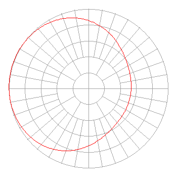 | ||||||||||||||||||
| Azimuth | Ratio | Azimuth | Ratio | Azimuth | Ratio | Azimuth | Ratio | ||||||||||||
| 0 | 0.854 | 10 | 0.802 | 20 | 0.746 | 30 | 0.690 | ||||||||||||
| 40 | 0.639 | 50 | 0.599 | 60 | 0.571 | 70 | 0.552 | ||||||||||||
| 80 | 0.541 | 90 | 0.536 | 100 | 0.534 | 110 | 0.534 | ||||||||||||
| 120 | 0.539 | 130 | 0.547 | 140 | 0.562 | 150 | 0.586 | ||||||||||||
| 160 | 0.622 | 170 | 0.669 | 180 | 0.723 | 190 | 0.780 | ||||||||||||
| 200 | 0.834 | 210 | 0.882 | 220 | 0.921 | 230 | 0.950 | ||||||||||||
| 240 | 0.971 | 250 | 0.984 | 260 | 0.993 | 270 | 0.998 | ||||||||||||
| 280 | 0.999 | 290 | 0.999 | 300 | 0.995 | 310 | 0.988 | ||||||||||||
| 320 | 0.977 | 330 | 0.959 | 340 | 0.934 | 350 | 0.899 | ||||||||||||
Structure Registration Number 1267995 Structure Type: TOWER Registered To: Day Management Corp. dba Day Wireless Systems Structure Address: Powell Butte, Oregon Prineville, OR County Name: Crook County ASR Issued: 04/17/2009 Date Built: 04/17/2009 Site Elevation: 1577.3 m (5175 ft.) Structure Height: 45.7 m (150 ft.) Height Overall: 48.7 m (160 ft.) Overall Height AMSL: 1626 m (5335 ft.) FAA Determination: 02/27/2009 FAA Study #: 2008-ANM-3350-OE Paint & Light FAA Chapters: NONE Removed expiration date from determination. Scenario 1./jjs/case#635066 44-11-50.8 N 120-58-40.5 W (NAD 83) 44-11-51.4 N 120-58-36.4 W (Converted to NAD 27) |
4002 N. 3300 E. Twin Falls, ID 83303 Phone: 208-733-3133 Private Not-for-Profit Educational Institution | Title: President Date: 09/08/2022 Application Certifier CSN INTERNATIONAL Csn International 4002 N. 3300 E. Twin Falls, ID 83303 Applicant SCOTT SPENCER Csn International 4002 N. 3300 E. Twin Falls, ID 83301 TECHNICAL REPRESENTATIVE CARY TEPPER Tepper Law Firm, Llc 4900 Auburn Ave. Suite 100 Bethesda, MD 20814 LEGAL REPRESENTATIVE | |||||||||||||||||