
FCCInfo.com
A Service of Cavell, Mertz & Associates, Inc.
(855) FCC-INFO
|
|
|
|
|
||||||||||||||||
|
|
KCYS-FM1 Channel: 243A 96.5 MHz Astoria, Oregon Service: FB - A booster station or application for a booster. Facility ID: 776450 Fac. Service: FB Programming Delivery Method: Unspecified Status: License Application Accepted: 10/26/2022 Application Granted: 11/02/2022 File Number: -0000202911 License Expires: 02/01/2030 Application Type: License To Cover FCC Website Links: LMS Facility Details This Application Other KCYS-FM1 Applications Other KCYS-FM1 Applications in CDBS Including Superseded Applications Mailing Address Correspondence for KCYS-FM1 Correspondence related to application -0000202911 Service Contour - Open Street Map or USGS Map (60 dBu) Service Contour - KML / Google Earth (60 dBu) Facility Type: FM STATION Class: A, A Zone I; I-A; or II station; with 0.1kW-6kW ERP and a class contour distance <=28km Site Location: 46-11-15.2 N 123-50-20.6 W (NAD 83) Site Location: 46-11-15.8 N 123-50-16.1 W (Converted to NAD 27) Effective Radiated Power: 0.099 kW Horiz. ; 0 kW Vert. Antenna Center HAAT: 0 m Antenna Center AMSL: 74.3 m Horiz.; 0 m Vert. Antenna Center HAG: 7.5 m Horiz.; 0 m Vert. Site Elevation: 66.8 m. (219 ft.) Height Overall*: 7.6 m (25 ft.) (* As Filed In This Application, may differ from ASR Data, Below.) Directional Antenna Antenna Make/Model: SAM 2XSAM-137; 70&300 Antenna ID: 1010055 Polarization: H
| ||||||||||||||||||
| Antenna Data for Antenna Id: 1010055 KCYS-FM1 FB File: -0000202911 SAM - 2XSAM-137; 70&300 Service: FB | 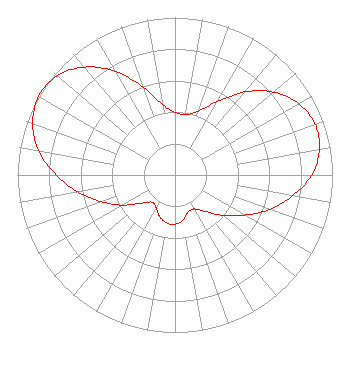 | ||||||||||||||||||
| Azimuth | Ratio | Azimuth | Ratio | Azimuth | Ratio | Azimuth | Ratio | ||||||||||||
| 0 | 0.398 | 10 | 0.391 | 20 | 0.430 | 30 | 0.536 | ||||||||||||
| 40 | 0.688 | 50 | 0.819 | 60 | 0.907 | 70 | 0.946 | ||||||||||||
| 80 | 0.932 | 90 | 0.868 | 100 | 0.758 | 110 | 0.639 | ||||||||||||
| 120 | 0.509 | 130 | 0.399 | 140 | 0.303 | 150 | 0.249 | ||||||||||||
| 160 | 0.249 | 170 | 0.292 | 180 | 0.313 | 190 | 0.309 | ||||||||||||
| 200 | 0.282 | 210 | 0.240 | 220 | 0.225 | 230 | 0.279 | ||||||||||||
| 240 | 0.382 | 250 | 0.496 | 260 | 0.625 | 270 | 0.755 | ||||||||||||
| 280 | 0.878 | 290 | 0.962 | 300 | 1.000 | 310 | 0.978 | ||||||||||||
| 320 | 0.895 | 330 | 0.760 | 340 | 0.594 | 350 | 0.453 | ||||||||||||
Structure Registration Number 1318425 Structure Type: LTOWER Structure Address: 390 Franklin Ave Astoria, OR County Name: Clatsop County ASR Issued: 02/11/2021 Date Built: 06/01/1991 Site Elevation: 66.8 m (219 ft.) Structure Height: 7.6 m (25 ft.) Height Overall: 7.6 m (25 ft.) Overall Height AMSL: 74.4 m (244 ft.) FAA Determination: 02/08/2021 FAA Study #: 2021-ANM-87-OE Paint & Light FAA Chapters: NONE 46-11-15.2 N 123-50-20.6 W (NAD 83) 46-11-15.8 N 123-50-16.1 W (Converted to NAD 27) |
2617 W. Falls Avenue Kennewick, WA 99336 Phone: 509-737-8762 Limited Liability Company | Title: President Date: 10/26/2022 Application Certifier Jacobs Radio Programming Jacobs Radio Programming, Llc 2617 W. Falls Avenue Kennewick, WA 99336 Applicant Jeffrey Huffman Jacobs Radio Programming, Llc 2617 W. Falls Avenue Kennewick, WA 99336 President ERIK C SWANSON, PE Hatfield & Dawson Hatfield & Dawson Consulting Engineers 9500 Greenwood Avenue N Seattle, WA 98103 CONSULTING ENGINEER | |||||||||||||||||