
FCCInfo.com
A Service of Cavell, Mertz & Associates, Inc.
(855) FCC-INFO
|
|
W258AE from 01/12/1994 |
|
|
||||||||||||||||
|
|
W258AE Channel: 258D 99.5 MHz Florence, Alabama Service: FX - A translator or application for a translator. Facility ID: 58436 Fac. Service: FX Programming Delivery Method: Unspecified Status: License Application Accepted: 01/10/2023 Application Granted: 01/17/2023 File Number: -0000206631 License Expires: 04/01/2028 Application Type: License To Cover FCC Website Links: LMS Facility Details This Application Other W258AE Applications Other W258AE Applications in CDBS Including Superseded Applications Mailing Address Correspondence for W258AE Correspondence related to application -0000206631 Service Contour - Open Street Map or USGS Map (60 dBu) Service Contour - KML / Google Earth (60 dBu) Facility Type: NON-COMMERCIAL EDUC. FM Class: D, A Noncommercial educational operating with no more than 10W Site Location: 34-45-23.6 N 87-40-43.6 W (NAD 83) Site Location: 34-45-23.3 N 87-40-43.5 W (Converted to NAD 27) Effective Radiated Power: 0.01 kW Transmitter Output Power: 0.08 kW Antenna Center HAAT: 73.4 m Horiz.; 0 m Vert. Antenna Center AMSL: 260.5 m Horiz.; 0 m Vert. Antenna Center HAG: 105 m Horiz.; 0 m Vert. Site Elevation: 155.5 m. (510 ft.) Height Overall*: 106.4 m (349 ft.) (* As Filed In This Application, may differ from ASR Data, Below.) Directional Antenna Antenna Make/Model: Nicom BKG77 Antenna ID: 1005767 Polarization: H
| ||||||||||||||||||
| Antenna Data for Antenna Id: 1005767 W258AE FX File: -0000206631 Nicom - BKG77 Service: FX | 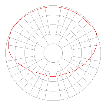 | ||||||||||||||||||
| Azimuth | Ratio | Azimuth | Ratio | Azimuth | Ratio | Azimuth | Ratio | ||||||||||||
| 0 | 0.966 | 10 | 0.966 | 20 | 0.966 | 30 | 0.966 | ||||||||||||
| 40 | 0.966 | 50 | 0.966 | 60 | 1.000 | 70 | 0.982 | ||||||||||||
| 80 | 0.927 | 90 | 0.852 | 100 | 0.762 | 110 | 0.692 | ||||||||||||
| 120 | 0.627 | 130 | 0.581 | 140 | 0.536 | 150 | 0.504 | ||||||||||||
| 160 | 0.493 | 170 | 0.493 | 180 | 0.493 | 190 | 0.493 | ||||||||||||
| 200 | 0.493 | 210 | 0.507 | 220 | 0.536 | 230 | 0.596 | ||||||||||||
| 240 | 0.643 | 250 | 0.728 | 260 | 0.826 | 270 | 0.908 | ||||||||||||
| 280 | 0.947 | 290 | 0.966 | 300 | 1.000 | 310 | 0.984 | ||||||||||||
| 320 | 0.976 | 330 | 0.966 | 340 | 0.966 | 350 | 0.966 | ||||||||||||
Structure Registration Number 1299445 Structure Type: GTOWER Structure Address: Appx. 300 Ft.south Of End Of Johnson St., . Muscle Shoals, AL County Name: Colbert County ASR Issued: 06/02/2016 Date Built: 03/21/2017 Site Elevation: 155.5 m (510 ft.) Structure Height: 106.4 m (349 ft.) Height Overall: 106.4 m (349 ft.) Overall Height AMSL: 261.9 m (859 ft.) FAA Determination: 08/14/2015 FAA Study #: 2015-ASO-9602-OE FAA Circular #: 70/7460-1K Paint & Light FAA Chapters: 4, 6, 12 Removed expiration date from determination. Scenario 1./jjs/case#635066 34-45-23.6 N 87-40-43.6 W (NAD 83) 34-45-23.3 N 87-40-43.5 W (Converted to NAD 27) |
1722 Treble Drive Humble, TX 77338 Phone: 214-353-9293 Not-for-Profit | Title: Chief Of Media Operations Date: 01/10/2023 Application Certifier Hope Media Group 1722 Treble Drive Humble, TX 77338 Applicant Davina Sashkin, Esq Wilkinson Barker Knauer, Llp 1800 M Street, Nw Suite 800n Washington, DC 20036 Jim Turvaville Turbo Tech Services 360 Patton Street - Po Box 144 Mobeetie, TX 79061 | |||||||||||||||||