
FCCInfo.com
A Service of Cavell, Mertz & Associates, Inc.
(855) FCC-INFO
|
|
|
|
|
||||||||||||||||
|
|
WVLO Channel: 257A 99.3 MHz Cridersville, Ohio Service: FM - A full-service FM station or application. Facility ID: 190376 Fac. Service: FM Status: License 73.215 Station Application Accepted: 03/07/2023 Application Granted: 03/08/2023 File Number: -0000212183 License Expires: 10/01/2028 Application Type: Minor Modification FCC Website Links: LMS Facility Details This Application Other WVLO Applications Other WVLO Applications in CDBS Including Superseded Applications Mailing Address Correspondence for WVLO Correspondence related to application -0000212183 Service Contour - Open Street Map or USGS Map (60 dBu) Service Contour - KML / Google Earth (60 dBu) Public Inspection Files Facility Type: NON-COMMERCIAL EDUC. FM Class: A, A Zone I; I-A; or II station; with 0.1kW-6kW ERP and a class contour distance <=28km Site Location: 40-39-49.6 N 84-05-09.1 W (NAD 83) Site Location: 40-39-49.4 N 84-05-09.3 W (Converted to NAD 27) Effective Radiated Power: 4.5 kW Transmitter Output Power: 1.794 kW Antenna Center HAAT: 116 m (381 ft.) Antenna Center AMSL: 392 m (1286 ft.) Antenna Center HAG: 102 m (335 ft.) Calculated Site Elevation: 290 m. (951 ft.) Height Overall*: 152 m (499 ft.) (* As Filed In This Application, may differ from ASR Data, Below.) Directional Antenna Antenna Make/Model: Shively 6810-3R-SS-DA Antenna ID: 127030 Polarization: | ||||||||||||||||||
| Antenna Data for Antenna Id: 127030 WVLO FM File: -0000212183 Shively - 6810-3R-SS-DA Service: FM | 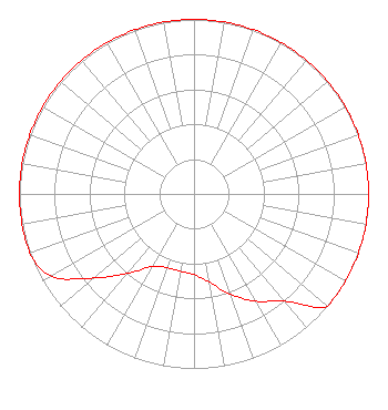 | ||||||||||||||||||
| Azimuth | Ratio | Azimuth | Ratio | Azimuth | Ratio | Azimuth | Ratio | ||||||||||||
| 0 | 1.000 | 10 | 1.000 | 20 | 1.000 | 30 | 1.000 | ||||||||||||
| 40 | 1.000 | 50 | 1.000 | 60 | 1.000 | 70 | 1.000 | ||||||||||||
| 80 | 1.000 | 90 | 1.000 | 100 | 1.000 | 110 | 1.000 | ||||||||||||
| 120 | 1.000 | 130 | 1.000 | 140 | 0.802 | 150 | 0.711 | ||||||||||||
| 160 | 0.611 | 170 | 0.514 | 180 | 0.463 | 190 | 0.450 | ||||||||||||
| 200 | 0.450 | 210 | 0.480 | 220 | 0.595 | 230 | 0.749 | ||||||||||||
| 240 | 0.943 | 250 | 1.000 | 260 | 1.000 | 270 | 1.000 | ||||||||||||
| 280 | 1.000 | 290 | 1.000 | 300 | 1.000 | 310 | 1.000 | ||||||||||||
| 320 | 1.000 | 330 | 1.000 | 340 | 1.000 | 350 | 1.000 | ||||||||||||
Structure Registration Number 1011941 Structure Type: GTOWER Registered To: Vertical Bridge CC FM, LLC Structure Address: 1140 Hume Rd / Us-oh-5070 Lima, OH County Name: Allen County ASR Issued: 04/23/2018 Date Built: 08/21/2002 Site Elevation: 290.2 m (952 ft.) Structure Height: 151.4 m (497 ft.) Height Overall: 152.4 m (500 ft.) Overall Height AMSL: 442.6 m (1452 ft.) FAA Determination: 03/22/2018 FAA Study #: 2018-AGL-3268-OE FAA Circular #: 70/7460-1J Paint & Light FAA Chapters: 4, 6, 13 OM&L to remain the same as prior study = 24-HR MED-STROBES 40-39-49.6 N 84-05-09.1 W (NAD 83) 40-39-49.4 N 84-05-09.3 W (Converted to NAD 27) |
5700 West Oaks Blvd Rocklin, CA 95765 Phone: 916-251-1600 Not-for-Profit | Title: Ceo Date: 03/07/2023 Application Certifier EDUCATIONAL MEDIA FOUNDATION Educational Media Foundation 5700 West Oaks Blvd Rocklin, CA 95765 Applicant MARY O'CONNOR Wilkinson Barker Knauer, Llp 1800 M. Street, N.w., Suite 800n Washington, DC 20036 JAMES L TRAVIS Educational Media Foundation 5700 West Oaks Blvd Rocklin, CA 95765 FCC COMPLIANCE ENGINEER | |||||||||||||||||