
FCCInfo.com
A Service of Cavell, Mertz & Associates, Inc.
(855) FCC-INFO
|
|
|
|
|
||||||||||||||||
|
|
WWJL Channel: 215C2 90.9 MHz Cochran, Georgia Service: FM - A full-service FM station or application. Facility ID: 766584 Fac. Service: FM Status: Construction Permit Application Accepted: 03/13/2023 Application Granted: 04/13/2023 File Number: -0000212434 WWJL CP Expires: 04/08/2025 Application Type: Minor Modification FCC Website Links: LMS Facility Details This Application Other WWJL Applications Other WWJL Applications in CDBS Including Superseded Applications Mailing Address Correspondence for WWJL Correspondence related to application -0000212434 Service Contour - Open Street Map or USGS Map (60 dBu) Service Contour - KML / Google Earth (60 dBu) Public Inspection Files Facility Type: NON-COMMERCIAL EDUC. FM Class: C2, A Zone II station; with 25kW-50kW ERP and a class contour distance 39km-52km Site Location: 32-15-55.0 N 83-20-21.0 W (NAD 83) Site Location: 32-15-54.4 N 83-20-21.4 W (Converted to NAD 27) Effective Radiated Power: 8.5 kW Antenna Center HAAT: 209 m (686 ft.) Antenna Center AMSL: 299 m (981 ft.) Antenna Center HAG: 182 m (597 ft.) Site Elevation: 117 m. (384 ft.) Height Overall*: 191 m (627 ft.) (* As Filed In This Application, may differ from ASR Data, Below.) Directional Antenna Antenna Make/Model: None Antenna ID: 1006063 Polarization: | ||||||||||||||||||
| Antenna Data for Antenna Id: 1006063 WWJL FM File: -0000212434 None - Service: FM | 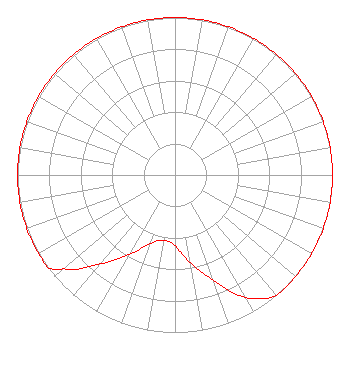 | ||||||||||||||||||
| Azimuth | Ratio | Azimuth | Ratio | Azimuth | Ratio | Azimuth | Ratio | ||||||||||||
| 0 | 1.000 | 10 | 1.000 | 20 | 1.000 | 30 | 1.000 | ||||||||||||
| 40 | 1.000 | 50 | 1.000 | 60 | 1.000 | 70 | 1.000 | ||||||||||||
| 80 | 1.000 | 90 | 1.000 | 100 | 1.000 | 110 | 1.000 | ||||||||||||
| 120 | 1.000 | 130 | 1.000 | 135 | 1.000 | 140 | 1.000 | ||||||||||||
| 150 | 0.898 | 160 | 0.713 | 170 | 0.567 | 180 | 0.450 | ||||||||||||
| 190 | 0.420 | 200 | 0.465 | 210 | 0.585 | 220 | 0.737 | ||||||||||||
| 230 | 0.928 | 234 | 1.000 | 240 | 1.000 | 250 | 1.000 | ||||||||||||
| 260 | 1.000 | 270 | 1.000 | 280 | 1.000 | 290 | 1.000 | ||||||||||||
| 300 | 1.000 | 310 | 1.000 | 320 | 1.000 | 330 | 1.000 | ||||||||||||
| 340 | 1.000 | 350 | 1.000 | ||||||||||||||||
Structure Registration Number 1019539 [ASR Heights Differ from WWJL Application] Structure Type: TOWER Registered To: Pinnacle Towers LLC Structure Address: Cr 110 Eastman, GA County Name: Dodge County ASR Issued: 05/06/2016 Date Built: 09/01/1993 Site Elevation: 116.7 m (383 ft.) Structure Height: 182.9 m (600 ft.) Height Overall: 190.5 m (625 ft.) Overall Height AMSL: 307.2 m (1008 ft.) FAA Determination: 08/11/2009 FAA Study #: 2009-ASO-4222-OE FAA Circular #: 70/7460-1J Paint & Light FAA Chapters: 4, 6, 13 PRIOR STUDY 1997-ASO-4262-OE 32-15-54.7 N 83-20-21.1 W (NAD 83) 32-15-54.1 N 83-20-21.5 W (Converted to NAD 27) |
Pob 23 Margaret, AL 35112 Phone: 205-530-3545 Not-for-Profit | Title: President Of Elijah Radio Date: 03/13/2023 Application Certifier Elijah Radio Elijah Radio, Inc. Pob 23 Margaret, AL 35112 Applicant DONALD MARTIN Law Office Of Donald E. Martin Broadcast & Media Law Falls Church, VA 22041 Attorney LUKE ROGERS Luke Rogers Consulting 1435 Woodland Ridge Road Odenville, AL 35120 | |||||||||||||||||