
FCCInfo.com
A Service of Cavell, Mertz & Associates, Inc.
(855) FCC-INFO
|
|
|
|
|
||||||||||||||||
|
|
WGJL Channel: 220C3 91.9 MHz Milledgeville, Georgia Service: FM - A full-service FM station or application. Facility ID: 766557 Fac. Service: FM Status: Construction Permit 73.215 Station Application Accepted: 04/14/2023 Application Granted: 04/14/2023 File Number: -0000212433 WGJL CP Expires: 09/02/2025 Application Type: Minor Amendment FCC Website Links: LMS Facility Details This Application Other WGJL Applications Other WGJL Applications in CDBS Including Superseded Applications Mailing Address Correspondence for WGJL Correspondence related to application -0000212433 Service Contour - Open Street Map or USGS Map (60 dBu) Service Contour - KML / Google Earth (60 dBu) Public Inspection Files Facility Type: NON-COMMERCIAL EDUC. FM Class: C3, A Zone II station; with 6kW-25kW ERP and a class contour distance 28km-39km Site Location: 32-49-28.7 N 83-10-34.2 W (NAD 83) Site Location: 32-49-28.2 N 83-10-34.6 W (Converted to NAD 27) Effective Radiated Power: 13 kW Antenna Center HAAT: 142 m (466 ft.) Antenna Center AMSL: 242 m (794 ft.) Antenna Center HAG: 105 m (344 ft.) Site Elevation: 137 m. (449 ft.) Height Overall*: 125.3 m (411 ft.) (* As Filed In This Application, may differ from ASR Data, Below.) Directional Antenna Antenna Make/Model: None Antenna ID: 1006063 Polarization: | ||||||||||||||||||
| Antenna Data for Antenna Id: 1006063 WGJL FM File: -0000212433 None - Service: FM | 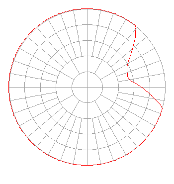 | ||||||||||||||||||
| Azimuth | Ratio | Azimuth | Ratio | Azimuth | Ratio | Azimuth | Ratio | ||||||||||||
| 0 | 1.000 | 10 | 1.000 | 20 | 1.000 | 30 | 1.000 | ||||||||||||
| 38 | 1.000 | 40 | 0.956 | 50 | 0.759 | 60 | 0.603 | ||||||||||||
| 70 | 0.547 | 80 | 0.550 | 90 | 0.692 | 100 | 0.872 | ||||||||||||
| 106 | 1.000 | 110 | 1.000 | 120 | 1.000 | 130 | 1.000 | ||||||||||||
| 140 | 1.000 | 150 | 1.000 | 160 | 1.000 | 170 | 1.000 | ||||||||||||
| 180 | 1.000 | 190 | 1.000 | 200 | 1.000 | 210 | 1.000 | ||||||||||||
| 220 | 1.000 | 230 | 1.000 | 240 | 1.000 | 250 | 1.000 | ||||||||||||
| 260 | 1.000 | 270 | 1.000 | 280 | 1.000 | 290 | 1.000 | ||||||||||||
| 300 | 1.000 | 310 | 1.000 | 320 | 1.000 | 330 | 1.000 | ||||||||||||
| 340 | 1.000 | 350 | 1.000 | ||||||||||||||||
Structure Registration Number 1020278 Structure Type: GTOWER Registered To: AT&T Mobility Spectrum LLC Structure Address: 225 East Main Street (irwinton - Ga Rsa 7b2) 100027314 Irwinton, GA County Name: Wilkinson County ASR Issued: 11/01/2022 Date Built: 03/29/2000 Site Elevation: 137 m (449 ft.) Structure Height: 124.4 m (408 ft.) Height Overall: 125.3 m (411 ft.) Overall Height AMSL: 262.3 m (861 ft.) FAA Determination: 06/03/2008 FAA Study #: 2008-ASO-1642-OE Paint & Light FAA Chapters: A2, H, 3, 4, 13, 21, 23 Continue As Is OM&L = A MED-DUAL SYSTEM 32-49-28.7 N 83-10-34.2 W (NAD 83) 32-49-28.2 N 83-10-34.6 W (Converted to NAD 27) |
Pob 23 Margaret, AL 35112 Phone: 205-530-3545 Not-for-Profit | Title: President Of Elijah Radio Date: 04/14/2023 Application Certifier Elijah Radio, Inc. Pob 23 Margaret, AL 35112 Applicant LUKE ROGERS Luke Rogers Consulting 1435 Woodland Ridge Road Odenville, AL 35120 DONALD MARTIN Law Office Of Donald E. Martin Falls Church, VA 22041 Attorney | |||||||||||||||||