
FCCInfo.com
A Service of Cavell, Mertz & Associates, Inc.
(855) FCC-INFO
|
|
|
|  |
|
|||||||||||||||
|
|
KDFR Channel: 217C2 91.3 MHz Des Moines, Iowa Service: FM - A full-service FM station or application. Facility ID: 20849 Fac. Service: FM Status: License Application Accepted: 06/30/2023 Application Granted: 09/07/2023 File Number: -0000217439 License Expires: 02/01/2029 Application Type: Minor Modification FCC Website Links: LMS Facility Details This Application Other KDFR Applications Other KDFR Applications in CDBS Including Superseded Applications Mailing Address Correspondence for KDFR Correspondence related to application -0000217439 Service Contour - Open Street Map or USGS Map (60 dBu) Service Contour - KML / Google Earth (60 dBu) Public Inspection Files Facility Type: NON-COMMERCIAL EDUC. FM Class: C2, A Zone II station; with 25kW-50kW ERP and a class contour distance 39km-52km Site Location: 41-36-59.0 N 93-31-36.0 W (NAD 83) Site Location: 41-36-59.0 N 93-31-35.2 W (Converted to NAD 27) Effective Radiated Power: 32 kW Transmitter Output Power: 11.42 kW Antenna Center HAAT: 136 m (446 ft.) Antenna Center AMSL: 405 m (1329 ft.) Antenna Center HAG: 146 m (479 ft.) Site Elevation: 259 m. (850 ft.) Height Overall*: 153 m (502 ft.) (* As Filed In This Application, may differ from ASR Data, Below.) Directional Antenna Antenna Make/Model: Electronics Research Inc. MP-4E-DA Antenna ID: 41602 Polarization:
| ||||||||||||||||||
| Antenna Data for Antenna Id: 41602 KDFR FM File: -0000217439 Electronics Research Inc. - MP-4E-DA Service: FM | 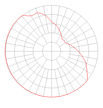 | ||||||||||||||||||
| Azimuth | Ratio | Azimuth | Ratio | Azimuth | Ratio | Azimuth | Ratio | ||||||||||||
| 0 | 0.637 | 10 | 0.573 | 20 | 0.487 | 30 | 0.415 | ||||||||||||
| 40 | 0.354 | 50 | 0.354 | 60 | 0.354 | 70 | 0.415 | ||||||||||||
| 80 | 0.487 | 90 | 0.573 | 100 | 0.673 | 110 | 0.791 | ||||||||||||
| 120 | 0.884 | 130 | 1.000 | 140 | 1.000 | 150 | 1.000 | ||||||||||||
| 160 | 1.000 | 170 | 1.000 | 180 | 1.000 | 190 | 1.000 | ||||||||||||
| 200 | 1.000 | 210 | 1.000 | 220 | 1.000 | 230 | 1.000 | ||||||||||||
| 240 | 1.000 | 250 | 1.000 | 260 | 1.000 | 270 | 1.000 | ||||||||||||
| 280 | 1.000 | 290 | 1.000 | 300 | 1.000 | 310 | 1.000 | ||||||||||||
| 320 | 1.000 | 330 | 0.884 | 340 | 0.884 | 350 | 0.791 | ||||||||||||
Structure Registration Number 1037691 Structure Type: TOWER Registered To: MURPHY, JOHN W DBA = MAC CORP Structure Address: 4440 Ne 23rd Ave Des Moines, IA County Name: Polk County ASR Issued: 05/29/1998 Site Elevation: 259.1 m (850 ft.) Structure Height: 149.4 m (490 ft.) Height Overall: 153.3 m (503 ft.) Overall Height AMSL: 412.4 m (1353 ft.) Paint & Light FAA Chapters: 1, 3, 4, 13, 21 41-36-59.0 N 93-31-36.0 W (NAD 83) 41-36-59.0 N 93-31-35.2 W (Converted to NAD 27) |
301 Maple Street, Po Box 286 Shenandoah, IA 51601 Phone: 712-246-5151 Not-for-Profit | Title: President Date: 06/30/2023 Application Certifier Family Stations, Inc. 301 Maple Street, Po Box 286 Shenandoah, IA 51601 Applicant KATHLEEN VICTORY Fletcher, Heald & Hildreth, P.l.c. 1300 North 17th Street, Suite 1100 Arlington, VA 22209 ESQ. | |||||||||||||||||