
FCCInfo.com
A Service of Cavell, Mertz & Associates, Inc.
(855) FCC-INFO
|
|
|
|
|
||||||||||||||||
|
|
Channel: 205A 88.9 MHz Litchfield, Michigan Service: FM - A full-service FM station or application. Facility ID: 766878 Fac. Service: FM Status: Construction Permit Application Accepted: 07/28/2023 Application Granted: 09/22/2023 File Number: -0000218628 CP Expires: 04/08/2025 Application Type: Minor Modification FCC Website Links: LMS Facility Details This Application Other Applications Other Applications in CDBS Including Superseded Applications Mailing Address Correspondence for Correspondence related to application -0000218628 Service Contour - Open Street Map or USGS Map (60 dBu) Service Contour - KML / Google Earth (60 dBu) Facility Type: NON-COMMERCIAL EDUC. FM Class: A, A Zone I; I-A; or II station; with 0.1kW-6kW ERP and a class contour distance <=28km Site Location: 41-53-41.6 N 84-39-53.3 W (NAD 83) Site Location: 41-53-41.4 N 84-39-53.5 W (Converted to NAD 27) Effective Radiated Power: 1 kW Antenna Center HAAT: 116 m (381 ft.) Antenna Center AMSL: 451 m (1480 ft.) Antenna Center HAG: 91 m (299 ft.) Site Elevation: 360.3 m. (1182 ft.) Height Overall*: 109.7 m (360 ft.) (* As Filed In This Application, may differ from ASR Data, Below.) Directional Antenna Antenna Make/Model: None Antenna ID: 1006063 Polarization: | ||||||||||||||||||
| Antenna Data for Antenna Id: 1006063 FM File: -0000218628 None - Service: FM | 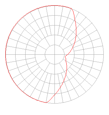 | ||||||||||||||||||
| Azimuth | Ratio | Azimuth | Ratio | Azimuth | Ratio | Azimuth | Ratio | ||||||||||||
| 0 | 1.000 | 10 | 1.000 | 20 | 1.000 | 30 | 0.829 | ||||||||||||
| 40 | 0.688 | 50 | 0.570 | 60 | 0.473 | 70 | 0.392 | ||||||||||||
| 80 | 0.325 | 90 | 0.270 | 100 | 0.224 | 110 | 0.244 | ||||||||||||
| 120 | 0.266 | 130 | 0.321 | 140 | 0.388 | 150 | 0.469 | ||||||||||||
| 160 | 0.567 | 170 | 0.685 | 180 | 0.828 | 190 | 1.000 | ||||||||||||
| 200 | 1.000 | 210 | 1.000 | 220 | 1.000 | 230 | 1.000 | ||||||||||||
| 240 | 1.000 | 250 | 1.000 | 260 | 1.000 | 270 | 1.000 | ||||||||||||
| 280 | 1.000 | 290 | 1.000 | 300 | 1.000 | 310 | 1.000 | ||||||||||||
| 320 | 1.000 | 330 | 1.000 | 340 | 1.000 | 350 | 1.000 | ||||||||||||
Structure Registration Number 1321579 Structure Type: GTOWER Registered To: Parallel Infrastructure III LLC Structure Address: 2631 Bankers Road Hillsdale, MI County Name: Hillsdale County ASR Issued: 06/06/2022 Date Built: 06/04/2022 Site Elevation: 360.3 m (1182 ft.) Structure Height: 107.6 m (353 ft.) Height Overall: 109.7 m (360 ft.) Overall Height AMSL: 470 m (1542 ft.) FAA Determination: 07/13/2021 FAA Study #: 2021-AGL-15562-OE FAA Circular #: 70/7460-1M Paint & Light FAA Chapters: 4, 8, 15 41-53-41.6 N 84-39-53.3 W (NAD 83) 41-53-41.4 N 84-39-53.5 W (Converted to NAD 27) |
172 N Cedar St Imlay City, MI 48444 Phone: 810-895-2040 Not-for-Profit | Title: President Date: 07/28/2023 Application Certifier Smile Fm 172 N Cedar St Imlay City, MI 48444 Applicant Edward Czelada Smile Fm 3302 N. Van Dyke Road Imlay City, MI 48444 | |||||||||||||||||