
FCCInfo.com
A Service of Cavell, Mertz & Associates, Inc.
(855) FCC-INFO
|
|
W270DT from 05/14/2004 |
|
|
||||||||||||||||
|
|
W270DT Channel: 270D 101.9 MHz Durham, North Carolina Service: FX - A translator or application for a translator. Facility ID: 141386 Fac. Service: FX Programming Delivery Method: Unspecified Status: Construction Permit Application Accepted: 03/26/2024 Application Granted: 04/11/2024 File Number: -0000242332 W270DT CP Expires: 04/10/2027 Application Type: Minor Modification FCC Website Links: LMS Facility Details This Application Other W270DT Applications Other W270DT Applications in CDBS Including Superseded Applications Mailing Address Correspondence for W270DT Correspondence related to application -0000242332 Service Contour - Open Street Map or USGS Map (60 dBu) Service Contour - KML / Google Earth (60 dBu) Facility Type: FM STATION Class: D, A Noncommercial educational operating with no more than 10W Site Location: 35-58-05.1 N 78-53-16.2 W (NAD 83) Site Location: 35-58-04.6 N 78-53-17.2 W (Converted to NAD 27) Effective Radiated Power: 0.25 kW Antenna Center HAAT: 0 m Antenna Center AMSL: 185.5 m (609 ft.) Antenna Center HAG: 91 m (299 ft.) Site Elevation: 94.5 m. (310 ft.) Height Overall*: 102.5 m (336 ft.) (* As Filed In This Application, may differ from ASR Data, Below.) Directional Antenna Antenna Make/Model: Jampro JCPB-2L DA Antenna ID: 134194 Polarization: H
| ||||||||||||||||||
| Antenna Data for Antenna Id: 134194 W270DT FX File: -0000242332 Jampro - JCPB-2L DA Service: FX | 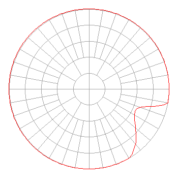 | ||||||||||||||||||
| Azimuth | Ratio | Azimuth | Ratio | Azimuth | Ratio | Azimuth | Ratio | ||||||||||||
| 0 | 1.000 | 10 | 1.000 | 20 | 1.000 | 30 | 1.000 | ||||||||||||
| 40 | 1.000 | 50 | 1.000 | 60 | 1.000 | 70 | 1.000 | ||||||||||||
| 80 | 1.000 | 90 | 1.000 | 100 | 1.000 | 110 | 0.679 | ||||||||||||
| 120 | 0.656 | 130 | 0.759 | 140 | 0.903 | 150 | 1.000 | ||||||||||||
| 160 | 1.000 | 170 | 1.000 | 180 | 1.000 | 190 | 1.000 | ||||||||||||
| 200 | 1.000 | 210 | 1.000 | 220 | 1.000 | 230 | 1.000 | ||||||||||||
| 240 | 1.000 | 250 | 1.000 | 260 | 1.000 | 270 | 1.000 | ||||||||||||
| 280 | 1.000 | 290 | 1.000 | 300 | 1.000 | 310 | 1.000 | ||||||||||||
| 320 | 1.000 | 330 | 1.000 | 340 | 1.000 | 350 | 1.000 | ||||||||||||
Structure Registration Number 1016459 Structure Type: GTOWER Registered To: Arohi Media LLC Structure Address: Nixon Street Just South Of Durham Durham, NC County Name: Durham County ASR Issued: 08/06/2015 Date Built: 06/15/2015 Site Elevation: 94.5 m (310 ft.) Structure Height: 101.5 m (333 ft.) Height Overall: 102.5 m (336 ft.) Overall Height AMSL: 197 m (646 ft.) FAA Determination: 02/28/1997 FAA Study #: 97-ASO-0729-OE FAA Circular #: 70/7460-1J Paint & Light FAA Chapters: 3, 4, 5, 13 35-58-05.1 N 78-53-16.2 W (NAD 83) 35-58-04.6 N 78-53-17.2 W (Converted to NAD 27) |
1324 Legendary Lane Morrisville, NC 27560 Phone: 248-219-8851 Limited Liability Company | Title: Managing Member Date: 03/26/2024 Application Certifier AROHI MEDIA LLC Wdur, Llc 1324 Legendary Lane Morrisville, NC 27560 Applicant John C. Trent, Esq. Putbrese, Hunsaker And Trent, Pc 200 South Church Street Woodstock, VA 22664 FCC Counsel Bruce Bellamy Munn-reese Coldwater, MI 49036 Consulting Engineer | |||||||||||||||||