
FCCInfo.com
A Service of Cavell, Mertz & Associates, Inc.
(855) FCC-INFO
|
|
WHJX from 08/31/2023 WXXJ from 11/26/2017 WXXJ from 09/24/2015 WXXJ from 05/23/2013 WXXJ from 05/16/2013 WXXJ from 09/28/2006 WXXJ from 03/01/1998 WXXJ from 10/18/1996 WXXJ from 07/22/1994 |
|  |
|
|||||||||||||||
|
|
WHJX Channel: 293A 106.5 MHz Ponte Vedra Beach, Florida Service: FM - A full-service FM station or application. Facility ID: 28894 Fac. Service: FM Analog & Digital Status: License 73.215 Station Application Accepted: 08/11/2023 Application Granted: 08/14/2023 File Number: -0000219215 License Expires: 00/00/0000 Application Type: Channel Substitution/Community of License Change Call Sign Request FCC Website Links: LMS Facility Details This Application Other WHJX Applications Other WHJX Applications in CDBS Including Superseded Applications Mailing Address Correspondence for WHJX Correspondence related to application -0000219215 Service Contour - Open Street Map or USGS Map (60 dBu) Service Contour - KML / Google Earth (60 dBu) Public Inspection Files Facility Type: FM STATION Class: A, A Zone I; I-A; or II station; with 0.1kW-6kW ERP and a class contour distance <=28km Site Location: 30-16-35.9 N 81-33-57.3 W (NAD 83) Site Location: 30-16-35.0 N 81-33-58.0 W (Converted to NAD 27) Effective Radiated Power: 6 kW Transmitter Output Power: 7.36 kW Antenna Center HAAT: 100 m (328 ft.) Antenna Center AMSL: 104 m (341 ft.) Antenna Center HAG: 96 m (315 ft.) Site Elevation: 7.9 m. (26 ft.) Height Overall*: 305 m (1001 ft.) (* As Filed In This Application, may differ from ASR Data, Below.) Directional Antenna Antenna Make/Model: Harris TAC-1M-4/4DA Antenna ID: 14912 Polarization: | ||||||||||||||||||
| Antenna Data for Antenna Id: 14912 WHJX FM File: -0000219215 Harris - TAC-1M-4/4DA Service: FM | 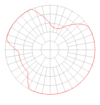 | ||||||||||||||||||
| Azimuth | Ratio | Azimuth | Ratio | Azimuth | Ratio | Azimuth | Ratio | ||||||||||||
| 0 | 0.584 | 5 | 0.525 | 10 | 0.500 | 20 | 0.500 | ||||||||||||
| 25 | 0.522 | 30 | 0.583 | 35 | 0.651 | 40 | 0.728 | ||||||||||||
| 50 | 0.890 | 60 | 1.000 | 70 | 1.000 | 80 | 1.000 | ||||||||||||
| 90 | 1.000 | 100 | 1.000 | 110 | 1.000 | 120 | 1.000 | ||||||||||||
| 130 | 1.000 | 140 | 1.000 | 150 | 1.000 | 160 | 1.000 | ||||||||||||
| 170 | 1.000 | 180 | 1.000 | 190 | 1.000 | 200 | 1.000 | ||||||||||||
| 205 | 1.000 | 210 | 0.944 | 220 | 0.769 | 225 | 0.700 | ||||||||||||
| 230 | 0.700 | 240 | 0.700 | 250 | 0.700 | 260 | 0.700 | ||||||||||||
| 265 | 0.700 | 270 | 0.763 | 280 | 0.930 | 285 | 1.000 | ||||||||||||
| 290 | 1.000 | 300 | 1.000 | 310 | 1.000 | 320 | 1.000 | ||||||||||||
| 330 | 1.000 | 335 | 1.000 | 340 | 0.900 | 345 | 0.810 | ||||||||||||
| 350 | 0.730 | 355 | 0.653 | ||||||||||||||||
Structure Registration Number 1016457 Structure Type: GTOWER Registered To: American Towers LLC Structure Address: 9050 Hogan Road (#207748) Jacksonville, FL County Name: Duval County ASR Issued: 10/26/2022 Date Built: 07/01/1988 Site Elevation: 7.9 m (26 ft.) Structure Height: 289.8 m (951 ft.) Height Overall: 305.3 m (1002 ft.) Overall Height AMSL: 313.2 m (1028 ft.) FAA Determination: 11/16/2021 FAA Study #: 2021-ASO-25036-OE FAA Circular #: 70/7460-1M Paint & Light FAA Chapters: 4, 9, 15 PRIOR STUDY 1988-ASO-1533-OE 30-16-36.8 N 81-33-57.0 W (NAD 83) 30-16-35.9 N 81-33-57.7 W (Converted to NAD 27) |
1601 W Peachtree Street Ne Atlanta, GA 30309 Phone: 404-897-7000 Limited Liability Company | Title: Vice President And Secretary Date: 08/11/2023 Application Certifier Cox Radio, Llc 1601 W Peachtree Street Ne Atlanta, GA 30309 Applicant Christina Burrow Cooley Llp 1299 Pennsylvania Avenue, Nw Suite 700 Washington, DC 20004 Legal Representative | |||||||||||||||||
| |||||||||||||||||||