
FCCInfo.com
A Service of Cavell, Mertz & Associates, Inc.
(855) FCC-INFO
|
|
KUNA-FM from 10/02/1986 |
|
|
||||||||||||||||||||||
|
|
KUNA-FM Channel: 244A 96.7 MHz La Quinta, California Service: FM - A full-service FM station or application. Facility ID: 52182 Fac. Service: FM Status: STA – Special Temporary Authority Application Accepted: 08/22/2023 Application Granted: 08/23/2023 File Number: -0000219750 STA Expires: 02/19/2024 Application Type: Engineering Special Temporary Authority FCC Website Links: LMS Facility Details This Application Other KUNA-FM Applications Other KUNA-FM Applications in CDBS Including Superseded Applications Mailing Address Correspondence for KUNA-FM Correspondence related to application -0000219750 Service Contour - Open Street Map or USGS Map (60 dBu) Service Contour - KML / Google Earth (60 dBu) Public Inspection Files Facility Type: FM STATION Class: A, A Zone I; I-A; or II station; with 0.1kW-6kW ERP and a class contour distance <=28km Site Location: 33-52-14.0 N 116-13-42.0 W (NAD 83) Site Location: 33-52-13.9 N 116-13-39.0 W (Converted to NAD 27) Effective Radiated Power: 0 kW Horiz. ; 0.2 kW Vert. Antenna Center HAAT: 0 m Horiz.; 111 m Vert. Antenna Center AMSL: 0 m Horiz.; 829.5 m Vert. Antenna Center HAG: 0 m Horiz.; 37 m Vert. Site Elevation: 792.5 m. (2600 ft.) Height Overall*: 56.4 m (185 ft.) (* As Filed In This Application, may differ from ASR Data, Below.) Directional Antenna Antenna Make/Model: Harris FML-1E Antenna ID: 1007848 Polarization: | ||||||||||||||||||||||||
| Antenna Data for Antenna Id: 1007848 KUNA-FM FM File: -0000219750 Harris - FML-1E Service: FM | 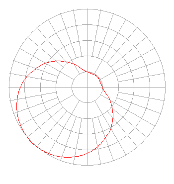 | ||||||||||||||||||||||||
| Azimuth | Ratio | Azimuth | Ratio | Azimuth | Ratio | Azimuth | Ratio | ||||||||||||||||||
| 0 | 0.195 | 10 | 0.185 | 20 | 0.180 | 30 | 0.183 | ||||||||||||||||||
| 40 | 0.185 | 50 | 0.185 | 60 | 0.183 | 70 | 0.180 | ||||||||||||||||||
| 80 | 0.185 | 90 | 0.195 | 100 | 0.215 | 110 | 0.265 | ||||||||||||||||||
| 120 | 0.340 | 130 | 0.420 | 140 | 0.515 | 150 | 0.610 | ||||||||||||||||||
| 160 | 0.690 | 170 | 0.775 | 180 | 0.850 | 190 | 0.905 | ||||||||||||||||||
| 200 | 0.950 | 210 | 0.980 | 220 | 0.995 | 225 | 1.000 | ||||||||||||||||||
| 230 | 0.995 | 240 | 0.980 | 250 | 0.950 | 260 | 0.905 | ||||||||||||||||||
| 270 | 0.850 | 280 | 0.775 | 290 | 0.690 | 300 | 0.610 | ||||||||||||||||||
| 310 | 0.515 | 320 | 0.420 | 330 | 0.340 | 340 | 0.265 | ||||||||||||||||||
| 350 | 0.215 | ||||||||||||||||||||||||
Structure Registration Number 1057857 Structure Type: TOWER Registered To: RM BROADCASTING, L.L.C. DBA = C/O KOTEEN & NAFTALIN Structure Address: 9.9 Mi Ene Of Thousand Palms Thousand Palms, CA County Name: Riverside County ASR Issued: 11/05/1998 Date Built: 10/01/1997 Site Elevation: 792.5 m (2600 ft.) Structure Height: 56.4 m (185 ft.) Height Overall: 56.4 m (185 ft.) Overall Height AMSL: 848.9 m (2785 ft.) FAA Determination: 04/02/1997 FAA Study #: 97-AWP-0718-OE Paint & Light FAA Chapters: NONE Removed expiration date from determination. Scenario 1./jjs/case#635066 33-52-14.0 N 116-13-42.0 W (NAD 83) 33-52-13.9 N 116-13-39.0 W (Converted to NAD 27) |
825 Edmonds Street St. Joseph, MO 64501 Phone: 816-271-8500 Corporation | Title: Evp And Cfo Of Parent, Npgco Date: 08/22/2023 Application Certifier GULF-CALIFORNIA BROADCAST COMPANY Gulf-california Broadcast Company 825 Edmonds Street St. Joseph, MO 64501 Applicant Elizabeth E. Spainhour Brooks, Pierce Et Al. 150 Fayetteville Street Suite 1700 Raleigh, NC 27601 Louis R. duTreil, Jr Dutreil Lundin & Rackley Inc. P.o. Box 161 Osprey, FL 34229 | |||||||||||||||||||||||
| |||||||||||||||||||||||||