
FCCInfo.com
A Service of Cavell, Mertz & Associates, Inc.
(855) FCC-INFO
|
|
W292DE from 11/14/2018 W292DE from 05/15/2008 W292DE from 08/31/2007 W292DE from 09/07/2004 |
|
|
||||||||||||||||
|
|
W292DE Channel: 292D 106.3 MHz St. Augustine, Florida Service: FX - A translator or application for a translator. Facility ID: 153096 Fac. Service: FX Programming Delivery Method: Unspecified Status: License Application Accepted: 08/23/2023 Application Granted: 08/25/2023 File Number: -0000219789 License Expires: 02/01/2028 Application Type: License To Cover FCC Website Links: LMS Facility Details This Application Other W292DE Applications Other W292DE Applications in CDBS Including Superseded Applications Mailing Address Correspondence for W292DE Correspondence related to application -0000219789 Service Contour - Open Street Map or USGS Map (60 dBu) Service Contour - KML / Google Earth (60 dBu) Facility Type: FM STATION Class: D, A Noncommercial educational operating with no more than 10W Site Location: 29-55-06.0 N 81-23-25.0 W (NAD 83) Site Location: 29-55-05.1 N 81-23-25.7 W (Converted to NAD 27) Effective Radiated Power: 0.25 kW Transmitter Output Power: 0.78 kW Antenna Center HAAT: 0 m Antenna Center AMSL: 120.5 m (395 ft.) Antenna Center HAG: 109.7 m (360 ft.) Site Elevation: 10.8 m. (35 ft.) Height Overall*: 117.3 m (385 ft.) (* As Filed In This Application, may differ from ASR Data, Below.) Directional Antenna Antenna Make/Model: Nicom BKG77 Antenna ID: 134045 Polarization: H
| ||||||||||||||||||
| Antenna Data for Antenna Id: 134045 W292DE FX File: -0000219789 Nicom - BKG77 Service: FX | 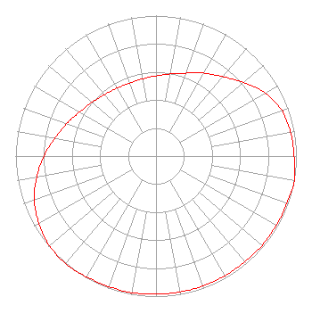 | ||||||||||||||||||
| Azimuth | Ratio | Azimuth | Ratio | Azimuth | Ratio | Azimuth | Ratio | ||||||||||||
| 0 | 0.571 | 10 | 0.594 | 20 | 0.628 | 30 | 0.682 | ||||||||||||
| 40 | 0.738 | 50 | 0.815 | 60 | 0.897 | 70 | 0.953 | ||||||||||||
| 80 | 0.973 | 90 | 0.983 | 100 | 1.000 | 110 | 0.992 | ||||||||||||
| 120 | 0.988 | 130 | 0.988 | 140 | 0.983 | 150 | 0.983 | ||||||||||||
| 160 | 0.983 | 170 | 0.983 | 180 | 0.983 | 190 | 0.988 | ||||||||||||
| 200 | 0.988 | 210 | 0.992 | 220 | 1.000 | 230 | 0.991 | ||||||||||||
| 240 | 0.963 | 250 | 0.923 | 260 | 0.862 | 270 | 0.797 | ||||||||||||
| 280 | 0.731 | 290 | 0.676 | 300 | 0.628 | 310 | 0.594 | ||||||||||||
| 320 | 0.571 | 330 | 0.558 | 340 | 0.553 | 350 | 0.558 | ||||||||||||
Structure Registration Number 1028567 Structure Type: TOWER Registered To: GLK Consultants, LLC Structure Address: 253 Zygmont Court Saint Augustine, FL County Name: St. Johns County ASR Issued: 01/02/2019 Date Built: 01/01/1982 Site Elevation: 10.8 m (35 ft.) Structure Height: 116.4 m (382 ft.) Height Overall: 117.3 m (385 ft.) Overall Height AMSL: 128.1 m (420 ft.) FAA Determination: 10/01/1992 FAA Study #: 82-ASO-2112-OE Paint & Light FAA Chapters: 1, 3, 12, 21 RED LIGHTS/PAINT 29-55-06.0 N 81-23-25.0 W (NAD 83) 29-55-05.1 N 81-23-25.7 W (Converted to NAD 27) |
2405 East Moody Boulevard Suite 402 Bunnell, FL 32110 Phone: 386-437-1992 Limited Liability Company | Title: President/ceo Date: 08/23/2023 Application Certifier FLAGLER BROADCASTING, LLC Flagler Broadcasting, Llc 2405 East Moody Boulevard Suite 402 Bunnell, FL 32110 Applicant George S. Crissey Bromo Communications, Inc. 3600 Dallas Highway Suite 230 - Pmb 164 Marietta, GA 30064 Technical Consultant Gary S Smithwick, Esq Smithwick & Belendiuk, P.c. 5028 Wisconsin Ave., N.w. Suite 301 Washington, DC 20016 | |||||||||||||||||