
FCCInfo.com
A Service of Cavell, Mertz & Associates, Inc.
(855) FCC-INFO
|
|
|
|
|
||||||||||||||||
|
|
W270BK Channel: 270D 101.9 MHz Nashville, Tennessee Service: FX - A translator or application for a translator. Facility ID: 138380 Fac. Service: FX Programming Delivery Method: Unspecified Status: Construction Permit Application Accepted: 08/28/2023 Application Granted: 09/18/2023 File Number: -0000219963 W270BK CP Expires: 09/18/2026 Application Type: Minor Modification FCC Website Links: LMS Facility Details This Application Other W270BK Applications Other W270BK Applications in CDBS Including Superseded Applications Mailing Address Correspondence for W270BK Correspondence related to application -0000219963 Service Contour - Open Street Map or USGS Map (60 dBu) Service Contour - KML / Google Earth (60 dBu) Facility Type: FM STATION Class: D, A Noncommercial educational operating with no more than 10W Site Location: 36-21-24.8 N 86-43-17.7 W (NAD 83) Site Location: 36-21-24.6 N 86-43-17.7 W (Converted to NAD 27) Effective Radiated Power: 0.25 kW Antenna Center HAAT: 0 m Antenna Center AMSL: 280.8 m Horiz.; 275.8 m Vert. (921 ft. Horiz. / 905 ft. Vert.) Antenna Center HAG: 86 m Horiz.; 81 m Vert. (282 ft. Horiz. / 266 ft. Vert.) Site Elevation: 194.8 m. (639 ft.) Height Overall*: 88.4 m (290 ft.) (* As Filed In This Application, may differ from ASR Data, Below.) Directional Antenna Antenna Make/Model: Propagation System Inc FML-1-DA Antenna ID: 127769 Polarization: H
| ||||||||||||||||||
| Antenna Data for Antenna Id: 127769 W270BK FX File: -0000219963 Propagation System Inc - FML-1-DA Service: FX | 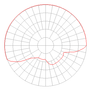 | ||||||||||||||||||
| Azimuth | Ratio | Azimuth | Ratio | Azimuth | Ratio | Azimuth | Ratio | ||||||||||||
| 0 | 1.000 | 10 | 1.000 | 20 | 1.000 | 30 | 1.000 | ||||||||||||
| 40 | 1.000 | 50 | 1.000 | 60 | 1.000 | 70 | 1.000 | ||||||||||||
| 80 | 1.000 | 90 | 1.000 | 100 | 0.800 | 110 | 0.500 | ||||||||||||
| 120 | 0.500 | 130 | 0.500 | 140 | 0.500 | 150 | 0.500 | ||||||||||||
| 160 | 0.500 | 170 | 0.450 | 180 | 0.350 | 190 | 0.350 | ||||||||||||
| 200 | 0.350 | 210 | 0.350 | 220 | 0.400 | 230 | 0.500 | ||||||||||||
| 240 | 0.800 | 250 | 1.000 | 260 | 1.000 | 270 | 1.000 | ||||||||||||
| 280 | 1.000 | 290 | 1.000 | 300 | 1.000 | 310 | 1.000 | ||||||||||||
| 320 | 1.000 | 330 | 1.000 | 340 | 1.000 | 350 | 1.000 | ||||||||||||
Structure Registration Number 1031485 Structure Type: MAST Registered To: Crown Castle GT Company LLC Structure Address: 971-973 Highway 41 West Goodlettsville, TN County Name: Sumner County ASR Issued: 05/06/2016 Date Built: 10/03/1995 Site Elevation: 194.8 m (639 ft.) Structure Height: 87.2 m (286 ft.) Height Overall: 88.4 m (290 ft.) Overall Height AMSL: 283.2 m (929 ft.) FAA Determination: 10/21/2010 FAA Study #: 2010-ASO-4624-OE FAA Circular #: 70/7460-1K Paint & Light FAA Chapters: 4, 6, 12 OM&L to remain the same as prior study = 24-HR MED-STROBES 36-21-24.8 N 86-43-17.7 W (NAD 83) 36-21-24.6 N 86-43-17.7 W (Converted to NAD 27) |
P.o. Box 150846 Nashville, TN 37215 Phone: 615-361-7560 Corporation | Title: President Date: 08/28/2023 Application Certifier WYCQ, INC. Wycq, Inc. P.o. Box 150846 Nashville, TN 37215 Applicant Charles M. Anderson Anderson Associates 5900 Lake Cyrus Drive Hoover, AL 35244 Technical Consultant Nancy A. Ory Lerman Senter Pllc 2001 L Street Nw Suite 400 Washington, DC 20036 Attorney | |||||||||||||||||