
FCCInfo.com
A Service of Cavell, Mertz & Associates, Inc.
(855) FCC-INFO
|
|
WCGE from 02/07/2022 WCGE from 01/30/2022 |
|
|
||||||||||||||||
|
|
WCGE Channel: 265B1 100.9 MHz North East Township, Pennsylvania Service: FM - A full-service FM station or application. Facility ID: 762230 Fac. Service: FM Status: License Application Accepted: 09/13/2023 Application Granted: 09/18/2023 File Number: -0000220934 License Expires: 08/01/2030 Application Type: License To Cover FCC Website Links: LMS Facility Details This Application Other WCGE Applications Other WCGE Applications in CDBS Including Superseded Applications Mailing Address Correspondence for WCGE Correspondence related to application -0000220934 Service Contour - Open Street Map or USGS Map (57 dBu) Service Contour - KML / Google Earth (57 dBu) Public Inspection Files Facility Type: NON-COMMERCIAL EDUC. FM Class: B1, A Zone I or I-A station; with 6kW-25kW ERP and a class contour distance 28km-39km Site Location: 42-11-52.2 N 79-45-11.0 W (NAD 83) Site Location: 42-11-52.0 N 79-45-11.8 W (Converted to NAD 27) Effective Radiated Power: 4.6 kW Antenna Center HAAT: 236 m (774 ft.) Antenna Center AMSL: 599 m (1965 ft.) Antenna Center HAG: 134 m (440 ft.) Site Elevation: 464.8 m. (1525 ft.) Height Overall*: 137.1 m (450 ft.) (* As Filed In This Application, may differ from ASR Data, Below.) Directional Antenna Antenna Make/Model: Shively 6810-2R-EF-DA, 2 sections Antenna ID: 0 Polarization: H | ||||||||||||||||||
| Antenna Data for Antenna Id: 0 WCGE FM File: -0000220934 Shively - 6810-2R-EF-DA, 2 sections Service: FM | 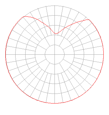 | ||||||||||||||||||
| Azimuth | Ratio | Azimuth | Ratio | Azimuth | Ratio | Azimuth | Ratio | ||||||||||||
| 0 | 0.432 | 10 | 0.447 | 20 | 0.562 | 30 | 0.708 | ||||||||||||
| 40 | 0.891 | 45 | 1.000 | 50 | 1.000 | 60 | 1.000 | ||||||||||||
| 70 | 1.000 | 80 | 1.000 | 90 | 1.000 | 100 | 1.000 | ||||||||||||
| 110 | 1.000 | 120 | 1.000 | 130 | 1.000 | 140 | 1.000 | ||||||||||||
| 150 | 1.000 | 160 | 1.000 | 170 | 1.000 | 180 | 1.000 | ||||||||||||
| 190 | 1.000 | 200 | 1.000 | 210 | 1.000 | 220 | 1.000 | ||||||||||||
| 230 | 1.000 | 240 | 1.000 | 250 | 1.000 | 260 | 1.000 | ||||||||||||
| 270 | 1.000 | 280 | 1.000 | 290 | 1.000 | 300 | 1.000 | ||||||||||||
| 310 | 1.000 | 320 | 1.000 | 330 | 0.861 | 340 | 0.684 | ||||||||||||
| 350 | 0.543 | ||||||||||||||||||
Structure Registration Number 1003200 Structure Type: GTOWER Registered To: CTI Towers Assets II, LLC Structure Address: 10612 Sheldon Corners Ne Rd Ripley, NY County Name: Chautauqua County ASR Issued: 01/24/2022 Date Built: 05/01/1995 Site Elevation: 464.8 m (1525 ft.) Structure Height: 137.1 m (450 ft.) Height Overall: 137.1 m (450 ft.) Overall Height AMSL: 601.9 m (1975 ft.) FAA Determination: 01/18/2022 FAA Study #: 2021-AEA-17195-OE FAA Circular #: 70/7460-1L Paint & Light FAA Chapters: 4, 8, 12 OM&L to remain the same as prior study = A MED-DUAL SYSTEM 42-11-52.2 N 79-45-11.0 W (NAD 83) 42-11-52.0 N 79-45-11.8 W (Converted to NAD 27) |
Bath, NY 14810 Phone: 607-776-4151 Not-for-Profit | Title: President Date: 09/13/2023 Application Certifier Family Life Ministries Family Life Ministries, Inc. Bath, NY 14810 Applicant James L Travis James Travis 12372 Huckleberry Ct Rancho Cucamonga, CA 91739 Technical Consultant Richard M Snavely, Jr. Family Life Ministries, Inc. Po Box 506 7634 Campbell Creek Road Bath, NY 14810 President | |||||||||||||||||