
FCCInfo.com
A Service of Cavell, Mertz & Associates, Inc.
(855) FCC-INFO
|
|
|
|
|
||||||||||||||||
|
|
WHSR Channel: 204B1 88.7 MHz Owosso, Michigan Service: FM - A full-service FM station or application. Facility ID: 767139 Fac. Service: FM Status: Construction Permit Application Accepted: 11/14/2023 Application Granted: 11/22/2023 File Number: -0000226239 WHSR CP Expires: 01/05/2025 Application Type: Minor Modification FCC Website Links: LMS Facility Details This Application Other WHSR Applications Other WHSR Applications in CDBS Including Superseded Applications Mailing Address Correspondence for WHSR Correspondence related to application -0000226239 Service Contour - Open Street Map or USGS Map (60 dBu) Service Contour - KML / Google Earth (60 dBu) Public Inspection Files Facility Type: NON-COMMERCIAL EDUC. FM Class: B1, A Zone I or I-A station; with 6kW-25kW ERP and a class contour distance 28km-39km Site Location: 43-04-09.4 N 84-03-45.7 W (NAD 83) Site Location: 43-04-09.3 N 84-03-45.8 W (Converted to NAD 27) Effective Radiated Power: 10 kW Antenna Center HAAT: 55 m (180 ft.) Antenna Center AMSL: 276 m (906 ft.) Antenna Center HAG: 52 m (171 ft.) Site Elevation: 224 m. (735 ft.) Height Overall*: 76.2 m (250 ft.) (* As Filed In This Application, may differ from ASR Data, Below.) Directional Antenna Antenna Make/Model: None Antenna ID: 1006063 Polarization: | ||||||||||||||||||
| Antenna Data for Antenna Id: 1006063 WHSR FM File: -0000226239 None - Service: FM | 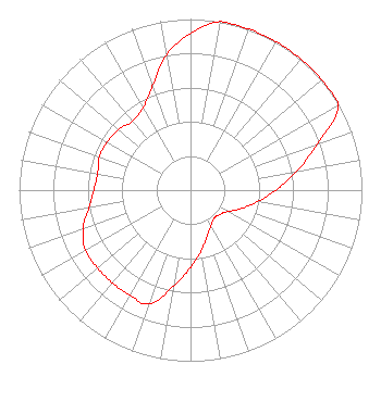 | ||||||||||||||||||
| Azimuth | Ratio | Azimuth | Ratio | Azimuth | Ratio | Azimuth | Ratio | ||||||||||||
| 0 | 0.916 | 10 | 1.000 | 20 | 1.000 | 30 | 1.000 | ||||||||||||
| 40 | 1.000 | 50 | 1.000 | 60 | 0.994 | 70 | 0.789 | ||||||||||||
| 80 | 0.627 | 90 | 0.498 | 100 | 0.396 | 110 | 0.315 | ||||||||||||
| 120 | 0.250 | 130 | 0.222 | 140 | 0.215 | 150 | 0.239 | ||||||||||||
| 160 | 0.285 | 170 | 0.359 | 180 | 0.452 | 190 | 0.569 | ||||||||||||
| 200 | 0.708 | 210 | 0.708 | 220 | 0.708 | 230 | 0.708 | ||||||||||||
| 240 | 0.708 | 250 | 0.667 | 260 | 0.602 | 270 | 0.564 | ||||||||||||
| 280 | 0.550 | 290 | 0.566 | 300 | 0.562 | 310 | 0.551 | ||||||||||||
| 320 | 0.526 | 330 | 0.554 | 340 | 0.650 | 350 | 0.804 | ||||||||||||
Structure Registration Number 1298334 Structure Type: LTOWER Registered To: Skyway Towers, LLC Structure Address: Riley Road (mi-8587 Juddville & Kerby) Corunna, MI County Name: Shiawassee County ASR Issued: 02/11/2016 Date Built: 06/21/2016 Site Elevation: 224 m (735 ft.) Structure Height: 73.2 m (240 ft.) Height Overall: 76.2 m (250 ft.) Overall Height AMSL: 300.2 m (985 ft.) FAA Determination: 09/15/2015 FAA Study #: 2015-AGL-11816-OE FAA Circular #: 70/7460-1K Paint & Light FAA Chapters: 4, 8, 12 Removed expiration date from determination. Scenario 1./jjs/case#635066 43-04-09.4 N 84-03-45.7 W (NAD 83) 43-04-09.3 N 84-03-45.8 W (Converted to NAD 27) |
Cadillac, MI 49601 Phone: 231-468-2087 Not-for-Profit | Title: President Date: 11/14/2023 Application Certifier West Central Michigan Media Ministries Cadillac, MI 49601 Applicant Bruce Bellamy Munn-reese Po Box 220 Coldwater, MI 49036 Consulting Engineer DONALD MARTIN Law Office Of Donald E Martin Falls Church, VA 22041 Attorney | |||||||||||||||||