
FCCInfo.com
A Service of Cavell, Mertz & Associates, Inc.
(855) FCC-INFO
|
|
|
|  |
|
|||||||||||||||
|
|
KIHS Channel: 203C3 88.5 MHz Adel, Iowa Service: FM - A full-service FM station or application. Facility ID: 92489 Fac. Service: FM Status: License Application Accepted: 11/09/2023 Application Granted: 11/17/2023 File Number: -0000225665 License Expires: 02/01/2029 Application Type: License To Cover FCC Website Links: LMS Facility Details This Application Other KIHS Applications Other KIHS Applications in CDBS Including Superseded Applications Mailing Address Correspondence for KIHS Correspondence related to application -0000225665 Service Contour - Open Street Map or USGS Map (60 dBu) Service Contour - KML / Google Earth (60 dBu) Public Inspection Files Facility Type: NON-COMMERCIAL EDUC. FM Class: C3, A Zone II station; with 6kW-25kW ERP and a class contour distance 28km-39km Site Location: 41-36-09.1 N 94-02-55.4 W (NAD 83) Site Location: 41-36-09.1 N 94-02-54.6 W (Converted to NAD 27) Effective Radiated Power: 12.5 kW Transmitter Output Power: 0.649 kW Antenna Center HAAT: 57 m (187 ft.) Antenna Center AMSL: 360 m (1181 ft.) Antenna Center HAG: 46 m (151 ft.) Site Elevation: 314.2 m. (1031 ft.) Height Overall*: 94.5 m (310 ft.) (* As Filed In This Application, may differ from ASR Data, Below.) Directional Antenna Antenna Make/Model: Electronics Research Inc. LP-4E-DA-HW, 4 sections Antenna ID: 0 Polarization: H | ||||||||||||||||||
| Antenna Data for Antenna Id: 0 KIHS FM File: -0000225665 Electronics Research Inc. - LP-4E-DA-HW, 4 sections Service: FM | 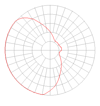 | ||||||||||||||||||
| Azimuth | Ratio | Azimuth | Ratio | Azimuth | Ratio | Azimuth | Ratio | ||||||||||||
| 0 | 0.410 | 10 | 0.326 | 20 | 0.260 | 30 | 0.230 | ||||||||||||
| 40 | 0.230 | 50 | 0.230 | 60 | 0.230 | 70 | 0.240 | ||||||||||||
| 80 | 0.260 | 90 | 0.255 | 100 | 0.220 | 110 | 0.220 | ||||||||||||
| 120 | 0.250 | 130 | 0.312 | 140 | 0.392 | 150 | 0.490 | ||||||||||||
| 160 | 0.615 | 170 | 0.772 | 180 | 0.900 | 190 | 1.000 | ||||||||||||
| 200 | 1.000 | 210 | 1.000 | 220 | 1.000 | 230 | 1.000 | ||||||||||||
| 240 | 1.000 | 250 | 1.000 | 260 | 1.000 | 270 | 1.000 | ||||||||||||
| 280 | 1.000 | 290 | 1.000 | 300 | 1.000 | 310 | 1.000 | ||||||||||||
| 320 | 0.930 | 330 | 0.800 | 340 | 0.640 | 350 | 0.510 | ||||||||||||
Structure Registration Number 1018053 Structure Type: TOWER Registered To: SBA Structures, LLC Structure Address: 3 Mi Sw Adel, IA County Name: Dallas County ASR Issued: 04/26/2013 Date Built: 09/06/1989 Site Elevation: 314.2 m (1031 ft.) Structure Height: 91 m (299 ft.) Height Overall: 94.5 m (310 ft.) Overall Height AMSL: 408.7 m (1341 ft.) FAA Determination: 03/14/2001 FAA Study #: 01-ACE-0394-OE FAA Circular #: 70/7460-1K Paint & Light FAA Chapters: 4, 8, 12 41-36-09.1 N 94-02-55.4 W (NAD 83) 41-36-09.1 N 94-02-54.6 W (Converted to NAD 27) |
1355 50th Street Suite 500 West Des Moines, IA 50266 Phone: 515-223-1150 Corporation | Title: President Date: 11/09/2023 Application Certifier ST. GABRIEL COMMUNICATIONS St. Gabriel Communications 1355 50th Street Suite 500 West Des Moines, IA 50266 Applicant JOHN WELLS KING, ESQ Law Office Of John Wells King, Pllc 4051 Shoal Creek Lane E Jacksonville, FL 32225 Counsel Bruce Bellamy Munn-reese Coldwater, MI 49036 Consulting Engineer | |||||||||||||||||