
FCCInfo.com
A Service of Cavell, Mertz & Associates, Inc.
(855) FCC-INFO
|
|
WFMA from 03/14/2018 WFMA from 11/28/1989 WFMA from 09/18/1989 |
|  |
|
|||||||||||||||
|
|
WFMA Channel: 275C2 102.9 MHz Marion, Alabama Service: FM - A full-service FM station or application. Facility ID: 37721 Fac. Service: FM Status: License 73.215 Station Application Accepted: 01/09/2024 Application Granted: 01/26/2024 File Number: -0000235064 License Expires: 04/01/2028 Application Type: License To Cover FCC Website Links: LMS Facility Details This Application Other WFMA Applications Other WFMA Applications in CDBS Including Superseded Applications Mailing Address Correspondence for WFMA Correspondence related to application -0000235064 Service Contour - Open Street Map or USGS Map (60 dBu) Service Contour - KML / Google Earth (60 dBu) Public Inspection Files Facility Type: NON-COMMERCIAL EDUC. FM Class: C2, A Zone II station; with 25kW-50kW ERP and a class contour distance 39km-52km Site Location: 32-49-47.3 N 87-25-47.0 W (NAD 83) Site Location: 32-49-46.8 N 87-25-47.0 W (Converted to NAD 27) Effective Radiated Power: 24 kW Transmitter Output Power: 4 kW Antenna Center HAAT: 192 m (630 ft.) Antenna Center AMSL: 296 m (971 ft.) Antenna Center HAG: 171 m (561 ft.) Site Elevation: 125 m. (410 ft.) Height Overall*: 182.9 m (600 ft.) (* As Filed In This Application, may differ from ASR Data, Below.) Directional Antenna Antenna Make/Model: Electronics Research Inc. LP-8E-DA, 8 sections Antenna ID: 90628 Polarization: H | ||||||||||||||||||
| Antenna Data for Antenna Id: 90628 WFMA FM File: -0000235064 Electronics Research Inc. - LP-8E-DA, 8 sections Service: FM | 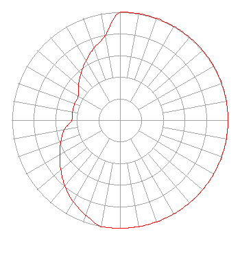 | ||||||||||||||||||
| Azimuth | Ratio | Azimuth | Ratio | Azimuth | Ratio | Azimuth | Ratio | ||||||||||||
| 0 | 1.000 | 10 | 1.000 | 20 | 1.000 | 30 | 1.000 | ||||||||||||
| 40 | 1.000 | 50 | 1.000 | 60 | 1.000 | 70 | 1.000 | ||||||||||||
| 80 | 1.000 | 90 | 1.000 | 100 | 1.000 | 110 | 1.000 | ||||||||||||
| 120 | 1.000 | 130 | 1.000 | 140 | 1.000 | 150 | 1.000 | ||||||||||||
| 160 | 1.000 | 170 | 1.000 | 180 | 1.000 | 190 | 1.000 | ||||||||||||
| 200 | 0.933 | 210 | 0.870 | 220 | 0.794 | 230 | 0.716 | ||||||||||||
| 240 | 0.645 | 250 | 0.582 | 260 | 0.524 | 270 | 0.446 | ||||||||||||
| 280 | 0.446 | 290 | 0.446 | 300 | 0.446 | 310 | 0.501 | ||||||||||||
| 320 | 0.562 | 330 | 0.630 | 340 | 0.707 | 350 | 0.794 | ||||||||||||
Structure Registration Number 1266121 Structure Type: GTOWER Registered To: Educational Media Foundation Structure Address: Northeast Intersection Of Hw 29 And C.r. 154, North Perry County, Al Marion, AL County Name: Perry County ASR Issued: 01/24/2024 Date Built: 11/24/2009 Site Elevation: 125 m (410 ft.) Structure Height: 181.9 m (597 ft.) Height Overall: 182.9 m (600 ft.) Overall Height AMSL: 307.9 m (1010 ft.) FAA Determination: 09/11/2019 FAA Study #: 2019-ASO-1508-OE FAA Circular #: 70/7460-1L Paint & Light FAA Chapters: 3, 4, 5, 12 PRIOR STUDY 2008-ASO-4105-OE 32-49-47.3 N 87-25-47.0 W (NAD 83) 32-49-46.8 N 87-25-47.0 W (Converted to NAD 27) |
5700 West Oaks Boulevard Rocklin, CA 95765 Phone: 916-251-1600 Not-for-Profit | Title: Chief Financial Officer Date: 01/09/2024 Application Certifier EDUCATIONAL MEDIA FOUNDATION Educational Media Foundation 5700 West Oaks Boulevard Rocklin, CA 95765 Applicant MARY O'CONNOR Wilkinson Barker Knauer, Llp 1800 M Street, N.w. Suite 800n Washington, DC 20036 JAMES L TRAVIS Educational Media Foundation 5700 West Oaks Blvd Rocklin, CA 95765 FCC Compliance Engineer | |||||||||||||||||