
FCCInfo.com
A Service of Cavell, Mertz & Associates, Inc.
(855) FCC-INFO
|
|
|
|  |
|
||||||||||||||||||
|
|
KACS Channel: 213C2 90.5 MHz Chehalis, Washington Service: FM - A full-service FM station or application. Facility ID: 10685 Fac. Service: FM Status: Construction Permit Application Accepted: 01/18/2024 Application Granted: 02/05/2024 File Number: -0000235741 KACS CP Expires: 05/27/2025 Application Type: Minor Modification FCC Website Links: LMS Facility Details This Application Other KACS Applications Other KACS Applications in CDBS Including Superseded Applications Mailing Address Correspondence for KACS Correspondence related to application -0000235741 Service Contour - Open Street Map or USGS Map (60 dBu) Service Contour - KML / Google Earth (60 dBu) Public Inspection Files Facility Type: NON-COMMERCIAL EDUC. FM Class: C2, A Zone II station; with 25kW-50kW ERP and a class contour distance 39km-52km Site Location: 46-58-22.4 N 123-08-22.1 W (NAD 83) Site Location: 46-58-23.1 N 123-08-17.6 W (Converted to NAD 27) Effective Radiated Power: 0.5 kW Antenna Center HAAT: 697 m (2287 ft.) Antenna Center AMSL: 897 m (2943 ft.) Antenna Center HAG: 91 m (299 ft.) Site Elevation: 805.9 m. (2644 ft.) Height Overall*: 122.8 m (403 ft.) (* As Filed In This Application, may differ from ASR Data, Below.) Directional Antenna Antenna Make/Model: None Antenna ID: 1006063 Polarization:
| |||||||||||||||||||||
| Antenna Data for Antenna Id: 1006063 KACS FM File: -0000235741 None - Service: FM | 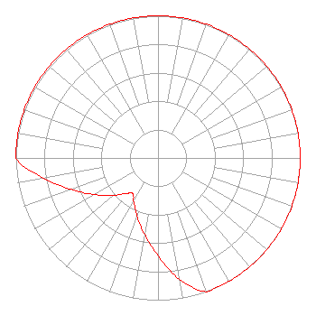 | |||||||||||||||||||||
| Azimuth | Ratio | Azimuth | Ratio | Azimuth | Ratio | Azimuth | Ratio | |||||||||||||||
| 0 | 1.000 | 10 | 1.000 | 20 | 1.000 | 30 | 1.000 | |||||||||||||||
| 40 | 1.000 | 50 | 1.000 | 60 | 1.000 | 70 | 1.000 | |||||||||||||||
| 80 | 1.000 | 90 | 1.000 | 100 | 1.000 | 110 | 1.000 | |||||||||||||||
| 120 | 1.000 | 130 | 1.000 | 140 | 1.000 | 150 | 1.000 | |||||||||||||||
| 160 | 1.000 | 170 | 0.866 | 180 | 0.688 | 190 | 0.546 | |||||||||||||||
| 200 | 0.434 | 210 | 0.345 | 215 | 0.307 | 220 | 0.325 | |||||||||||||||
| 230 | 0.410 | 240 | 0.516 | 250 | 0.649 | 260 | 0.818 | |||||||||||||||
| 270 | 1.000 | 280 | 1.000 | 290 | 1.000 | 300 | 1.000 | |||||||||||||||
| 310 | 1.000 | 320 | 1.000 | 330 | 1.000 | 340 | 1.000 | |||||||||||||||
| 350 | 1.000 | |||||||||||||||||||||
Structure Registration Number 1282343 Structure Type: GTOWER Registered To: 3 Cities, Inc. Structure Address: Capitol Peak Littlerock, WA County Name: Thurston County ASR Issued: 01/10/2024 Date Built: 01/24/2014 Site Elevation: 805.9 m (2644 ft.) Structure Height: 121.9 m (400 ft.) Height Overall: 122.8 m (403 ft.) Overall Height AMSL: 928.7 m (3047 ft.) FAA Determination: 10/22/2023 FAA Study #: 2023-ANM-6144-OE FAA Circular #: 70/7460-1K Paint & Light FAA Chapters: 3, 4, 5, 12 OM&L to remain the same as prior study = PAINT/RED LIGHTS 46-58-22.4 N 123-08-22.1 W (NAD 83) 46-58-23.1 N 123-08-17.6 W (Converted to NAD 27) |
Unit A 2451 N.e. Kresky Chehalis, WA 98532 Phone: 360-740-9436 Not-for-Profit | Title: Secretary Date: 01/18/2024 Application Certifier CHEHALIS VALLEY EDUCATIONAL FOUNDATION Chehalis Valley Educational Foundation Unit A 2451 N.e. Kresky Chehalis, WA 98532 Applicant DONALD MARTIN Donald E. Martin, P.c. P.o. Box 8433 Falls Church, VA 22041 ERIK C SWANSON, PE Hatfield & Dawson Hatfield & Dawson Consulting Engineers 9500 Greenwood Ave N Seattle, WA 98103 CONSULTING ENGINEER | ||||||||||||||||||||
| ||||||||||||||||||||||