
FCCInfo.com
A Service of Cavell, Mertz & Associates, Inc.
(855) FCC-INFO
|
|
K295CB from 11/26/2013 |
|
|
||||||||||||||||
|
|
K231DI Channel: 231D 94.1 MHz Des Moines, Iowa Service: FX - A translator or application for a translator. Facility ID: 144879 Fac. Service: FX Programming Delivery Method: Unspecified Status: License Application Accepted: 01/24/2024 Application Granted: 02/05/2024 File Number: -0000236281 License Expires: 02/01/2029 Application Type: License To Cover FCC Website Links: LMS Facility Details This Application Other K231DI Applications Other K231DI Applications in CDBS Including Superseded Applications Mailing Address Correspondence for K231DI Correspondence related to application -0000236281 Service Contour - Open Street Map or USGS Map (60 dBu) Service Contour - KML / Google Earth (60 dBu) Facility Type: FM STATION Class: D, A Noncommercial educational operating with no more than 10W Site Location: 41-38-05.0 N 93-34-44.8 W (NAD 83) Site Location: 41-38-05.0 N 93-34-44.0 W (Converted to NAD 27) Effective Radiated Power: 0.119 kW Transmitter Output Power: 0.293 kW Antenna Center HAAT: 0 m Antenna Center AMSL: 395 m (1296 ft.) Antenna Center HAG: 112.2 m (368 ft.) Site Elevation: 282.8 m. (928 ft.) Height Overall*: 157.8 m (518 ft.) (* As Filed In This Application, may differ from ASR Data, Below.) Directional Antenna Antenna Make/Model: Nicom BKG77 Antenna ID: 127386 Polarization: H
| ||||||||||||||||||
| Antenna Data for Antenna Id: 127386 K231DI FX File: -0000236281 Nicom - BKG77 Service: FX | 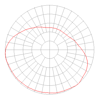 | ||||||||||||||||||
| Azimuth | Ratio | Azimuth | Ratio | Azimuth | Ratio | Azimuth | Ratio | ||||||||||||
| 0 | 0.493 | 10 | 0.493 | 20 | 0.493 | 30 | 0.493 | ||||||||||||
| 40 | 0.493 | 50 | 0.507 | 60 | 0.536 | 70 | 0.596 | ||||||||||||
| 80 | 0.643 | 90 | 0.728 | 100 | 0.826 | 110 | 0.908 | ||||||||||||
| 120 | 0.947 | 130 | 0.966 | 140 | 1.000 | 150 | 0.984 | ||||||||||||
| 160 | 0.976 | 170 | 0.976 | 180 | 0.966 | 190 | 0.966 | ||||||||||||
| 200 | 0.966 | 210 | 0.966 | 220 | 0.966 | 230 | 0.976 | ||||||||||||
| 240 | 0.976 | 250 | 0.984 | 260 | 1.000 | 270 | 0.982 | ||||||||||||
| 280 | 0.927 | 290 | 0.852 | 300 | 0.762 | 310 | 0.692 | ||||||||||||
| 320 | 0.627 | 330 | 0.581 | 340 | 0.536 | 350 | 0.504 | ||||||||||||
Structure Registration Number 1016626 Structure Type: TOWER Registered To: ELECTRONIC ENGINEERING CO Structure Address: 4039 Delaware Des Moines, IA County Name: Polk County ASR Issued: 05/07/2004 Date Built: 11/23/2004 Site Elevation: 282.8 m (928 ft.) Structure Height: 151.1 m (496 ft.) Height Overall: 157.8 m (518 ft.) Overall Height AMSL: 440.6 m (1446 ft.) FAA Determination: 12/01/2003 FAA Study #: 2003-ACE-2644-OE Paint & Light FAA Chapters: A2, H, 1 Removed expiration date from determination. Scenario 1./jjs/case#635066 41-38-05.0 N 93-34-44.9 W (NAD 83) 41-38-05.0 N 93-34-44.1 W (Converted to NAD 27) |
2111 Grand Avenue Des Moines, IA 50312 Phone: 515-725-1705 Not-for-Profit | Title: Sole Member Date: 01/24/2024 Application Certifier YOUNGERS COLORADO BROADCASTING LLC Youngers Colorado Broadcasting Llc 3004 70th Avenue Greeley, CO 80634 Applicant A. Wray Fitch, III Gammon & Grange, P.c. 8280 Greensboro Drive, 7th Floor Mclean, VA 22102 Kevin J. Youngers Youngers Colorado Broadcasting Llc 3004 70th Ave Greeley, CO 80634 TECHNICAL CONSULTANT | |||||||||||||||||