
FCCInfo.com
A Service of Cavell, Mertz & Associates, Inc.
(855) FCC-INFO
|
|
|
|
|
||||||||||||||||
|
|
Channel: 207B1 89.3 MHz Tower Hill, Illinois Service: FM - A full-service FM station or application. Facility ID: 766074 Fac. Service: FM Status: Construction Permit Application Accepted: 03/05/2024 Application Granted: 03/29/2024 File Number: -0000240374 CP Expires: 12/20/2024 Application Type: Minor Modification FCC Website Links: LMS Facility Details This Application Other Applications Other Applications in CDBS Including Superseded Applications Mailing Address Correspondence for Correspondence related to application -0000240374 Service Contour - Open Street Map or USGS Map (60 dBu) Service Contour - KML / Google Earth (60 dBu) Facility Type: NON-COMMERCIAL EDUC. FM Class: B1, A Zone I or I-A station; with 6kW-25kW ERP and a class contour distance 28km-39km Site Location: 39-18-23.8 N 88-55-57.6 W (NAD 83) Site Location: 39-18-23.7 N 88-55-57.3 W (Converted to NAD 27) Effective Radiated Power: 4.65 kW Antenna Center HAAT: 155 m (509 ft.) Antenna Center AMSL: 340 m (1115 ft.) Antenna Center HAG: 98 m (322 ft.) Site Elevation: 242.3 m. (795 ft.) Height Overall*: 156.1 m (512 ft.) (* As Filed In This Application, may differ from ASR Data, Below.) Directional Antenna Antenna Make/Model: None Antenna ID: 1006063 Polarization: | ||||||||||||||||||
| Antenna Data for Antenna Id: 1006063 FM File: -0000240374 None - Service: FM | 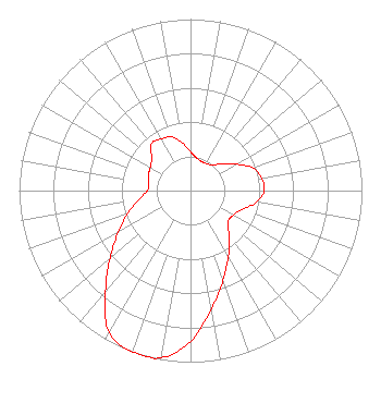 | ||||||||||||||||||
| Azimuth | Ratio | Azimuth | Ratio | Azimuth | Ratio | Azimuth | Ratio | ||||||||||||
| 0 | 0.226 | 10 | 0.195 | 20 | 0.181 | 30 | 0.183 | ||||||||||||
| 40 | 0.196 | 50 | 0.244 | 60 | 0.308 | 70 | 0.387 | ||||||||||||
| 80 | 0.421 | 90 | 0.430 | 100 | 0.392 | 110 | 0.318 | ||||||||||||
| 120 | 0.287 | 130 | 0.284 | 140 | 0.351 | 150 | 0.442 | ||||||||||||
| 160 | 0.555 | 170 | 0.699 | 180 | 0.880 | 190 | 0.990 | ||||||||||||
| 200 | 1.000 | 210 | 0.952 | 220 | 0.771 | 230 | 0.613 | ||||||||||||
| 240 | 0.487 | 250 | 0.387 | 260 | 0.307 | 270 | 0.251 | ||||||||||||
| 280 | 0.246 | 290 | 0.262 | 300 | 0.271 | 310 | 0.295 | ||||||||||||
| 320 | 0.356 | 330 | 0.347 | 340 | 0.333 | 350 | 0.282 | ||||||||||||
Structure Registration Number 1008862 Structure Type: TOWER Registered To: CRAIG, LARRY:CRAIG, CANDICE DBA = CRAIG ANTENNA SERVICE Structure Address: 8.1 Mi Sw Of Rts 128 & 16 Lakewood, IL County Name: Shelby County ASR Issued: 12/18/2000 Date Built: 10/27/1992 Site Elevation: 242.3 m (795 ft.) Structure Height: 151.5 m (497 ft.) Height Overall: 156.1 m (512 ft.) Overall Height AMSL: 398.4 m (1307 ft.) FAA Determination: 08/23/2000 FAA Study #: 00-AGL-4656-OE FAA Circular #: 70/7460-1H Paint & Light FAA Chapters: 3, 4, 6, 13 PRIOR FAA 93-AGL-1706-OE 39-18-23.8 N 88-55-57.6 W (NAD 83) 39-18-23.7 N 88-55-57.3 W (Converted to NAD 27) |
Cadillac, MI 49601 Phone: 231-468-2087 Not-for-Profit | Title: President Date: 03/05/2024 Application Certifier West Central Michigan Media Ministries Cadillac, MI 49601 Applicant DONALD MARTIN Law Office Of Donald E Martin Falls Church, VA 22041 Attorney Bruce Bellamy Munn-reese Po Box 220 Coldwater, MI 49036 Consulting Engineer | |||||||||||||||||