
FCCInfo.com
A Service of Cavell, Mertz & Associates, Inc.
(855) FCC-INFO
|
|
|
|
|
||||||||||||||||
|
|
K267AO Channel: 267D 101.3 MHz Fredericksburg, Texas Service: FX - A translator or application for a translator. Facility ID: 139319 Fac. Service: FX Programming Delivery Method: Unspecified Status: License Application Accepted: 02/08/2024 Application Granted: 02/14/2024 File Number: -0000238588 License Expires: 08/01/2029 Application Type: License To Cover FCC Website Links: LMS Facility Details This Application Other K267AO Applications Other K267AO Applications in CDBS Including Superseded Applications Mailing Address Correspondence for K267AO Correspondence related to application -0000238588 Service Contour - Open Street Map or USGS Map (60 dBu) Service Contour - KML / Google Earth (60 dBu) Facility Type: NON-COMMERCIAL EDUC. FM Class: D, A Noncommercial educational operating with no more than 10W Site Location: 30-17-29.8 N 98-49-59.5 W (NAD 83) Site Location: 30-17-29.1 N 98-49-58.4 W (Converted to NAD 27) Effective Radiated Power: 0.25 kW Transmitter Output Power: 0.2 kW Antenna Center HAAT: 0 m Horiz.; -18.2 m Vert. Antenna Center AMSL: 667.7 m (2191 ft.) Antenna Center HAG: 73 m (240 ft.) Site Elevation: 594.7 m. (1951 ft.) Height Overall*: 81 m (266 ft.) (* As Filed In This Application, may differ from ASR Data, Below.) Directional Antenna Antenna Make/Model: Scala 2xYA7-FMH/URM/SV Antenna ID: 78498 Polarization: H
| ||||||||||||||||||
| Antenna Data for Antenna Id: 78498 K267AO FX File: -0000238588 Scala - 2xYA7-FMH/URM/SV Service: FX | 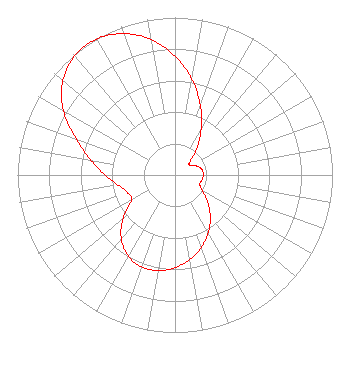 | ||||||||||||||||||
| Azimuth | Ratio | Azimuth | Ratio | Azimuth | Ratio | Azimuth | Ratio | ||||||||||||
| 0 | 0.755 | 10 | 0.617 | 20 | 0.471 | 30 | 0.332 | ||||||||||||
| 40 | 0.212 | 50 | 0.118 | 60 | 0.120 | 70 | 0.157 | ||||||||||||
| 80 | 0.176 | 90 | 0.180 | 100 | 0.175 | 110 | 0.167 | ||||||||||||
| 120 | 0.200 | 130 | 0.271 | 140 | 0.348 | 150 | 0.422 | ||||||||||||
| 160 | 0.489 | 170 | 0.545 | 180 | 0.588 | 190 | 0.616 | ||||||||||||
| 200 | 0.621 | 210 | 0.595 | 220 | 0.531 | 230 | 0.430 | ||||||||||||
| 240 | 0.318 | 250 | 0.322 | 260 | 0.367 | 270 | 0.443 | ||||||||||||
| 280 | 0.544 | 290 | 0.666 | 300 | 0.819 | 310 | 0.930 | ||||||||||||
| 320 | 0.990 | 330 | 0.997 | 340 | 0.955 | 350 | 0.872 | ||||||||||||
Structure Registration Number 1268617 Structure Type: TOWER Registered To: Cellco Partnership Structure Address: 2731 N State Hwy 16 Fredericksburg, TX County Name: Gillespie County ASR Issued: 02/04/2019 Date Built: 11/05/2009 Site Elevation: 594.7 m (1951 ft.) Structure Height: 79.2 m (260 ft.) Height Overall: 81 m (266 ft.) Overall Height AMSL: 675.7 m (2217 ft.) FAA Determination: 11/23/2009 FAA Study #: 2009-ASW-5614-OE FAA Circular #: 70/7460-1K Paint & Light FAA Chapters: 4, 8, 12 OM&L to remain the same as prior study = A MED-DUAL SYSTEM 30-17-29.8 N 98-49-59.5 W (NAD 83) 30-17-29.1 N 98-49-58.4 W (Converted to NAD 27) |
4020 Manchaca Road Austin, TX 78704 Phone: 512-829-4680 Not-for-Profit | Title: President Date: 02/08/2024 Application Certifier SUN RADIO FOUNDATION Sun Radio Foundation Austin, TX 78709 Applicant Justin Asher Asher Broadcast Consulting, Llc 579 Babcock Road Bronson, MI 49028-9347 Technical Consultant John C. Trent, Esq Putbrese Hunsaker & Trent, P.c. 200 South Church Street Woodstock, VA 22664 Counsel | |||||||||||||||||