
FCCInfo.com
A Service of Cavell, Mertz & Associates, Inc.
(855) FCC-INFO
|
|
|
|
|
||||||||||||||||
|
|
W281CE Channel: 281D 104.1 MHz Tuscaloosa, Alabama Service: FX - A translator or application for a translator. Facility ID: 201517 Fac. Service: FX Programming Delivery Method: Unspecified Status: License 73.215 Station Application Accepted: 02/26/2024 Application Pending: 02/26/2024 File Number: -0000239785 License Expires: 09/19/2026 Application Type: License To Cover FCC Website Links: LMS Facility Details This Application Other W281CE Applications Other W281CE Applications in CDBS Including Superseded Applications Mailing Address Correspondence for W281CE Correspondence related to application -0000239785 Service Contour - Open Street Map or USGS Map (60 dBu) Service Contour - KML / Google Earth (60 dBu) Facility Type: FM STATION Class: D, A Noncommercial educational operating with no more than 10W Site Location: 33-12-51.0 N 87-29-23.9 W (NAD 83) Site Location: 33-12-50.6 N 87-29-23.9 W (Converted to NAD 27) Effective Radiated Power: 0.08 kW Antenna Center HAAT: 0 m Antenna Center AMSL: 251.5 m (825 ft.) Antenna Center HAG: 136 m (446 ft.) Site Elevation: 115.5 m. (379 ft.) Height Overall*: 152.1 m (499 ft.) (* As Filed In This Application, may differ from ASR Data, Below.) Directional Antenna Antenna Make/Model: Bext TFC2K Antenna ID: 1005617 Polarization: H
| ||||||||||||||||||
| Antenna Data for Antenna Id: 1005617 W281CE FX File: -0000239785 Bext - TFC2K Service: FX | 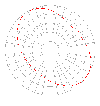 | ||||||||||||||||||
| Azimuth | Ratio | Azimuth | Ratio | Azimuth | Ratio | Azimuth | Ratio | ||||||||||||
| 0 | 0.889 | 10 | 0.832 | 20 | 0.779 | 30 | 0.738 | ||||||||||||
| 40 | 0.714 | 50 | 0.709 | 60 | 0.772 | 70 | 0.754 | ||||||||||||
| 80 | 0.801 | 90 | 0.856 | 100 | 0.913 | 110 | 0.963 | ||||||||||||
| 120 | 0.994 | 130 | 0.998 | 131 | 1.000 | 140 | 0.972 | ||||||||||||
| 150 | 0.912 | 160 | 0.831 | 170 | 0.754 | 180 | 0.689 | ||||||||||||
| 190 | 0.626 | 200 | 0.582 | 210 | 0.559 | 220 | 0.552 | ||||||||||||
| 230 | 0.554 | 240 | 0.564 | 250 | 0.582 | 260 | 0.611 | ||||||||||||
| 270 | 0.656 | 280 | 0.715 | 290 | 0.768 | 300 | 0.838 | ||||||||||||
| 310 | 0.911 | 320 | 0.963 | 330 | 0.983 | 340 | 0.974 | ||||||||||||
| 350 | 0.940 | ||||||||||||||||||
Structure Registration Number 1309246 Structure Type: GTOWER Registered To: TTI, Inc. Structure Address: Along Hammer Road (450 Crescent Ln E) Tuscaloosa, AL County Name: Tuscaloosa County ASR Issued: 02/19/2019 Date Built: 09/17/2019 Site Elevation: 115.5 m (379 ft.) Structure Height: 150.6 m (494 ft.) Height Overall: 152.1 m (499 ft.) Overall Height AMSL: 267.6 m (878 ft.) FAA Determination: 12/15/2017 FAA Study #: 2017-ASO-21351-OE FAA Circular #: 70/7460-1L Paint & Light FAA Chapters: 4, 8, 12 Removed expiration date from determination. Scenario 1./jjs/case#635066 33-12-51.0 N 87-29-23.9 W (NAD 83) 33-12-50.6 N 87-29-23.9 W (Converted to NAD 27) |
P.o. Box 70427 Tuscaloosa, AL 35401 Phone: 205-345-4787 Corporation | Title: President Date: 02/26/2024 Application Certifier LAWSON OF TUSCALOOSA, INC. Lawson Of Tuscaloosa, Inc. P.o. Box 70427 Tuscaloosa, AL 35401 Applicant Dan J Alpert The Law Office Of Dan J. Alpert 2120 21st Rd. N Arlington, VA 22201 Legal Counsel David Baughn Dave Baughn Consulting 5 The Highlands Tuscaloosa, AL 35407 | |||||||||||||||||