
FCCInfo.com
A Service of Cavell, Mertz & Associates, Inc.
(855) FCC-INFO
|
|
WYFW from 12/09/1986 |
|  |
|
|||||||||||||||
|
|
WYFW Channel: 208A 89.5 MHz Winder, Georgia Service: FM - A full-service FM station or application. Facility ID: 5125 Fac. Service: FM Status: Construction Permit Application Accepted: 03/26/2024 Application Granted: 04/09/2024 File Number: -0000242329 WYFW CP Expires: 04/09/2027 Application Type: Minor Modification FCC Website Links: LMS Facility Details This Application Other WYFW Applications Other WYFW Applications in CDBS Including Superseded Applications Mailing Address Correspondence for WYFW Correspondence related to application -0000242329 Service Contour - Open Street Map or USGS Map (60 dBu) Service Contour - KML / Google Earth (60 dBu) Public Inspection Files Facility Type: NON-COMMERCIAL EDUC. FM Class: A, A Zone I; I-A; or II station; with 0.1kW-6kW ERP and a class contour distance <=28km Site Location: 33-59-46.8 N 83-45-18.2 W (NAD 83) Site Location: 33-59-46.4 N 83-45-18.6 W (Converted to NAD 27) Effective Radiated Power: 5 kW Antenna Center HAAT: 77 m (253 ft.) Antenna Center AMSL: 347 m (1138 ft.) Antenna Center HAG: 44 m (144 ft.) Site Elevation: 302.7 m. (993 ft.) Height Overall*: 113.4 m (372 ft.) (* As Filed In This Application, may differ from ASR Data, Below.) Directional Antenna Antenna Make/Model: None Antenna ID: 1006063 Polarization:
| ||||||||||||||||||
| Antenna Data for Antenna Id: 1006063 WYFW FM File: -0000242329 None - Service: FM | 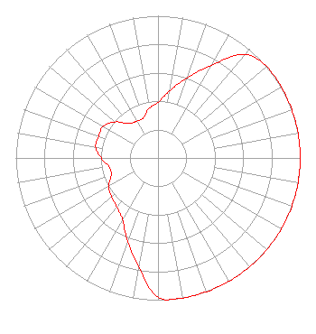 | ||||||||||||||||||
| Azimuth | Ratio | Azimuth | Ratio | Azimuth | Ratio | Azimuth | Ratio | ||||||||||||
| 0 | 0.390 | 10 | 0.480 | 20 | 0.600 | 30 | 0.755 | ||||||||||||
| 40 | 0.950 | 50 | 1.000 | 60 | 1.000 | 70 | 1.000 | ||||||||||||
| 80 | 1.000 | 90 | 1.000 | 100 | 1.000 | 110 | 1.000 | ||||||||||||
| 120 | 1.000 | 130 | 1.000 | 140 | 1.000 | 150 | 1.000 | ||||||||||||
| 160 | 1.000 | 170 | 1.000 | 180 | 0.980 | 190 | 0.780 | ||||||||||||
| 200 | 0.625 | 210 | 0.500 | 220 | 0.450 | 230 | 0.425 | ||||||||||||
| 240 | 0.400 | 250 | 0.350 | 260 | 0.350 | 270 | 0.400 | ||||||||||||
| 280 | 0.445 | 290 | 0.445 | 300 | 0.445 | 310 | 0.395 | ||||||||||||
| 320 | 0.315 | 330 | 0.300 | 340 | 0.300 | 350 | 0.355 | ||||||||||||
Structure Registration Number 1024089 Structure Type: TOWER Registered To: GEORGIA POWER COMPANY Structure Address: Substation, 0.4 Mi N Of Hwy 29, 1 Mi W Winder, GA County Name: Barrow County ASR Issued: 11/04/2020 Date Built: 11/05/2003 Site Elevation: 302.7 m (993 ft.) Structure Height: 106.7 m (350 ft.) Height Overall: 113.4 m (372 ft.) Overall Height AMSL: 416.1 m (1365 ft.) FAA Determination: 05/01/1998 FAA Study #: 97-ASO-2085-OE FAA Circular #: 70/7460-1J Paint & Light FAA Chapters: 4, 5, 6, 8, 13 33-59-46.8 N 83-45-18.2 W (NAD 83) 33-59-46.4 N 83-45-18.6 W (Converted to NAD 27) |
11530 Carmel Commons Boulevard Charlotte, NC 28226 Phone: 704-523-5555 Not-for-Profit | Title: Secretary-treasurer Date: 03/26/2024 Application Certifier BIBLE BROADCASTING NETWORK, INC. Bible Broadcasting Network, Inc. 11530 Carmel Commons Boulevard Charlotte, NC 28226 Applicant Justin Asher Asher Broadcast Consulting, Llc 579 Babcock Road Bronson, MI 49028-9347 Technical Consultant Gary S. Smithwick, Esquire Smithwick & Belendiuk, P.c. 5028 Wisconsin Avenue, N.w. Suite 301 Washington, DC 20016 Legal Counsel | |||||||||||||||||