
FCCInfo.com
A Service of Cavell, Mertz & Associates, Inc.
(855) FCC-INFO
|
|
W271DQ from 09/14/2022 W271DQ from 12/30/1997 |
|
|
||||||||||||||||
|
|
W271DQ Channel: 271D 102.1 MHz Baraboo, Wisconsin Service: FX - A translator or application for a translator. Facility ID: 86124 Fac. Service: FX Programming Delivery Method: Unspecified Status: Construction Permit Application Accepted: 03/19/2024 Application Granted: 04/04/2024 File Number: -0000241463 W271DQ CP Expires: 04/04/2027 Application Type: Minor Modification FCC Website Links: LMS Facility Details This Application Other W271DQ Applications Other W271DQ Applications in CDBS Including Superseded Applications Mailing Address Correspondence for W271DQ Correspondence related to application -0000241463 Service Contour - Open Street Map or USGS Map (60 dBu) Service Contour - KML / Google Earth (60 dBu) Facility Type: FM STATION Class: D, A Noncommercial educational operating with no more than 10W Site Location: 43-16-35.6 N 89-25-23.6 W (NAD 83) Site Location: 43-16-35.6 N 89-25-23.2 W (Converted to NAD 27) Effective Radiated Power: 0.2 kW Antenna Center HAAT: -22 m Horiz.; 0 m Vert. Antenna Center AMSL: 367.9 m (1207 ft.) Antenna Center HAG: 39.6 m (130 ft.) Site Elevation: 328.3 m. (1077 ft.) Height Overall*: 56.7 m (186 ft.) (* As Filed In This Application, may differ from ASR Data, Below.) Directional Antenna Antenna Make/Model: Nicom BKY3P-1DA(SLANT45) Antenna ID: 0 Polarization: H
| ||||||||||||||||||
| Antenna Data for Antenna Id: 0 W271DQ FX File: -0000241463 Nicom - BKY3P-1DA(SLANT45) Service: FX | 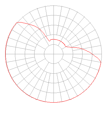 | ||||||||||||||||||
| Azimuth | Ratio | Azimuth | Ratio | Azimuth | Ratio | Azimuth | Ratio | ||||||||||||
| 0 | 0.300 | 10 | 0.300 | 20 | 0.300 | 30 | 0.300 | ||||||||||||
| 40 | 0.300 | 50 | 0.300 | 60 | 0.300 | 70 | 0.400 | ||||||||||||
| 80 | 0.600 | 90 | 0.800 | 100 | 1.000 | 110 | 1.000 | ||||||||||||
| 120 | 1.000 | 130 | 1.000 | 140 | 1.000 | 150 | 1.000 | ||||||||||||
| 160 | 1.000 | 170 | 1.000 | 180 | 1.000 | 190 | 1.000 | ||||||||||||
| 200 | 1.000 | 210 | 1.000 | 220 | 1.000 | 230 | 1.000 | ||||||||||||
| 240 | 1.000 | 250 | 1.000 | 260 | 1.000 | 270 | 1.000 | ||||||||||||
| 280 | 1.000 | 290 | 1.000 | 300 | 1.000 | 310 | 1.000 | ||||||||||||
| 320 | 0.800 | 330 | 0.600 | 340 | 0.300 | 350 | 0.300 | ||||||||||||
Structure Registration Number 1047789 Structure Type: LTOWER Registered To: UNITED STATES CELLULAR CORPORATION Structure Address: 7607 Patton Rd Deforest, WI County Name: Dane County ASR Issued: 12/29/2023 Date Built: 09/24/1990 Site Elevation: 328.3 m (1077 ft.) Structure Height: 54.9 m (180 ft.) Height Overall: 56.7 m (186 ft.) Overall Height AMSL: 385 m (1263 ft.) FAA Determination: 09/18/2023 FAA Study #: 2023-AGL-13851-OE Paint & Light FAA Chapters: NONE PRIOR STUDY 2022-AGL-1945-OE 43-16-35.6 N 89-25-23.6 W (NAD 83) 43-16-35.6 N 89-25-23.2 W (Converted to NAD 27) |
West Bend, WI 53095 Phone: 608-742-2544 Corporation | Title: President Date: 03/19/2024 Application Certifier MAGNUM COMMUNICATIONS, INC. Magnum Communications, Inc. West Bend, WI 53095 Applicant Justin Asher Asher Broadcast Consulting, Llc 579 Babcock Road Bronson, MI 49028 Technical Consultant John C Trent, Esq. Putbrese, Hunsaker And Trent, Pc 200 South Church Street Woodstock, VA 22664 | |||||||||||||||||