
FCCInfo.com
A Service of Cavell, Mertz & Associates, Inc.
(855) FCC-INFO
|
|
|
|
|
||||||||||||||||
|
|
Channel: 206C3 89.1 MHz Clinton, North Carolina Service: FM - A full-service FM station or application. Facility ID: 762611 Fac. Service: FM Status: Construction Permit Application Accepted: 03/15/2024 Application Granted: 03/26/2024 File Number: -0000241035 CP Expires: 01/25/2025 Application Type: Minor Modification FCC Website Links: LMS Facility Details This Application Other Applications Other Applications in CDBS Including Superseded Applications Mailing Address Correspondence for Correspondence related to application -0000241035 Service Contour - Open Street Map or USGS Map (60 dBu) Service Contour - KML / Google Earth (60 dBu) Facility Type: NON-COMMERCIAL EDUC. FM Class: C3, A Zone II station; with 6kW-25kW ERP and a class contour distance 28km-39km Site Location: 34-53-25.7 N 78-15-21.2 W (NAD 83) Site Location: 34-53-25.1 N 78-15-22.2 W (Converted to NAD 27) Effective Radiated Power: 13 kW Antenna Center HAAT: 58 m (190 ft.) Antenna Center AMSL: 88 m (289 ft.) Antenna Center HAG: 51 m (167 ft.) Site Elevation: 36.9 m. (121 ft.) Height Overall*: 78.6 m (258 ft.) (* As Filed In This Application, may differ from ASR Data, Below.) Directional Antenna Antenna Make/Model: None Antenna ID: 1006063 Polarization: | ||||||||||||||||||
| Antenna Data for Antenna Id: 1006063 FM File: -0000241035 None - Service: FM | 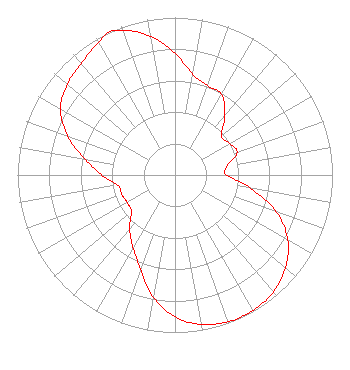 | ||||||||||||||||||
| Azimuth | Ratio | Azimuth | Ratio | Azimuth | Ratio | Azimuth | Ratio | ||||||||||||
| 0 | 0.771 | 10 | 0.648 | 20 | 0.604 | 30 | 0.590 | ||||||||||||
| 40 | 0.490 | 50 | 0.386 | 60 | 0.401 | 70 | 0.420 | ||||||||||||
| 80 | 0.337 | 90 | 0.327 | 100 | 0.488 | 110 | 0.687 | ||||||||||||
| 120 | 0.827 | 130 | 0.916 | 140 | 0.971 | 150 | 0.992 | ||||||||||||
| 160 | 0.991 | 170 | 0.964 | 180 | 0.900 | 190 | 0.790 | ||||||||||||
| 200 | 0.637 | 210 | 0.534 | 220 | 0.448 | 230 | 0.360 | ||||||||||||
| 240 | 0.351 | 250 | 0.359 | 260 | 0.370 | 270 | 0.465 | ||||||||||||
| 280 | 0.580 | 290 | 0.726 | 300 | 0.839 | 310 | 0.894 | ||||||||||||
| 320 | 0.926 | 330 | 0.970 | 335 | 1.000 | 340 | 0.976 | ||||||||||||
| 350 | 0.895 | ||||||||||||||||||
Structure Registration Number 1253962 Structure Type: TOWER Registered To: Crown Atlantic Company LLC Structure Address: 5551 Taylors Bridge Highway Clinton, NC County Name: Sampson County ASR Issued: 05/06/2016 Date Built: 07/06/2006 Site Elevation: 36.9 m (121 ft.) Structure Height: 60.9 m (200 ft.) Height Overall: 78.6 m (258 ft.) Overall Height AMSL: 115.5 m (379 ft.) FAA Determination: 04/26/2006 FAA Study #: 2006-ASO-2417-OE FAA Circular #: 70/7460-1K Paint & Light FAA Chapters: 4, 8, 12 PRIOR STUDY 2003-ASO-1248-OE 34-53-25.7 N 78-15-21.2 W (NAD 83) 34-53-25.1 N 78-15-22.2 W (Converted to NAD 27) |
Po Box 1895 Goldsboro, NC 27533 Phone: 252-939-0484 Private Not-for-Profit Educational Institution | Title: President Date: 03/15/2024 Application Certifier Pathway Christian Academy, Inc. Po Box 1895 Goldsboro, NC 27533 Applicant Charles Burkhart Sterling Communications, Inc. Po Box 1877 Lafayette, GA 30728 Technical Consultant James E Price, III Sterling Communications, Inc. Po Box 1877 Lafayette, GA 30728 Legal Representative | |||||||||||||||||