
FCCInfo.com
A Service of Cavell, Mertz & Associates, Inc.
(855) FCC-INFO
|
|
|
|
|
||||||||||||||||
|
|
KOKF Channel: 215C1 90.9 MHz Edmond, Oklahoma Service: FS - A full service FM station auxiliary transmitting antenna or application. Facility ID: 54418 Fac. Service: FM Status: Construction Permit Application Accepted: 03/15/2024 Application Granted: 04/10/2024 File Number: -0000240907 KOKF CP Expires: 04/10/2027 Application Type: Construction Permit FCC Website Links: LMS Facility Details This Application Other KOKF Applications Other KOKF Applications in CDBS Including Superseded Applications Mailing Address Correspondence for KOKF Correspondence related to application -0000240907 Service Contour - Open Street Map or USGS Map (60 dBu) Service Contour - KML / Google Earth (60 dBu) Public Inspection Files History Cards for KOKF Facility Type: NON-COMMERCIAL EDUC. FM Class: C1, A Zone II station; with 50kW-100kW ERP and a class contour distance 52km-72km Site Location: 35-34-24.4 N 97-29-09.5 W (NAD 83) Site Location: 35-34-24.2 N 97-29-08.4 W (Converted to NAD 27) Effective Radiated Power: 13.5 kW Antenna Center HAAT: 204.7 m (672 ft.) Antenna Center AMSL: 554.7 m (1820 ft.) Antenna Center HAG: 195 m (640 ft.) Site Elevation: 359.7 m. (1180 ft.) Height Overall*: 260 m (853 ft.) (* As Filed In This Application, may differ from ASR Data, Below.) Directional Antenna Antenna Make/Model: None Antenna ID: 69-2019-08-06 Polarization: | ||||||||||||||||||
| Antenna Data for Antenna Id: 69-2019-08-06 KOKF FS File: -0000240907 None - Service: FS | 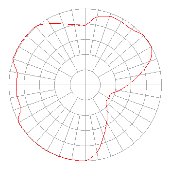 | ||||||||||||||||||
| Azimuth | Ratio | Azimuth | Ratio | Azimuth | Ratio | Azimuth | Ratio | ||||||||||||
| 0 | 0.780 | 10 | 0.900 | 20 | 0.950 | 30 | 0.950 | ||||||||||||
| 40 | 0.950 | 50 | 1.000 | 60 | 1.000 | 70 | 0.899 | ||||||||||||
| 80 | 0.714 | 90 | 0.568 | 100 | 0.451 | 110 | 0.358 | ||||||||||||
| 120 | 0.358 | 130 | 0.358 | 140 | 0.451 | 150 | 0.568 | ||||||||||||
| 160 | 0.714 | 170 | 0.899 | 180 | 1.000 | 190 | 1.000 | ||||||||||||
| 200 | 1.000 | 210 | 1.000 | 220 | 1.000 | 230 | 1.000 | ||||||||||||
| 240 | 1.000 | 250 | 0.900 | 260 | 0.900 | 270 | 0.900 | ||||||||||||
| 280 | 0.900 | 290 | 1.000 | 300 | 1.000 | 310 | 1.000 | ||||||||||||
| 320 | 1.000 | 330 | 0.925 | 340 | 0.850 | 350 | 0.800 | ||||||||||||
Structure Registration Number 1012601 Structure Type: Registered To: UNIVERSITY OF CENTRAL OKLAHOMA Structure Address: 1501 Ne 101 St Oklahoma City, OK County Name: Oklahoma County ASR Issued: 06/08/2023 Date Built: 04/04/1997 Site Elevation: 359.7 m (1180 ft.) Structure Height: 259.1 m (850 ft.) Height Overall: 260 m (853 ft.) Overall Height AMSL: 619.7 m (2033 ft.) FAA Determination: 10/14/1997 FAA Study #: 97-ASW-2228-OE FAA Circular #: 70/7460-1J Paint & Light FAA Chapters: 3, 4, 5, 13 Removed expiration and final dates from determination. Scenario 2./jjs/case#635066 35-34-24.4 N 97-29-09.5 W (NAD 83) 35-34-24.2 N 97-29-08.4 W (Converted to NAD 27) |
5700 West Oaks Blvd. Rocklin, CA 95765 Phone: 916-251-1600 Not-for-Profit | Title: Chief Financial Officer Date: 03/15/2024 Application Certifier EDUCATIONAL MEDIA FOUNDATION Educational Media Foundation 5700 West Oaks Blvd. Rocklin, CA 95765 Applicant LINDA ADAMS Educational Media Foundation 5700 West Oaks Blvd Rocklin, CA 95765 MARY O'CONNOR Wilkinson Barker Knauer, Llp 1800 M. Street, Nw Suite 800n Washington, DC 20036 | |||||||||||||||||