
FCCInfo.com
A Service of Cavell, Mertz & Associates, Inc.
(855) FCC-INFO
|
|
W266BW from 02/12/2004 |
|
|
||||||||||||||||
|
|
W266BW Channel: 266D 101.1 MHz Winder, Georgia Service: FX - A translator or application for a translator. Facility ID: 147273 Fac. Service: FX Programming Delivery Method: Unspecified Status: Construction Permit Application Accepted: 03/27/2024 Application Pending: 03/27/2024 File Number: -0000242401 W266BW CP Expires: 04/01/2028 Application Type: Minor Modification FCC Website Links: LMS Facility Details This Application Other W266BW Applications Other W266BW Applications in CDBS Including Superseded Applications Mailing Address Correspondence for W266BW Correspondence related to application -0000242401 Service Contour - Open Street Map or USGS Map (60 dBu) Service Contour - KML / Google Earth (60 dBu) Facility Type: FM STATION Class: D, A Noncommercial educational operating with no more than 10W Site Location: 33-48-26.4 N 84-20-21.5 W (NAD 83) Site Location: 33-48-26.0 N 84-20-21.8 W (Converted to NAD 27) Effective Radiated Power: 0.25 kW Antenna Center HAAT: 0 m Antenna Center AMSL: 555 m (1821 ft.) Antenna Center HAG: 290.7 m (954 ft.) Site Elevation: 264.3 m. (867 ft.) Height Overall*: 360.3 m (1182 ft.) (* As Filed In This Application, may differ from ASR Data, Below.) Directional Antenna Antenna Make/Model: Scala 3X-CL-FM/SRM/SV-45deg Antenna ID: 1011595 Polarization: H
| ||||||||||||||||||
| Antenna Data for Antenna Id: 1011595 W266BW FX File: -0000242401 Scala - 3X-CL-FM/SRM/SV-45deg Service: FX | 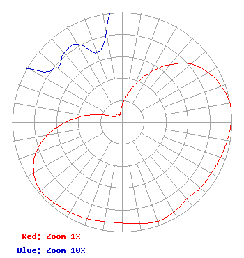 | ||||||||||||||||||
| Azimuth | Ratio | Azimuth | Ratio | Azimuth | Ratio | Azimuth | Ratio | ||||||||||||
| 0 | 0.147 | 10 | 0.240 | 20 | 0.367 | 30 | 0.526 | ||||||||||||
| 40 | 0.683 | 50 | 0.823 | 60 | 0.904 | 70 | 0.961 | ||||||||||||
| 80 | 0.997 | 83 | 1.000 | 90 | 0.994 | 100 | 0.973 | ||||||||||||
| 110 | 0.953 | 120 | 0.936 | 130 | 0.934 | 140 | 0.917 | ||||||||||||
| 150 | 0.948 | 160 | 0.960 | 170 | 0.940 | 180 | 0.920 | ||||||||||||
| 190 | 0.920 | 200 | 0.936 | 210 | 0.950 | 220 | 0.960 | ||||||||||||
| 230 | 0.970 | 240 | 0.927 | 250 | 0.838 | 260 | 0.690 | ||||||||||||
| 270 | 0.512 | 280 | 0.336 | 290 | 0.196 | 300 | 0.097 | ||||||||||||
| 310 | 0.077 | 320 | 0.082 | 330 | 0.082 | 340 | 0.067 | ||||||||||||
| 350 | 0.083 | ||||||||||||||||||
Structure Registration Number 1223132 Structure Type: GTOWER Registered To: American Towers LLC Structure Address: 1800 Briarcliff Road Ne (#282650) Atlanta, GA County Name: DeKalb County ASR Issued: 07/11/2023 Date Built: 03/27/2002 Site Elevation: 264.3 m (867 ft.) Structure Height: 321.9 m (1056 ft.) Height Overall: 360.3 m (1182 ft.) Overall Height AMSL: 624.6 m (2049 ft.) FAA Determination: 11/02/2021 FAA Study #: 2021-ASO-36490-OE FAA Circular #: 70/7460-1M Paint & Light FAA Chapters: 4, 9, 15 33-48-26.4 N 84-20-21.5 W (NAD 83) 33-48-26.0 N 84-20-21.8 W (Converted to NAD 27) |
2203 Wynnton Road Columbus, GA 31902 Phone: 706-576-5360 Limited Liability Company | Title: Sole Member And Manager Date: 03/27/2024 Application Certifier DAVIS BROADCASTING OF ATLANTA, L.L.C. Davis Broadcasting Of Atlanta, L.l.c. 2203 Wynnton Road Columbus, GA 31902 Applicant Bert S Goldman Goldman Engineering Management 560 Perkins Way Auburn, CA 95603 Technical Consultant F. SCOTT PIPPIN Lerman Senter Pllc 2001 L Street, N.w. Suite 400 Washington, DC 20036 ATTORNEY | |||||||||||||||||