
FCCInfo.com
A Service of Cavell, Mertz & Associates, Inc.
(855) FCC-INFO
|
|
|
|
|
||||||||||||||||
|
|
WTUL Channel: 218A 91.5 MHz New Orleans, Louisiana Service: FM - A full-service FM station or application. Facility ID: 68321 Fac. Service: FM Status: License Application Accepted: 04/09/2024 Application Granted: 04/19/2024 File Number: -0000243290 License Expires: 06/01/2028 Application Type: License To Cover FCC Website Links: LMS Facility Details This Application Other WTUL Applications Other WTUL Applications in CDBS Including Superseded Applications Mailing Address Correspondence for WTUL Correspondence related to application -0000243290 Service Contour - Open Street Map or USGS Map (60 dBu) Service Contour - KML / Google Earth (60 dBu) Public Inspection Files History Cards for WTUL Facility Type: NON-COMMERCIAL EDUC. FM Class: A, A Zone I; I-A; or II station; with 0.1kW-6kW ERP and a class contour distance <=28km Site Location: 29-57-25.7 N 90-04-31.2 W (NAD 83) Site Location: 29-57-25.0 N 90-04-30.9 W (Converted to NAD 27) Effective Radiated Power: 0.95 kW Antenna Center HAAT: 121 m (397 ft.) Antenna Center AMSL: 121 m (397 ft.) Antenna Center HAG: 120 m (394 ft.) Site Elevation: 1.2 m. (4 ft.) Height Overall*: 140.5 m (461 ft.) (* As Filed In This Application, may differ from ASR Data, Below.) Directional Antenna Antenna Make/Model: Systems With Reliability Inc. FM3/2-HWS-DA, 2 sections Antenna ID: 0 Polarization: H | ||||||||||||||||||
| Antenna Data for Antenna Id: 0 WTUL FM File: -0000243290 Systems With Reliability Inc. - FM3/2-HWS-DA, 2 sections Service: FM | 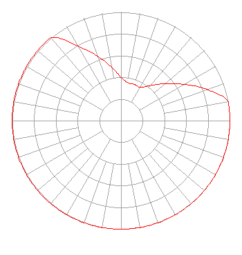 | ||||||||||||||||||
| Azimuth | Ratio | Azimuth | Ratio | Azimuth | Ratio | Azimuth | Ratio | ||||||||||||
| 0 | 0.398 | 10 | 0.355 | 20 | 0.355 | 30 | 0.355 | ||||||||||||
| 40 | 0.422 | 50 | 0.531 | 60 | 0.668 | 70 | 0.841 | ||||||||||||
| 80 | 1.000 | 90 | 1.000 | 100 | 1.000 | 110 | 1.000 | ||||||||||||
| 120 | 1.000 | 130 | 1.000 | 140 | 1.000 | 150 | 1.000 | ||||||||||||
| 160 | 1.000 | 170 | 1.000 | 180 | 1.000 | 190 | 1.000 | ||||||||||||
| 200 | 1.000 | 210 | 1.000 | 220 | 1.000 | 230 | 1.000 | ||||||||||||
| 240 | 1.000 | 250 | 1.000 | 260 | 1.000 | 270 | 1.000 | ||||||||||||
| 280 | 1.000 | 290 | 1.000 | 300 | 1.000 | 310 | 1.000 | ||||||||||||
| 320 | 1.000 | 330 | 0.794 | 340 | 0.631 | 350 | 0.501 | ||||||||||||
Structure Registration Number 1203308 Structure Type: BMAST Registered To: Tulane University Structure Address: 1440 Canal Street New Orleans, LA County Name: Orleans Parish ASR Issued: 03/12/2024 Date Built: 02/27/2023 Site Elevation: 1.2 m (4 ft.) Structure Height: 95.1 m (312 ft.) Height Overall: 140.5 m (461 ft.) Overall Height AMSL: 141.7 m (465 ft.) FAA Determination: 12/15/2022 FAA Study #: 2022-ASW-20787-OE Paint & Light FAA Chapters: 1, 3, 4, 13, 21 PRIOR STUDY 2012-ASW-1145-OE 29-57-24.3 N 90-04-32.8 W (NAD 83) 29-57-23.6 N 90-04-32.5 W (Converted to NAD 27) |
G07 Lavin-bernik Ctr. Attn: Wtul 29 Mcalister Drive New Orleans, LA 70118 Phone: 504-865-5738 Private Not-for-Profit Educational Institution | Title: Director Of The Lavin-bernick Center For University Life Date: 04/09/2024 Application Certifier TULANE EDUCATIONAL FUND Tulane Educational Fund G07 Lavin-bernik Ctr. Attn: Wtul 29 Mcalister Drive New Orleans, LA 70118 Applicant Mark A. Balkin Hardy, Carey, Chautin & Balkin, L.l.p. 1080 West Causeway Approach Mandeville, LA 70471 Gray Frierson Haertig Gray Frierson Haertig & Assoc. 4646 S.w. Council Crest Drive Portland, OR 97239 Engineering Counsel | |||||||||||||||||
| |||||||||||||||||||