
FCCInfo.com
A Service of Cavell, Mertz & Associates, Inc.
(855) FCC-INFO
|
|
|
|  |
|
|||||||||||||||
|
|
WVPG Channel: 212B1 90.3 MHz Parkersburg, West Virginia Service: FM - A full-service FM station or application. Facility ID: 70642 Fac. Service: FM Analog & Digital Status: Construction Permit Application Accepted: 04/16/2024 Application Pending: 04/16/2024 File Number: -0000243577 WVPG CP Expires: 00/00/0000 Application Type: Minor Modification FCC Website Links: LMS Facility Details This Application Other WVPG Applications Other WVPG Applications in CDBS Including Superseded Applications Mailing Address Correspondence for WVPG Correspondence related to application -0000243577 Service Contour - Open Street Map or USGS Map (60 dBu) Service Contour - KML / Google Earth (60 dBu) Public Inspection Files Facility Type: NON-COMMERCIAL EDUC. FM Class: B1, A Zone I or I-A station; with 6kW-25kW ERP and a class contour distance 28km-39km Site Location: 39-14-48.1 N 81-25-01.0 W (NAD 83) Site Location: 39-14-47.8 N 81-25-01.6 W (Converted to NAD 27) Effective Radiated Power: 10.5 kW Antenna Center HAAT: 154 m (505 ft.) Antenna Center AMSL: 399 m (1309 ft.) Antenna Center HAG: 87.2 m (286 ft.) Site Elevation: 311.8 m. (1023 ft.) Height Overall*: 97.5 m (320 ft.) (* As Filed In This Application, may differ from ASR Data, Below.) Directional Antenna Antenna Make/Model: None Antenna ID: 1006063 Polarization:
| ||||||||||||||||||
| Antenna Data for Antenna Id: 1006063 WVPG FM File: -0000243577 None - Service: FM | 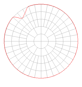 | ||||||||||||||||||
| Azimuth | Ratio | Azimuth | Ratio | Azimuth | Ratio | Azimuth | Ratio | ||||||||||||
| 0 | 1.000 | 10 | 1.000 | 20 | 1.000 | 30 | 1.000 | ||||||||||||
| 40 | 1.000 | 50 | 1.000 | 60 | 1.000 | 70 | 1.000 | ||||||||||||
| 80 | 1.000 | 90 | 1.000 | 100 | 1.000 | 110 | 1.000 | ||||||||||||
| 120 | 1.000 | 130 | 1.000 | 140 | 1.000 | 150 | 1.000 | ||||||||||||
| 160 | 1.000 | 170 | 1.000 | 180 | 1.000 | 190 | 1.000 | ||||||||||||
| 200 | 1.000 | 210 | 1.000 | 220 | 1.000 | 230 | 1.000 | ||||||||||||
| 240 | 1.000 | 250 | 1.000 | 260 | 1.000 | 270 | 1.000 | ||||||||||||
| 280 | 1.000 | 290 | 1.000 | 300 | 1.000 | 310 | 1.000 | ||||||||||||
| 320 | 0.809 | 330 | 0.870 | 340 | 1.000 | 350 | 1.000 | ||||||||||||
Structure Registration Number 1282649 Structure Type: LTOWER Registered To: West Virginia Emergency Management Division Structure Address: 314 Benn Lake Road Parkersburg, WV County Name: Wood County ASR Issued: 01/17/2024 Date Built: 06/20/2013 Site Elevation: 311.8 m (1023 ft.) Structure Height: 91.4 m (300 ft.) Height Overall: 97.5 m (320 ft.) Overall Height AMSL: 409.3 m (1343 ft.) FAA Determination: 01/23/2012 FAA Study #: 2011-AEA-5057-OE FAA Circular #: 70/7460-1K Paint & Light FAA Chapters: 4, 8, 12 Removed expiration date from determination. Scenario 1./jjs/case#635066 39-14-48.1 N 81-25-01.0 W (NAD 83) 39-14-47.8 N 81-25-01.6 W (Converted to NAD 27) |
600 Capitol Street Charleston, WV 25301 Phone: 304-556-4912 Government Entity | Title: Interim Executive Director Date: 04/16/2024 Application Certifier WEST VIRGINIA EDUCATIONAL BROADCASTING AUTHORITY West Virginia Educational Broadcasting Authority 600 Capitol Street Charleston, WV 25301 Applicant Virginia Hiner Akin Gump Strauss Hauer & Feld Llp 2001 K St Nw Washington, DC 20006 Counsel Ryan C Wilhour Kessler And Gehman Associates, Inc. 14260 W Newberry Road #412 Newberry, FL 32669 Consulting Engineer | |||||||||||||||||