
FCCInfo.com
A Service of Cavell, Mertz & Associates, Inc.
(855) FCC-INFO
|
|
KVLW from 04/17/1997 |
|
|
||||||||||||||||
|
|
KVLW Channel: 201C1 88.1 MHz Gatesville, Texas Service: FM - A full-service FM station or application. Facility ID: 86324 Fac. Service: FM Status: Construction Permit Application Accepted: 05/02/2024 Application Granted: 05/07/2024 File Number: -0000244268 KVLW CP Expires: 05/07/2027 Application Type: Minor Modification FCC Website Links: LMS Facility Details This Application Other KVLW Applications Other KVLW Applications in CDBS Including Superseded Applications Mailing Address Correspondence for KVLW Correspondence related to application -0000244268 Service Contour - Open Street Map or USGS Map (60 dBu) Service Contour - KML / Google Earth (60 dBu) Public Inspection Files Facility Type: NON-COMMERCIAL EDUC. FM Class: C1, A Zone II station; with 50kW-100kW ERP and a class contour distance 52km-72km Site Location: 31-18-53.6 N 97-19-37.1 W (NAD 83) Site Location: 31-18-53.0 N 97-19-36.1 W (Converted to NAD 27) Effective Radiated Power: 0 kW Horiz. ; 17 kW Vert. Antenna Center HAAT: 0 m Horiz.; 330 m Vert. Antenna Center AMSL: 0 m Horiz.; 537 m Vert. Antenna Center HAG: 0 m Horiz.; 285 m Vert. Site Elevation: 252.1 m. (827 ft.) Height Overall*: 522.4 m (1714 ft.) (* As Filed In This Application, may differ from ASR Data, Below.) Directional Antenna Antenna Make/Model: None Antenna ID: 78446 Polarization:
| ||||||||||||||||||
| Antenna Data for Antenna Id: 78446 KVLW FM File: -0000244268 None - Service: FM | 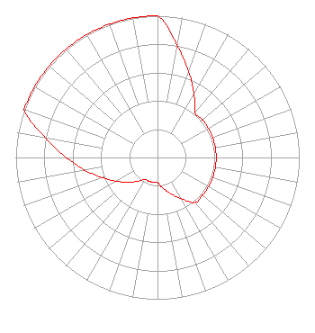 | ||||||||||||||||||
| Azimuth | Ratio | Azimuth | Ratio | Azimuth | Ratio | Azimuth | Ratio | ||||||||||||
| 0 | 1.000 | 10 | 0.802 | 20 | 0.644 | 30 | 0.516 | ||||||||||||
| 40 | 0.414 | 50 | 0.414 | 60 | 0.414 | 70 | 0.414 | ||||||||||||
| 80 | 0.414 | 90 | 0.414 | 100 | 0.414 | 110 | 0.414 | ||||||||||||
| 120 | 0.414 | 130 | 0.414 | 140 | 0.414 | 150 | 0.335 | ||||||||||||
| 160 | 0.271 | 170 | 0.220 | 180 | 0.178 | 190 | 0.178 | ||||||||||||
| 200 | 0.178 | 210 | 0.178 | 220 | 0.220 | 230 | 0.271 | ||||||||||||
| 240 | 0.335 | 250 | 0.414 | 260 | 0.516 | 270 | 0.644 | ||||||||||||
| 280 | 0.802 | 290 | 1.000 | 300 | 1.000 | 310 | 1.000 | ||||||||||||
| 320 | 1.000 | 330 | 1.000 | 340 | 1.000 | 350 | 1.000 | ||||||||||||
Structure Registration Number 1059337 Structure Type: TOWER Registered To: Pinnacle Towers LLC Structure Address: 1.5 Mi Ne Moody, TX County Name: McLennan County ASR Issued: 05/06/2016 Date Built: 01/01/1988 Site Elevation: 252.1 m (827 ft.) Structure Height: 504.7 m (1656 ft.) Height Overall: 522.4 m (1714 ft.) Overall Height AMSL: 774.5 m (2541 ft.) FAA Determination: 10/28/2011 FAA Study #: 2011-ASW-4071-OE Paint & Light FAA Chapters: B, F, H Continue As Is OM&L = 24-HR HI-STROBES 31-18-53.6 N 97-19-37.1 W (NAD 83) 31-18-53.0 N 97-19-36.1 W (Converted to NAD 27) |
5700 West Oaks Blvd Rocklin, CA 95765 Phone: 916-251-1600 Not-for-Profit | Title: Chief Financial Officer Date: 05/02/2024 Application Certifier EDUCATIONAL MEDIA FOUNDATION Educational Media Foundation 5700 West Oaks Blvd Rocklin, CA 95765 Applicant MARY N O'CONNOR Wilkinson Barker Knauer, Llp 1800 M. Street, Nw, Suite 800n Washington, DC 20036 LINDA ADAMS Educational Media Foundation 5700 West Oaks Blvd Rocklin, CA 95765 | |||||||||||||||||