
FCCInfo.com
A Service of Cavell, Mertz & Associates, Inc.
(855) FCC-INFO
|
|
W269DV from 08/09/2004 |
|
|
||||||||||||||||
|
|
W269DV Channel: 269D 101.7 MHz Beckley, West Virginia Service: FX - A translator or application for a translator. Facility ID: 157019 Fac. Service: FX Programming Delivery Method: Unspecified Status: License Application Accepted: 11/22/2019 Application Granted: 01/10/2020 File Number: -0000090816 License Expires: 10/01/2027 Application Type: License To Cover FCC Website Links: LMS Facility Details This Application Other W269DV Applications Other W269DV Applications in CDBS Including Superseded Applications Mailing Address Correspondence for W269DV Correspondence related to application -0000090816 Service Contour - Open Street Map or USGS Map (60 dBu) Service Contour - KML / Google Earth (60 dBu) Facility Type: FM STATION Class: D, A Noncommercial educational operating with no more than 10W Site Location: 37-47-13.4 N 81-06-49.4 W (NAD 83) Site Location: 37-47-13.0 N 81-06-50.0 W (Converted to NAD 27) Effective Radiated Power: 0.25 kW Antenna Center HAAT: 0 m Antenna Center AMSL: 796 m (2612 ft.) Antenna Center HAG: 40 m (131 ft.) Site Elevation: 756 m. (2480 ft.) Height Overall*: 40 m (131 ft.) (* As Filed In This Application, may differ from ASR Data, Below.) Directional Antenna Antenna Make/Model: Nicom BKG/77 Antenna ID: 135169 Polarization: H
| ||||||||||||||||||
| Antenna Data for Antenna Id: 135169 W269DV FX File: -0000090816 Nicom - BKG/77 Service: FX Pattern and Field Values Include a 90° Clockwise Rotation | 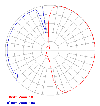 | ||||||||||||||||||
| Azimuth | Ratio | Azimuth | Ratio | Azimuth | Ratio | Azimuth | Ratio | ||||||||||||
| 0 | 0.800 | 10 | 1.000 | 20 | 1.000 | 30 | 1.000 | ||||||||||||
| 40 | 1.000 | 50 | 1.000 | 60 | 1.000 | 70 | 1.000 | ||||||||||||
| 80 | 1.000 | 90 | 1.000 | 100 | 1.000 | 110 | 1.000 | ||||||||||||
| 120 | 1.000 | 130 | 1.000 | 140 | 1.000 | 150 | 1.000 | ||||||||||||
| 160 | 1.000 | 170 | 0.800 | 180 | 0.300 | 190 | 0.200 | ||||||||||||
| 200 | 0.150 | 210 | 0.150 | 220 | 0.150 | 230 | 0.095 | ||||||||||||
| 240 | 0.095 | 250 | 0.095 | 260 | 0.095 | 270 | 0.095 | ||||||||||||
| 280 | 0.095 | 290 | 0.095 | 300 | 0.095 | 310 | 0.095 | ||||||||||||
| 320 | 0.095 | 330 | 0.095 | 340 | 0.095 | 350 | 0.095 | ||||||||||||
Structure Registration Number 1257714 Structure Type: TOWER Registered To: RALEIGH CO EMERGENCY SERVICES/911 Structure Address: 162 Industrial Park Rd Beaver, WV County Name: Raleigh County ASR Issued: 03/23/2007 Date Built: 05/15/2007 Site Elevation: 755.9 m (2480 ft.) Structure Height: 39.6 m (130 ft.) Height Overall: 39.6 m (130 ft.) Overall Height AMSL: 795.5 m (2610 ft.) FAA Determination: 06/30/2005 FAA Study #: 2005-AEA-1421-OE FAA Circular #: 70/7460-1K Paint & Light FAA Chapters: 4, 5, 12 PRIOR STUDY 2001-AEA-4466-OE 37-47-13.7 N 81-06-49.5 W (NAD 83) 37-47-13.3 N 81-06-50.1 W (Converted to NAD 27) |
Edmond, WV 25837 Phone: 304-222-5062 Individual | Title: Owner Date: 11/22/2019 Application Certifier CHRISTI LILLY 55 New Ground Road Edmond, WV 25837 Applicant CHRISTI LILLY Christi Lilly 55 New Ground Road Edmond, WV 25837 ROBERT J. Robbins Robert J. Robbins Radio Data Services 20808 Sw 83 Ave Cutler Bay, FL 33189 CONSULTANT | |||||||||||||||||