
FCCInfo.com
A Service of Cavell, Mertz & Associates, Inc.
(855) FCC-INFO
|
|
|
|
|
||||||||||||||||
|
|
WLAV-FM Channel: 245B 96.9 MHz Grand Rapids, Michigan Service: FM - A full-service FM station or application. Facility ID: 41680 Fac. Service: FM Analog & Digital Status: License 73.215 Station Application Accepted: 01/31/2020 Application Granted: 02/14/2020 File Number: -0000103671 License Expires: 10/01/2020 Application Type: License To Cover FCC Website Links: LMS Facility Details This Application Other WLAV-FM Applications Other WLAV-FM Applications in CDBS Including Superseded Applications Mailing Address Correspondence for WLAV-FM Correspondence related to application -0000103671 Service Contour - Open Street Map or USGS Map (54 dBu) Service Contour - KML / Google Earth (54 dBu) Public Inspection Files History Cards for WLAV-FM Facility Type: FM STATION Class: B, A Zone I or I-A station; with 25kW-50kW ERP and a class contour distance 39km-52km Site Location: 42-57-34.7 N 85-53-44.9 W (NAD 83) Site Location: 42-57-34.6 N 85-53-44.8 W (Converted to NAD 27) Effective Radiated Power: 43 kW Antenna Center HAAT: 160 m (525 ft.) Antenna Center AMSL: 365 m (1198 ft.) Antenna Center HAG: 156 m (512 ft.) Calculated Site Elevation: 209 m. (686 ft.) Height Overall*: 261.5 m (858 ft.) (* As Filed In This Application, may differ from ASR Data, Below.) Directional Antenna Antenna Make/Model: Shively 6016-2/3-DA,2bays Antenna ID: 134775 Polarization: H | ||||||||||||||||||
| Antenna Data for Antenna Id: 134775 WLAV-FM FM File: -0000103671 Shively - 6016-2/3-DA,2bays Service: FM | 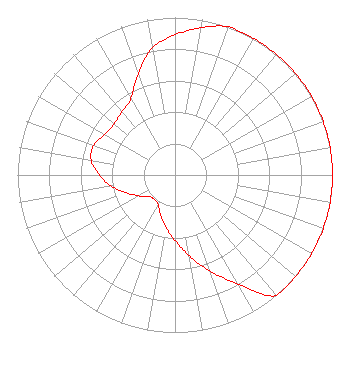 | ||||||||||||||||||
| Azimuth | Ratio | Azimuth | Ratio | Azimuth | Ratio | Azimuth | Ratio | ||||||||||||
| 0 | 0.890 | 10 | 0.950 | 20 | 1.000 | 30 | 1.000 | ||||||||||||
| 40 | 1.000 | 50 | 1.000 | 60 | 1.000 | 70 | 1.000 | ||||||||||||
| 80 | 1.000 | 90 | 1.000 | 100 | 1.000 | 110 | 1.000 | ||||||||||||
| 120 | 1.000 | 130 | 1.000 | 140 | 1.000 | 150 | 0.800 | ||||||||||||
| 160 | 0.651 | 170 | 0.520 | 180 | 0.416 | 190 | 0.334 | ||||||||||||
| 200 | 0.268 | 210 | 0.215 | 220 | 0.203 | 230 | 0.213 | ||||||||||||
| 240 | 0.265 | 250 | 0.330 | 260 | 0.410 | 270 | 0.482 | ||||||||||||
| 280 | 0.541 | 290 | 0.550 | 300 | 0.515 | 310 | 0.505 | ||||||||||||
| 320 | 0.525 | 330 | 0.559 | 340 | 0.686 | 350 | 0.820 | ||||||||||||
Structure Registration Number 1005721 [ASR Heights Differ from WLAV-FM Application] Structure Type: GTOWER Registered To: GRAND VALLEY STATE UNIVERSITY Structure Address: Pierce Rd & 48th Ave Allendale, MI County Name: Ottawa County ASR Issued: 03/14/2024 Date Built: 10/08/2020 Site Elevation: 209.7 m (688 ft.) Structure Height: 244.7 m (803 ft.) Height Overall: 261.5 m (858 ft.) Overall Height AMSL: 471.2 m (1546 ft.) FAA Determination: 10/06/2020 FAA Study #: 2020-AGL-16087-OE FAA Circular #: 70/7460-1L Paint & Light FAA Chapters: 3, 4, 5, 12 42-57-34.7 N 85-53-44.9 W (NAD 83) 42-57-34.6 N 85-53-44.8 W (Converted to NAD 27) |
780 Johnson Ferry Road Suite 500 Atlanta, GA 30342 Phone: 404-949-0700 Limited Liability Company | Title: Executive Vice President And General Counsel Date: 01/31/2020 Application Certifier RADIO LICENSE HOLDING CBC, LLC Radio License Holding Cbc, Llc 3280 Peachtree Road, Nw Suite 2200 Atlanta, GA 30305 Applicant Mark Lipp Fletcher Heald & Hildreth Plc 1300 N. 17th Street Suite 1100 Arlington, VA 22209 Attorney William J. Getz Carl T. Jones Corporation 7901 Yarnwood Ct Springfield, VA 22153 Consulting Engineer | |||||||||||||||||
|
| ||||||||||||||||||