
FCCInfo.com
A Service of Cavell, Mertz & Associates, Inc.
(855) FCC-INFO
|
|
W236CU from 10/07/2003 |
|
|
||||||||||||||||
|
|
W236CU Channel: 236D 95.1 MHz Lowell, Massachusetts Service: FX - A translator or application for a translator. Facility ID: 139030 Fac. Service: FX Programming Delivery Method: Unspecified Status: License Application Accepted: 05/27/2020 Application Granted: 05/29/2020 File Number: -0000114519 License Expires: 04/01/2022 Application Type: License To Cover FCC Website Links: LMS Facility Details This Application Other W236CU Applications Other W236CU Applications in CDBS Including Superseded Applications Mailing Address Correspondence for W236CU Correspondence related to application -0000114519 Service Contour - Open Street Map or USGS Map (60 dBu) Service Contour - KML / Google Earth (60 dBu) Facility Type: FM STATION Class: D, A Noncommercial educational operating with no more than 10W Site Location: 42-39-14.0 N 71-13-00.0 W (NAD 83) Site Location: 42-39-13.7 N 71-13-01.8 W (Converted to NAD 27) Effective Radiated Power: 0.17 kW Transmitter Output Power: 0.026 kW Antenna Center HAAT: 0 m Antenna Center AMSL: 200.6 m (658 ft.) Antenna Center HAG: 100 m (328 ft.) Site Elevation: 100.6 m. (330 ft.) Height Overall*: 145.4 m (477 ft.) (* As Filed In This Application, may differ from ASR Data, Below.) Directional Antenna Antenna Make/Model: SCALA CA5-FM-CP Antenna ID: 127299 Polarization: H
| ||||||||||||||||||
| Antenna Data for Antenna Id: 127299 W236CU FX File: -0000114519 SCALA - CA5-FM-CP Service: FX | 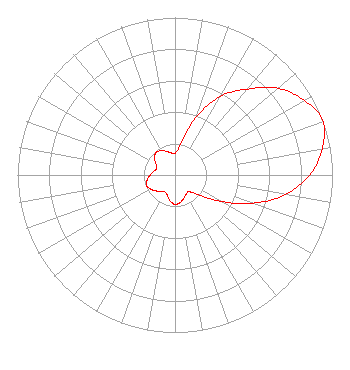 | ||||||||||||||||||
| Azimuth | Ratio | Azimuth | Ratio | Azimuth | Ratio | Azimuth | Ratio | ||||||||||||
| 0 | 0.138 | 10 | 0.194 | 20 | 0.387 | 30 | 0.578 | ||||||||||||
| 40 | 0.712 | 50 | 0.855 | 60 | 0.948 | 70 | 1.000 | ||||||||||||
| 80 | 0.948 | 90 | 0.855 | 100 | 0.712 | 110 | 0.525 | ||||||||||||
| 120 | 0.335 | 130 | 0.194 | 140 | 0.138 | 150 | 0.142 | ||||||||||||
| 160 | 0.160 | 170 | 0.179 | 180 | 0.186 | 190 | 0.169 | ||||||||||||
| 200 | 0.139 | 210 | 0.125 | 220 | 0.136 | 230 | 0.157 | ||||||||||||
| 240 | 0.179 | 250 | 0.193 | 260 | 0.179 | 270 | 0.157 | ||||||||||||
| 280 | 0.136 | 290 | 0.125 | 300 | 0.139 | 310 | 0.169 | ||||||||||||
| 320 | 0.186 | 330 | 0.179 | 340 | 0.160 | 350 | 0.142 | ||||||||||||
Structure Registration Number 1036205 Structure Type: GTOWER Registered To: American Towers LLC Structure Address: 149 Haggetts Pond Rd (203692) Andover, MA County Name: Essex County ASR Issued: 02/07/2024 Date Built: 07/17/1998 Site Elevation: 100.6 m (330 ft.) Structure Height: 130.5 m (428 ft.) Height Overall: 145.4 m (477 ft.) Overall Height AMSL: 246 m (807 ft.) FAA Determination: 04/20/2023 FAA Study #: 2022-ANE-5340-OE FAA Circular #: 70/7460-1L Paint & Light FAA Chapters: 4, 8, 12 OM&L to remain the same as prior study = A MED-DUAL SYSTEM 42-39-14.0 N 71-13-00.0 W (NAD 83) 42-39-13.7 N 71-13-01.8 W (Converted to NAD 27) |
122 Green Street Suite 2l Worcester, MA 01604 Phone: 508-791-2111 Limited Liability Company | Title: Member Date: 05/27/2020 Application Certifier GOIS BROADCASTING BOSTON, LLC Gois Broadcasting Boston, Llc 122 Green Street Suite 2l Worcester, MA 01604 Applicant CHARLES A. HECHT Charles A. Hecht & Associates Charles A. Hecht & Associates, Inc. 19 Mackenzie Court Freehold, NJ 07728 TECHNICAL CONSULTANT ALLAN G. G. Moskowitz, Esq. Allan G. Moskowitz, Esq. 10845 Tuckahoe Way North Potomac, MD 20878 | |||||||||||||||||