
FCCInfo.com
A Service of Cavell, Mertz & Associates, Inc.
(855) FCC-INFO
|
|
K297CC from 04/09/2020 K297CC from 03/11/2020 K297CC from 08/07/2014 K297CC from 01/15/2014 |
|
|
||||||||||||||||
|
|
K297CC Channel: 297D 107.3 MHz Waco, Texas Service: FX - A translator or application for a translator. Facility ID: 156281 Fac. Service: FX Programming Delivery Method: Unspecified Status: License Application Accepted: 03/04/2020 Application Granted: 03/11/2020 File Number: -0000107068 License Expires: 08/01/2021 Application Type: License To Cover FCC Website Links: LMS Facility Details This Application Other K297CC Applications Other K297CC Applications in CDBS Including Superseded Applications Mailing Address Correspondence for K297CC Correspondence related to application -0000107068 Service Contour - Open Street Map or USGS Map (60 dBu) Service Contour - KML / Google Earth (60 dBu) Facility Type: FM STATION Class: D, A Noncommercial educational operating with no more than 10W Site Location: 31-32-15.3 N 97-05-32.9 W (NAD 83) Site Location: 31-32-14.7 N 97-05-31.9 W (Converted to NAD 27) Effective Radiated Power: 0.25 kW Transmitter Output Power: 0.758 kW Antenna Center HAAT: 0 m Antenna Center AMSL: 244 m (801 ft.) Antenna Center HAG: 126 m (413 ft.) Site Elevation: 118.2 m. (388 ft.) Height Overall*: 129 m (423 ft.) (* As Filed In This Application, may differ from ASR Data, Below.) Directional Antenna Antenna Make/Model: Systems With Reliability Inc. FMB Antenna ID: 133979 Polarization: H
| ||||||||||||||||||
| Antenna Data for Antenna Id: 133979 K297CC FX File: -0000107068 Systems With Reliability Inc. - FMB Service: FX | 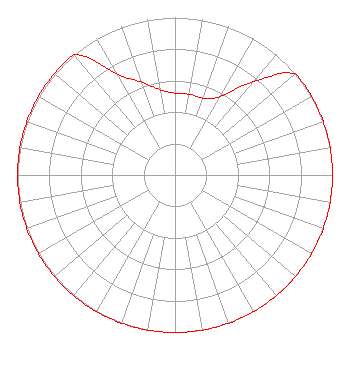 | ||||||||||||||||||
| Azimuth | Ratio | Azimuth | Ratio | Azimuth | Ratio | Azimuth | Ratio | ||||||||||||
| 0 | 0.520 | 10 | 0.520 | 20 | 0.520 | 30 | 0.577 | ||||||||||||
| 40 | 0.772 | 50 | 1.000 | 60 | 1.000 | 70 | 1.000 | ||||||||||||
| 80 | 1.000 | 90 | 1.000 | 100 | 1.000 | 110 | 1.000 | ||||||||||||
| 120 | 1.000 | 130 | 1.000 | 140 | 1.000 | 150 | 1.000 | ||||||||||||
| 160 | 1.000 | 170 | 1.000 | 180 | 1.000 | 190 | 1.000 | ||||||||||||
| 200 | 1.000 | 210 | 1.000 | 220 | 1.000 | 230 | 1.000 | ||||||||||||
| 240 | 1.000 | 250 | 1.000 | 260 | 1.000 | 270 | 1.000 | ||||||||||||
| 280 | 1.000 | 290 | 1.000 | 300 | 1.000 | 310 | 1.000 | ||||||||||||
| 320 | 1.000 | 330 | 0.743 | 340 | 0.629 | 350 | 0.551 | ||||||||||||
Structure Registration Number 1279711 Structure Type: GTOWER Registered To: M&M Broadcasters, LTD Structure Address: Donaldson Ln .23 Mi. From Fm434 Waco, TX County Name: McLennan County ASR Issued: 10/29/2018 Date Built: 11/01/2018 Site Elevation: 118.2 m (388 ft.) Structure Height: 129 m (423 ft.) Height Overall: 129 m (423 ft.) Overall Height AMSL: 247.2 m (811 ft.) FAA Determination: 10/24/2018 FAA Study #: 2018-ASW-14694-OE FAA Circular #: 70/7460-1K Paint & Light FAA Chapters: 3, 4, 5, 12 OM&L to remain the same as prior studies = PAINT/RED LIGHTS 31-32-15.3 N 97-05-32.9 W (NAD 83) 31-32-14.7 N 97-05-31.9 W (Converted to NAD 27) |
3951 Sarita Park Fort Worth, TX 76109 Phone: 817-645-6643 Individual | Title: Owner Date: 03/04/2020 Application Certifier GARY L. MOSS 3951 Sarita Park Fort Worth, TX 76109 Applicant Charles W Staples Cs Broadcast Technical Services, Inc 4424 Glenwick Lane University Park, TX 75205 TECHNICAL CONSULTANT | |||||||||||||||||