
FCCInfo.com
A Service of Cavell, Mertz & Associates, Inc.
(855) FCC-INFO
|
|
W247DN from 04/28/2020 W247DN from 04/06/2004 |
|
|
||||||||||||||||
|
|
W247DN Channel: 247D 97.3 MHz Richmond, Indiana Service: FX - A translator or application for a translator. Facility ID: 140566 Fac. Service: FX Programming Delivery Method: Unspecified Status: License Application Accepted: 04/27/2020 Application Granted: 04/28/2020 File Number: -0000112783 License Expires: 08/01/2020 Application Type: License To Cover FCC Website Links: LMS Facility Details This Application Other W247DN Applications Other W247DN Applications in CDBS Including Superseded Applications Mailing Address Correspondence for W247DN Correspondence related to application -0000112783 Service Contour - Open Street Map or USGS Map (60 dBu) Service Contour - KML / Google Earth (60 dBu) Facility Type: NON-COMMERCIAL EDUC. FM Class: D, A Noncommercial educational operating with no more than 10W Site Location: 39-49-41.0 N 84-55-57.0 W (NAD 83) Site Location: 39-49-40.8 N 84-55-57.1 W (Converted to NAD 27) Effective Radiated Power: 0.055 kW Transmitter Output Power: 0.073 kW Antenna Center HAAT: 0 m Antenna Center AMSL: 393.4 m (1291 ft.) Antenna Center HAG: 91.4 m (300 ft.) Site Elevation: 302 m. (991 ft.) Height Overall*: 110.6 m (363 ft.) (* As Filed In This Application, may differ from ASR Data, Below.) Directional Antenna Antenna Make/Model: Nicom BKG1/P-1DA(SLANT45) Antenna ID: 70698 Polarization: H
| ||||||||||||||||||
| Antenna Data for Antenna Id: 70698 W247DN FX File: -0000112783 Nicom - BKG1/P-1DA(SLANT45) Service: FX | 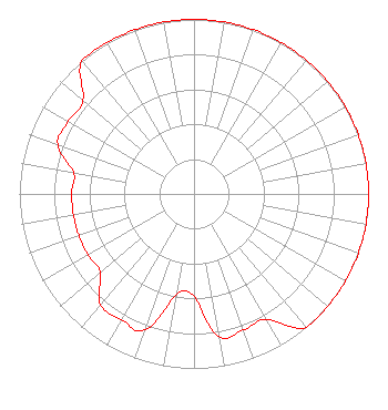 | ||||||||||||||||||
| Azimuth | Ratio | Azimuth | Ratio | Azimuth | Ratio | Azimuth | Ratio | ||||||||||||
| 0 | 1.000 | 10 | 1.000 | 20 | 1.000 | 30 | 1.000 | ||||||||||||
| 40 | 1.000 | 50 | 1.000 | 60 | 1.000 | 70 | 1.000 | ||||||||||||
| 80 | 1.000 | 90 | 1.000 | 100 | 1.000 | 110 | 1.000 | ||||||||||||
| 120 | 1.000 | 130 | 1.000 | 140 | 1.000 | 150 | 0.831 | ||||||||||||
| 160 | 0.831 | 170 | 0.831 | 180 | 0.588 | 190 | 0.588 | ||||||||||||
| 200 | 0.831 | 210 | 0.831 | 220 | 0.831 | 230 | 0.701 | ||||||||||||
| 240 | 0.701 | 250 | 0.701 | 260 | 0.701 | 270 | 0.701 | ||||||||||||
| 280 | 0.701 | 290 | 0.831 | 300 | 0.831 | 310 | 0.831 | ||||||||||||
| 320 | 1.000 | 330 | 1.000 | 340 | 1.000 | 350 | 1.000 | ||||||||||||
Structure Registration Number 1031399 Structure Type: TOWER Registered To: Rodgers Broadcasting Structure Address: 2301 W Main St Richmond, IN County Name: Wayne County ASR Issued: 01/11/2006 Date Built: 01/01/1997 Site Elevation: 302 m (991 ft.) Structure Height: 110.6 m (363 ft.) Height Overall: 110.6 m (363 ft.) Overall Height AMSL: 412.6 m (1354 ft.) FAA Determination: 03/03/1997 FAA Study #: 96-AGL-3278-OE FAA Circular #: 70/7460-1J Paint & Light FAA Chapters: 3, 4, 5, 13 Removed expiration date from determination. Scenario 1./jjs/case#635066 39-49-41.0 N 84-55-57.0 W (NAD 83) 39-49-40.8 N 84-55-57.1 W (Converted to NAD 27) |
8 Martin Luther Drive Fort Wayne, IN 46825 Phone: 260-483-8236 Not-for-Profit | Title: President And Ceo Date: 04/27/2020 Application Certifier STAR EDUCATIONAL MEDIA NETWORK, INC. Star Educational Media Network, Inc. 8 Martin Luther Drive Fort Wayne, IN 46825 Applicant Justin Asher Asher Broadcast Consulting, Llc 579 Babcock Road Bronson, MI 49028 Technical Consultant Cary S. Tepper Tepper Law Firm, Llc 4900 Auburn Avenue Suite 100 Bethesda, MD 20814 Communications Counsel | |||||||||||||||||