
FCCInfo.com
A Service of Cavell, Mertz & Associates, Inc.
(855) FCC-INFO
|
|
|
|
|
||||||||||||||||
|
|
K227CO Channel: 227D 93.3 MHz Logan, Utah Service: FX - A translator or application for a translator. Facility ID: 143532 Fac. Service: FX Programming Delivery Method: Unspecified Status: License Application Accepted: 08/05/2020 Application Granted: 08/14/2020 File Number: -0000120173 License Expires: 10/01/2021 Application Type: License To Cover FCC Website Links: LMS Facility Details This Application Other K227CO Applications Other K227CO Applications in CDBS Including Superseded Applications Mailing Address Correspondence for K227CO Correspondence related to application -0000120173 Service Contour - Open Street Map or USGS Map (60 dBu) Service Contour - KML / Google Earth (60 dBu) Facility Type: FM STATION Class: D, A Noncommercial educational operating with no more than 10W Site Location: 41-48-43.5 N 111-47-32.8 W (NAD 83) Site Location: 41-48-43.8 N 111-47-30.0 W (Converted to NAD 27) Effective Radiated Power: 0 kW Horiz. ; 0.099 kW Vert. Antenna Center HAAT: 0 m Antenna Center AMSL: 0 m Horiz.; 1659.8 m Vert. Antenna Center HAG: 0 m Horiz.; 10 m Vert. Site Elevation: 1649.8 m. (5413 ft.) Height Overall*: 32.3 m (106 ft.) (* As Filed In This Application, may differ from ASR Data, Below.) Directional Antenna Antenna Make/Model: NIC BKG1 Antenna ID: 1007162 Polarization: H
| ||||||||||||||||||
| Antenna Data for Antenna Id: 1007162 K227CO FX File: -0000120173 NIC - BKG1 Service: FX | 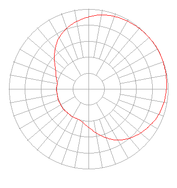 | ||||||||||||||||||
| Azimuth | Ratio | Azimuth | Ratio | Azimuth | Ratio | Azimuth | Ratio | ||||||||||||
| 0 | 0.899 | 10 | 0.939 | 20 | 0.963 | 30 | 0.978 | ||||||||||||
| 40 | 0.989 | 50 | 0.995 | 60 | 1.000 | 70 | 0.995 | ||||||||||||
| 80 | 0.989 | 90 | 0.978 | 100 | 0.963 | 110 | 0.939 | ||||||||||||
| 120 | 0.899 | 130 | 0.856 | 140 | 0.804 | 150 | 0.737 | ||||||||||||
| 160 | 0.650 | 170 | 0.557 | 180 | 0.479 | 190 | 0.423 | ||||||||||||
| 200 | 0.399 | 210 | 0.403 | 220 | 0.398 | 230 | 0.404 | ||||||||||||
| 240 | 0.401 | 250 | 0.404 | 260 | 0.398 | 270 | 0.403 | ||||||||||||
| 280 | 0.399 | 290 | 0.432 | 300 | 0.479 | 310 | 0.557 | ||||||||||||
| 320 | 0.650 | 330 | 0.737 | 340 | 0.804 | 350 | 0.856 | ||||||||||||
Structure Registration Number 1279398 Structure Type: TOWER Registered To: Cellco Partnership Structure Address: Nw 1/4, Sec 1, T12n, R1e - Off Of Cr 4400 N Hyde Park, UT County Name: Cache County ASR Issued: 02/07/2020 Date Built: 10/28/2011 Site Elevation: 1649.8 m (5413 ft.) Structure Height: 30.5 m (100 ft.) Height Overall: 32.3 m (106 ft.) Overall Height AMSL: 1682.1 m (5519 ft.) FAA Determination: 05/19/2011 FAA Study #: 2011-ANM-722-OE Paint & Light FAA Chapters: NONE 41-48-43.5 N 111-47-32.8 W (NAD 83) 41-48-43.8 N 111-47-30.0 W (Converted to NAD 27) |
810 West 200 North Logan, UT 84323 Phone: 435-752-1390 Limited Liability Company | Title: Manager Date: 08/05/2020 Application Certifier FRANDSEN MEDIA GROUP, LLC Frandsen Media Group, Llc 810 West 200 North Logan, UT 84323 Applicant Gene Wisniewski Genew2012 1472 E 3100 S Wendell, ID 83355 CONSULTING ENGINEER DAVID D Oxenford Wilkinson Barker Knauer, Llp 1800 M Street, N.w. Suite 800n Washington, DC 20036 | |||||||||||||||||