
FCCInfo.com
A Service of Cavell, Mertz & Associates, Inc.
(855) FCC-INFO
|
|
|
|
|
||||||||||||||||
|
|
W271CG Channel: 271D 102.1 MHz Quincy, Massachusetts Service: FX - A translator or application for a translator. Facility ID: 156579 Fac. Service: FX Programming Delivery Method: Unspecified Status: Construction Permit Application Accepted: 08/14/2020 Application Granted: 09/01/2020 File Number: -0000120411 W271CG CP Expires: 08/31/2023 Application Type: Minor Modification FCC Website Links: LMS Facility Details This Application Other W271CG Applications Other W271CG Applications in CDBS Including Superseded Applications Mailing Address Correspondence for W271CG Correspondence related to application -0000120411 Service Contour - Open Street Map or USGS Map (60 dBu) Service Contour - KML / Google Earth (60 dBu) Facility Type: NON-COMMERCIAL EDUC. FM Class: D, A Noncommercial educational operating with no more than 10W Site Location: 42-18-37.0 N 71-14-12.0 W (NAD 83) Site Location: 42-18-36.6 N 71-14-13.8 W (Converted to NAD 27) Effective Radiated Power: 0.01 kW Antenna Center HAAT: 0 m Antenna Center AMSL: 406.6 m (1334 ft.) Antenna Center HAG: 360 m (1181 ft.) Site Elevation: 46.6 m. (153 ft.) Height Overall*: 395.1 m (1296 ft.) (* As Filed In This Application, may differ from ASR Data, Below.) Directional Antenna Antenna Make/Model: Electronics Research Inc. 100A-1 custom Antenna ID: 118413 Polarization: H
| ||||||||||||||||||
| Antenna Data for Antenna Id: 118413 W271CG FX File: -0000120411 Electronics Research Inc. - 100A-1 custom Service: FX | 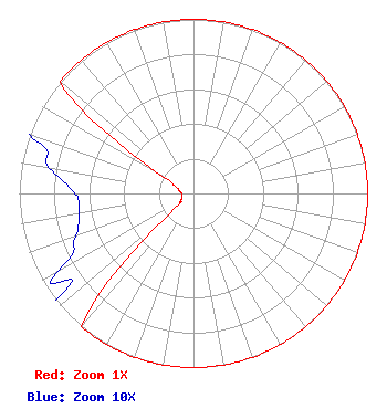 | ||||||||||||||||||
| Azimuth | Ratio | Azimuth | Ratio | Azimuth | Ratio | Azimuth | Ratio | ||||||||||||
| 0 | 1.000 | 10 | 1.000 | 20 | 1.000 | 30 | 1.000 | ||||||||||||
| 40 | 1.000 | 50 | 1.000 | 60 | 1.000 | 70 | 1.000 | ||||||||||||
| 80 | 1.000 | 90 | 1.000 | 100 | 1.000 | 110 | 1.000 | ||||||||||||
| 120 | 1.000 | 130 | 1.000 | 140 | 1.000 | 150 | 1.000 | ||||||||||||
| 160 | 1.000 | 170 | 1.000 | 180 | 1.000 | 190 | 1.000 | ||||||||||||
| 200 | 1.000 | 210 | 1.000 | 220 | 1.000 | 230 | 0.182 | ||||||||||||
| 240 | 0.090 | 250 | 0.072 | 260 | 0.067 | 270 | 0.068 | ||||||||||||
| 280 | 0.084 | 290 | 0.105 | 300 | 0.250 | 310 | 1.000 | ||||||||||||
| 320 | 1.000 | 330 | 1.000 | 340 | 1.000 | 350 | 1.000 | ||||||||||||
Structure Registration Number 1003433 Structure Type: GTOWER Registered To: American Towers LLC Structure Address: 350 Cedar Street (282685) Needham Heights, MA County Name: Norfolk County ASR Issued: 04/07/2023 Date Built: 01/01/1957 Site Elevation: 46.6 m (153 ft.) Structure Height: 363.4 m (1192 ft.) Height Overall: 395.1 m (1296 ft.) Overall Height AMSL: 441.7 m (1449 ft.) FAA Determination: 02/08/2023 FAA Study #: 2022-ANE-1323-OE FAA Circular #: 70/7460-1L Paint & Light FAA Chapters: 3, 4, 5, 12 OM&L to remain the same as prior study = PAINT/RED LIGHTS 42-18-37.2 N 71-14-11.7 W (NAD 83) 42-18-36.8 N 71-14-13.5 W (Converted to NAD 27) |
356 Broad Street Fitchburg, MA 01420 Phone: 978-655-9111 Not-for-Profit | Title: President Date: 08/14/2020 Application Certifier HORIZON CHRISTIAN FELLOWSHIP Horizon Christian Fellowship 356 Broad Street Fitchburg, MA 01420 Applicant ROBERT McCormick Rcm Enterprises 1908 Sweetbriar Dr Goshen, IN 46528 CONSULTING ENGINEER Matthew H. McCormick Fletcher, Heald & Hildreth, Plc 1300 North 17th Street 11th Floor Arlington, VA 22209 | |||||||||||||||||