
FCCInfo.com
A Service of Cavell, Mertz & Associates, Inc.
(855) FCC-INFO
|
|
|
|
|
||||||||||||||||
|
|
W237BE Channel: 237D 95.3 MHz Pensacola, Florida Service: FX - A translator or application for a translator. Facility ID: 146196 Fac. Service: FX Programming Delivery Method: Unspecified Status: License Application Accepted: 08/31/2020 Application Granted: 09/28/2020 File Number: -0000120925 License Expires: 10/06/2021 Application Type: License To Cover FCC Website Links: LMS Facility Details This Application Other W237BE Applications Other W237BE Applications in CDBS Including Superseded Applications Mailing Address Correspondence for W237BE Correspondence related to application -0000120925 Service Contour - Open Street Map or USGS Map (60 dBu) Service Contour - KML / Google Earth (60 dBu) Facility Type: FM STATION Class: D, A Noncommercial educational operating with no more than 10W Site Location: 30-37-30.7 N 87-26-38.9 W (NAD 83) Site Location: 30-37-30.0 N 87-26-39.0 W (Converted to NAD 27) Effective Radiated Power: 0.25 kW Transmitter Output Power: 0.006 kW Antenna Center HAAT: 81.8 m Horiz.; 0 m Vert. Antenna Center AMSL: 305 m (1001 ft.) Antenna Center HAG: 259 m (850 ft.) Site Elevation: 46 m. (151 ft.) Height Overall*: 288 m (945 ft.) (* As Filed In This Application, may differ from ASR Data, Below.) Directional Antenna Antenna Make/Model: BEXT Log-R Composite Antenna ID: 78347 Polarization: H
| ||||||||||||||||||
| Antenna Data for Antenna Id: 78347 W237BE FX File: -0000120925 BEXT - Log-R Composite Service: FX | 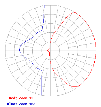 | ||||||||||||||||||
| Azimuth | Ratio | Azimuth | Ratio | Azimuth | Ratio | Azimuth | Ratio | ||||||||||||
| 0 | 0.187 | 10 | 0.365 | 20 | 0.552 | 30 | 0.950 | ||||||||||||
| 40 | 1.000 | 50 | 1.000 | 60 | 1.000 | 70 | 1.000 | ||||||||||||
| 80 | 1.000 | 90 | 1.000 | 100 | 1.000 | 110 | 1.000 | ||||||||||||
| 120 | 1.000 | 130 | 1.000 | 140 | 1.000 | 150 | 0.900 | ||||||||||||
| 160 | 0.637 | 170 | 0.470 | 180 | 0.263 | 190 | 0.111 | ||||||||||||
| 200 | 0.055 | 210 | 0.048 | 220 | 0.049 | 230 | 0.049 | ||||||||||||
| 240 | 0.049 | 250 | 0.054 | 260 | 0.062 | 270 | 0.068 | ||||||||||||
| 280 | 0.066 | 290 | 0.058 | 300 | 0.051 | 310 | 0.049 | ||||||||||||
| 320 | 0.049 | 330 | 0.049 | 340 | 0.052 | 350 | 0.084 | ||||||||||||
Structure Registration Number 1235802 Structure Type: TOWER Registered To: ADX Communicatons of Escambia, LLC Structure Address: 4100' West Of Alabama Highway 112, On The N 30-37-30 Latitude Line Robertsdale, AL County Name: Baldwin County ASR Issued: 06/08/2020 Date Built: 01/15/2003 Site Elevation: 46 m (151 ft.) Structure Height: 287 m (942 ft.) Height Overall: 288 m (945 ft.) Overall Height AMSL: 334 m (1096 ft.) FAA Determination: 07/29/2002 FAA Study #: 02-ASO-2641-OE FAA Circular #: 70/7460-1K Paint & Light FAA Chapters: 3, 4, 5, 12 Removed final date from determination. Scenario 3./jjs/case#635066 30-37-30.7 N 87-26-38.9 W (NAD 83) 30-37-30.0 N 87-26-39.0 W (Converted to NAD 27) |
7521 Plantation Rd. Pensacola, FL 32501 Phone: 850-262-6000 Trust | Title: Trustee Date: 08/31/2020 Application Certifier THE DAVID EARL HOXENG REVOCABLE TRUST The David Earl Hoxeng Revocable Trust 7521 Plantation Rd. Pensacola, FL 32501 Applicant Dan J Alpert The Law Office Of Dan J. Alpert 2120 21st Rd. N Arlington, VA 22201 Charles M Anderson Anderson Associates 1519 Euclid Avenue Bowling Green, KY 42103 BROADCAST ENGINEERING CONSULTANT | |||||||||||||||||