
FCCInfo.com
A Service of Cavell, Mertz & Associates, Inc.
(855) FCC-INFO
|
|
W259DI from 09/26/2018 |
|
|
||||||||||||||||
|
|
W259DI Channel: 259D 99.7 MHz Youngstown, Ohio Service: FX - A translator or application for a translator. Facility ID: 201366 Fac. Service: FX Programming Delivery Method: Unspecified Status: License Application Accepted: 09/17/2020 Application Granted: 10/06/2020 File Number: -0000121790 License Expires: 10/01/2028 Application Type: License To Cover FCC Website Links: LMS Facility Details This Application Other W259DI Applications Other W259DI Applications in CDBS Including Superseded Applications Mailing Address Correspondence for W259DI Correspondence related to application -0000121790 Service Contour - Open Street Map or USGS Map (60 dBu) Service Contour - KML / Google Earth (60 dBu) Facility Type: FM STATION Class: D, A Noncommercial educational operating with no more than 10W Site Location: 41-03-23.4 N 80-38-43.0 W (NAD 83) Site Location: 41-03-23.2 N 80-38-43.7 W (Converted to NAD 27) Effective Radiated Power: 0.2 kW Antenna Center HAAT: 0 m Antenna Center AMSL: 560 m (1837 ft.) Antenna Center HAG: 223 m (732 ft.) Site Elevation: 337 m. (1106 ft.) Height Overall*: 436 m (1430 ft.) (* As Filed In This Application, may differ from ASR Data, Below.) Directional Antenna Antenna Make/Model: Scala CL-FM/VRM/50N Antenna ID: 135382 Polarization: H
| ||||||||||||||||||
| Antenna Data for Antenna Id: 135382 W259DI FX File: -0000121790 Scala - CL-FM/VRM/50N Service: FX Pattern and Field Values Include a 355° Clockwise Rotation | 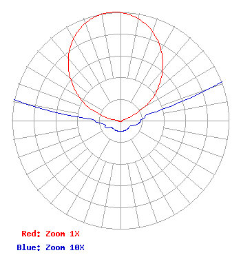 | ||||||||||||||||||
| Azimuth | Ratio | Azimuth | Ratio | Azimuth | Ratio | Azimuth | Ratio | ||||||||||||
| 5 | 0.980 | 15 | 0.915 | 25 | 0.813 | 35 | 0.678 | ||||||||||||
| 45 | 0.522 | 55 | 0.360 | 65 | 0.165 | 75 | 0.040 | ||||||||||||
| 85 | 0.021 | 95 | 0.018 | 105 | 0.015 | 115 | 0.011 | ||||||||||||
| 125 | 0.010 | 135 | 0.010 | 145 | 0.010 | 155 | 0.010 | ||||||||||||
| 165 | 0.010 | 175 | 0.010 | 185 | 0.010 | 195 | 0.010 | ||||||||||||
| 205 | 0.010 | 215 | 0.010 | 225 | 0.010 | 235 | 0.011 | ||||||||||||
| 245 | 0.015 | 255 | 0.015 | 265 | 0.021 | 275 | 0.040 | ||||||||||||
| 285 | 0.165 | 295 | 0.360 | 305 | 0.522 | 315 | 0.678 | ||||||||||||
| 325 | 0.813 | 335 | 0.915 | 345 | 0.980 | 355 | 1.000 | ||||||||||||
Structure Registration Number 1013678 Structure Type: GTOWER Registered To: American Towers, LLC Structure Address: 3930 Sunset Blvd (youngstown S. 1433 #307645) Youngstown, OH County Name: Mahoning County ASR Issued: 02/07/2020 Date Built: 11/15/1976 Site Elevation: 336.8 m (1105 ft.) Structure Height: 417.9 m (1371 ft.) Height Overall: 435.9 m (1430 ft.) Overall Height AMSL: 772.7 m (2535 ft.) FAA Determination: 01/24/2007 FAA Study #: 2006-AGL-10122-OE FAA Circular #: 70/7460-1J Paint & Light FAA Chapters: 4, 7, 13 OM&L to remain the same as prior study = 24-HR HI-STROBES 41-03-23.4 N 80-38-43.0 W (NAD 83) 41-03-23.2 N 80-38-43.7 W (Converted to NAD 27) |
P.o. Box 221343 Beachwood, OH 44122 Phone: 216-773-6600 Limited Liability Company | Title: Manager Date: 09/17/2020 Application Certifier KINGSTRUST LLC Kingstrust Llc P.o. Box 221343 Beachwood, OH 44122 Applicant Dale Edwards Kings Trust P.o. Box 221343 Beachwood, OH 44122 Bert Goldman Goldman Engineering Management, Inc 560 Perkins Way Auburn, CA 95603 TECHNICAL CONSULTANT | |||||||||||||||||