
FCCInfo.com
A Service of Cavell, Mertz & Associates, Inc.
(855) FCC-INFO
|
|
|
|
|
||||||||||||||||
|
|
W237EQ Channel: 237D 95.3 MHz Sandusky, Michigan Service: FX - A translator or application for a translator. Facility ID: 201669 Fac. Service: FX Programming Delivery Method: Unspecified Status: License Application Accepted: 12/17/2020 Application Granted: 01/15/2021 File Number: -0000129807 License Expires: 10/01/2028 Application Type: License To Cover FCC Website Links: LMS Facility Details This Application Other W237EQ Applications Other W237EQ Applications in CDBS Including Superseded Applications Mailing Address Correspondence for W237EQ Correspondence related to application -0000129807 Service Contour - Open Street Map or USGS Map (60 dBu) Service Contour - KML / Google Earth (60 dBu) Facility Type: FM STATION Class: D, A Noncommercial educational operating with no more than 10W Site Location: 43-23-36.1 N 82-50-05.8 W (NAD 83) Site Location: 43-23-36.0 N 82-50-06.0 W (Converted to NAD 27) Effective Radiated Power: 0.25 kW Antenna Center HAAT: 0 m Antenna Center AMSL: 335 m (1099 ft.) Antenna Center HAG: 100 m (328 ft.) Site Elevation: 235 m. (771 ft.) Height Overall*: 103 m (338 ft.) (* As Filed In This Application, may differ from ASR Data, Below.) Directional Antenna Antenna Make/Model: Nicom BKG77 Antenna ID: 130055 Polarization: H
| ||||||||||||||||||
| Antenna Data for Antenna Id: 130055 W237EQ FX File: -0000129807 Nicom - BKG77 Service: FX Pattern and Field Values Include a 340° Clockwise Rotation | 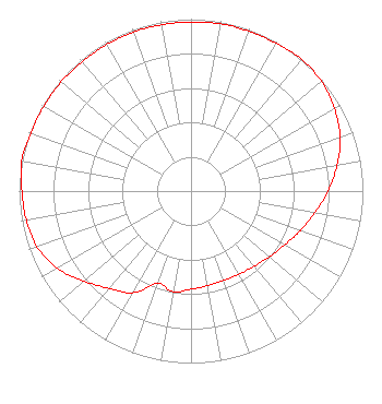 | ||||||||||||||||||
| Azimuth | Ratio | Azimuth | Ratio | Azimuth | Ratio | Azimuth | Ratio | ||||||||||||
| 0 | 0.983 | 10 | 0.988 | 20 | 0.988 | 30 | 0.992 | ||||||||||||
| 40 | 1.000 | 50 | 0.991 | 60 | 0.963 | 70 | 0.923 | ||||||||||||
| 80 | 0.862 | 90 | 0.797 | 100 | 0.731 | 110 | 0.676 | ||||||||||||
| 120 | 0.628 | 130 | 0.594 | 140 | 0.571 | 150 | 0.558 | ||||||||||||
| 160 | 0.553 | 170 | 0.558 | 180 | 0.571 | 190 | 0.594 | ||||||||||||
| 200 | 0.571 | 210 | 0.682 | 220 | 0.738 | 230 | 0.815 | ||||||||||||
| 240 | 0.897 | 250 | 0.953 | 260 | 0.973 | 270 | 0.983 | ||||||||||||
| 280 | 1.000 | 290 | 0.992 | 300 | 0.988 | 310 | 0.988 | ||||||||||||
| 320 | 0.983 | 330 | 0.983 | 340 | 0.983 | 350 | 0.983 | ||||||||||||
Structure Registration Number 1007619 Structure Type: 2GTA1 Registered To: SANILAC BROADCASTING COMPANY Structure Address: Tower 1 (n) Cooper Rd 1.45 Mi S Sandusky, MI County Name: Sanilac County ASR Issued: 12/17/2012 Date Built: 12/01/1987 Site Elevation: 235 m (771 ft.) Structure Height: 101.8 m (334 ft.) Height Overall: 102.8 m (337 ft.) Overall Height AMSL: 337.8 m (1108 ft.) FAA Determination: 11/21/2012 FAA Study #: 2012-AGL-9371-OE Paint & Light FAA Chapters: 1, 3, 11, 21 PRIOR STUDY 1982-AGL-1320-OE 43-23-36.2 N 82-50-05.8 W (NAD 83) 43-23-36.1 N 82-50-06.0 W (Converted to NAD 27) |
19 South Elk Street Sandusky, MI 48471 Phone: 810-648-2700 Corporation | Title: General Manager Date: 12/17/2020 Application Certifier SANILAC BROADCASTING COMPANY Sanilac Broadcasting Company 19 South Elk Street Sandusky, MI 48471 Applicant BRUCE Bellamy Munn-reese Po Box 220 Coldwater, MI 49036 CONSULTING ENGINEER | |||||||||||||||||