
FCCInfo.com
A Service of Cavell, Mertz & Associates, Inc.
(855) FCC-INFO
|
|
W290CA from 08/27/2004 |
|
|
||||||||||||||||
|
|
W290CA Channel: 290D 105.9 MHz Cleveland, Tennessee Service: FX - A translator or application for a translator. Facility ID: 140986 Fac. Service: FX Programming Delivery Method: Unspecified Status: License Application Accepted: 01/19/2021 Application Granted: 01/29/2021 File Number: -0000131694 License Expires: 08/01/2028 Application Type: License To Cover FCC Website Links: LMS Facility Details This Application Other W290CA Applications Other W290CA Applications in CDBS Including Superseded Applications Mailing Address Correspondence for W290CA Correspondence related to application -0000131694 Service Contour - Open Street Map or USGS Map (60 dBu) Service Contour - KML / Google Earth (60 dBu) Facility Type: NON-COMMERCIAL EDUC. FM Class: D, A Noncommercial educational operating with no more than 10W Site Location: 35-09-37.1 N 84-51-59.4 W (NAD 83) Site Location: 35-09-36.8 N 84-51-59.6 W (Converted to NAD 27) Effective Radiated Power: 0.025 kW Transmitter Output Power: 0.117 kW Antenna Center HAAT: 63.5 m Horiz.; 0 m Vert. Antenna Center AMSL: 323.7 m (1062 ft.) Antenna Center HAG: 53 m (174 ft.) Site Elevation: 270.7 m. (888 ft.) Height Overall*: 57.6 m (189 ft.) (* As Filed In This Application, may differ from ASR Data, Below.) Directional Antenna Antenna Make/Model: NICOM BKG77 Antenna ID: 102769 Polarization: H
| ||||||||||||||||||
| Antenna Data for Antenna Id: 102769 W290CA FX File: -0000131694 NICOM - BKG77 Service: FX | 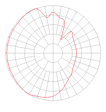 | ||||||||||||||||||
| Azimuth | Ratio | Azimuth | Ratio | Azimuth | Ratio | Azimuth | Ratio | ||||||||||||
| 0 | 0.852 | 10 | 0.762 | 20 | 0.692 | 30 | 0.327 | ||||||||||||
| 40 | 0.581 | 50 | 0.536 | 60 | 0.504 | 70 | 0.493 | ||||||||||||
| 80 | 0.493 | 90 | 0.493 | 100 | 0.493 | 110 | 0.493 | ||||||||||||
| 120 | 0.507 | 130 | 0.536 | 140 | 0.596 | 150 | 0.643 | ||||||||||||
| 160 | 0.729 | 170 | 0.826 | 180 | 0.908 | 190 | 0.947 | ||||||||||||
| 200 | 0.966 | 210 | 1.000 | 220 | 0.992 | 230 | 0.980 | ||||||||||||
| 240 | 0.966 | 250 | 0.966 | 260 | 0.966 | 270 | 0.966 | ||||||||||||
| 280 | 0.966 | 290 | 0.966 | 300 | 0.966 | 310 | 0.966 | ||||||||||||
| 320 | 0.984 | 330 | 1.000 | 340 | 0.982 | 350 | 0.758 | ||||||||||||
Structure Registration Number 1248834 Structure Type: MTOWER Registered To: Crown Castle Towers 06-2 LLC Structure Address: 760 Railroad Street Cleveland, TN County Name: Bradley County ASR Issued: 05/05/2016 Date Built: 06/10/2005 Site Elevation: 270.7 m (888 ft.) Structure Height: 54.6 m (179 ft.) Height Overall: 57.6 m (189 ft.) Overall Height AMSL: 328.3 m (1077 ft.) FAA Determination: 01/30/2013 FAA Study #: 2012-ASO-11602-OE Paint & Light FAA Chapters: NONE PRIOR STUDY 2004-ASO-6173-OE 35-09-37.1 N 84-51-59.4 W (NAD 83) 35-09-36.8 N 84-51-59.6 W (Converted to NAD 27) |
160 Gooding Street West Suite B Twin Falls, ID 83301 Phone: 208-733-3551 Not-for-Profit | Title: President Date: 01/19/2021 Application Certifier RADIO BY GRACE, INC. Radio By Grace, Inc. 160 Gooding Street West Suite B Twin Falls, ID 83301 Applicant Jim Turvaville Turbo Tech Services 360 Patton Street - Po Box 144 Mobeetie, TX 79061 | |||||||||||||||||