
FCCInfo.com
A Service of Cavell, Mertz & Associates, Inc.
(855) FCC-INFO
|
|
|
|
|
||||||||||||||||
|
|
W292FS Channel: 292D 106.3 MHz Louisville, Kentucky Service: FX - A translator or application for a translator. Facility ID: 202013 Fac. Service: FX Programming Delivery Method: Unspecified Status: License Application Accepted: 01/25/2021 Application Granted: 02/16/2021 File Number: -0000132311 License Expires: 08/01/2020 Application Type: License To Cover FCC Website Links: LMS Facility Details This Application Other W292FS Applications Other W292FS Applications in CDBS Including Superseded Applications Mailing Address Correspondence for W292FS Correspondence related to application -0000132311 Service Contour - Open Street Map or USGS Map (60 dBu) Service Contour - KML / Google Earth (60 dBu) Facility Type: FM STATION Class: D, A Noncommercial educational operating with no more than 10W Site Location: 38-12-46.0 N 85-33-13.0 W (NAD 83) Site Location: 38-12-45.7 N 85-33-13.1 W (Converted to NAD 27) Effective Radiated Power: 0.25 kW Transmitter Output Power: 0.324 kW Antenna Center HAAT: 0 m Antenna Center AMSL: 314.3 m (1031 ft.) Antenna Center HAG: 107 m (351 ft.) Site Elevation: 207.3 m. (680 ft.) Height Overall*: 130.8 m (429 ft.) (* As Filed In This Application, may differ from ASR Data, Below.) Directional Antenna Antenna Make/Model: Propagation System Inc FML Antenna ID: 134474 Polarization: H
| ||||||||||||||||||
| Antenna Data for Antenna Id: 134474 W292FS FX File: -0000132311 Propagation System Inc - FML Service: FX | 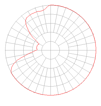 | ||||||||||||||||||
| Azimuth | Ratio | Azimuth | Ratio | Azimuth | Ratio | Azimuth | Ratio | ||||||||||||
| 0 | 1.000 | 10 | 1.000 | 20 | 1.000 | 30 | 1.000 | ||||||||||||
| 40 | 1.000 | 50 | 1.000 | 60 | 1.000 | 70 | 1.000 | ||||||||||||
| 80 | 1.000 | 90 | 1.000 | 100 | 1.000 | 110 | 1.000 | ||||||||||||
| 120 | 1.000 | 130 | 1.000 | 140 | 1.000 | 150 | 1.000 | ||||||||||||
| 160 | 1.000 | 170 | 1.000 | 180 | 1.000 | 190 | 1.000 | ||||||||||||
| 200 | 1.000 | 210 | 1.000 | 220 | 1.000 | 230 | 1.000 | ||||||||||||
| 240 | 1.000 | 250 | 0.850 | 260 | 0.500 | 270 | 0.310 | ||||||||||||
| 280 | 0.310 | 290 | 0.310 | 300 | 0.310 | 310 | 0.600 | ||||||||||||
| 320 | 0.850 | 330 | 0.900 | 340 | 0.900 | 350 | 0.900 | ||||||||||||
Structure Registration Number 1061956 Structure Type: TOWER Registered To: P & B TOWERS LLC Structure Address: 2400 Arcee Way Jeffersontown, KY County Name: Jefferson County ASR Issued: 03/18/1999 Date Built: 02/16/1999 Site Elevation: 207.3 m (680 ft.) Structure Height: 130.8 m (429 ft.) Height Overall: 130.8 m (429 ft.) Overall Height AMSL: 338.1 m (1109 ft.) FAA Determination: 02/11/1999 FAA Study #: 99-ASO-0380-OE FAA Circular #: 70/7460-1J Paint & Light FAA Chapters: 4, 8, 13 Removed expiration date from determination. Scenario 1./jjs/case#635066 38-12-46.0 N 85-33-13.0 W (NAD 83) 38-12-45.7 N 85-33-13.1 W (Converted to NAD 27) |
P.o. Box 2087 Elizabethtown, KY 42702 Phone: 270-766-1035 Corporation | Title: President Date: 01/25/2021 Application Certifier W & B BROADCASTING CO., INC. W & B Broadcasting Co., Inc. P.o. Box 2087 Elizabethtown, KY 42702 Applicant CHARLES M Anderson Charles M. Anderson Associates 1519 Euclid Avenue Bowling Green, KY 42103 BROADCAST CONSULTANT JOHN Neely, Esq Miller And Neely, Pc 4 Simms Court Kensington, MD 20895 | |||||||||||||||||