
FCCInfo.com
A Service of Cavell, Mertz & Associates, Inc.
(855) FCC-INFO
|
|
|
|
|
||||||||||||||||
|
|
W248CW Channel: 248D 97.5 MHz High Point, North Carolina Service: FX - A translator or application for a translator. Facility ID: 201652 Fac. Service: FX Programming Delivery Method: Unspecified Status: Construction Permit Application Accepted: 06/25/2021 Application Granted: 07/19/2021 File Number: -0000151055 W248CW CP Expires: 07/18/2024 Application Type: Minor Modification FCC Website Links: LMS Facility Details This Application Other W248CW Applications Other W248CW Applications in CDBS Including Superseded Applications Mailing Address Correspondence for W248CW Correspondence related to application -0000151055 Service Contour - Open Street Map or USGS Map (60 dBu) Service Contour - KML / Google Earth (60 dBu) Facility Type: FM STATION Class: D, A Noncommercial educational operating with no more than 10W Site Location: 35-54-58.0 N 80-01-00.0 W (NAD 83) Site Location: 35-54-57.5 N 80-01-00.9 W (Converted to NAD 27) Effective Radiated Power: 0.175 kW Antenna Center HAAT: 0 m Antenna Center AMSL: 346.7 m (1137 ft.) Antenna Center HAG: 80 m (262 ft.) Site Elevation: 266.7 m. (875 ft.) Height Overall*: 85 m (279 ft.) (* As Filed In This Application, may differ from ASR Data, Below.) Directional Antenna Antenna Make/Model: Nicom BKG-77 Antenna ID: 0 Polarization: H
| ||||||||||||||||||
| Antenna Data for Antenna Id: 0 W248CW FX File: -0000151055 Nicom - BKG-77 Service: FX | 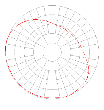 | ||||||||||||||||||
| Azimuth | Ratio | Azimuth | Ratio | Azimuth | Ratio | Azimuth | Ratio | ||||||||||||
| 0 | 0.620 | 10 | 0.580 | 20 | 0.570 | 30 | 0.560 | ||||||||||||
| 40 | 0.550 | 50 | 0.560 | 60 | 0.570 | 70 | 0.600 | ||||||||||||
| 80 | 0.630 | 90 | 0.670 | 100 | 0.730 | 110 | 0.820 | ||||||||||||
| 120 | 0.900 | 130 | 0.950 | 140 | 0.960 | 150 | 0.980 | ||||||||||||
| 160 | 1.000 | 170 | 0.980 | 180 | 0.980 | 190 | 0.980 | ||||||||||||
| 200 | 0.980 | 210 | 0.980 | 220 | 0.980 | 230 | 0.980 | ||||||||||||
| 240 | 0.980 | 250 | 0.980 | 260 | 0.990 | 270 | 0.990 | ||||||||||||
| 280 | 1.000 | 290 | 0.990 | 300 | 0.960 | 310 | 0.920 | ||||||||||||
| 320 | 0.860 | 330 | 0.800 | 340 | 0.730 | 350 | 0.670 | ||||||||||||
Structure Registration Number 1002084 Structure Type: TOWER Registered To: RITCHY BROADCASTING CO INC Structure Address: 6223 Old Mendenhall Highpoint, NC County Name: Randolph County ASR Issued: 09/30/1996 Date Built: 01/01/1984 Site Elevation: 266.7 m (875 ft.) Structure Height: 84.1 m (276 ft.) Height Overall: 85 m (279 ft.) Overall Height AMSL: 351.7 m (1154 ft.) FAA Determination: 11/23/1983 FAA Study #: 83-ASO-2339-OE FAA Circular #: 70/7460-1F Paint & Light FAA Chapters: 3, 4, 5, 9 35-54-58.0 N 80-01-00.0 W (NAD 83) 35-54-57.5 N 80-01-00.9 W (Converted to NAD 27) |
1841 Bethel Drive High Point, NC 27260 Phone: 336-884-5716 Corporation | Title: President Date: 06/25/2021 Application Certifier IGLESIA NUEVA VIDA OF HIGH POINT, INC. Iglesia Nueva Vida Of High Point, Inc. 1841 Bethel Drive High Point, NC 27260 Applicant Carl E Gluck Carl T Jones Corp 7901 Yarnwood Court Springfield, VA 22153 Technical Consultant FRANCISCO R. MONTERO Fletcher, Helad & Hildreth, Plc 1300 N 17th Street, 11th Floor Suite 1100 Arlington, VA 22209 | |||||||||||||||||