
FCCInfo.com
A Service of Cavell, Mertz & Associates, Inc.
(855) FCC-INFO
|
|
|
|  |
|
|||||||||||||||
|
|
WSEW Channel: 204B 88.7 MHz Sanford, Maine Service: FM - A full-service FM station or application. Facility ID: 73718 Fac. Service: FM Status: License Application Accepted: 04/14/2021 Application Granted: 04/22/2021 File Number: -0000136983 License Expires: 04/01/2022 Application Type: Amendment FCC Website Links: LMS Facility Details This Application Other WSEW Applications Other WSEW Applications in CDBS Including Superseded Applications Mailing Address Correspondence for WSEW Correspondence related to application -0000136983 Service Contour - Open Street Map or USGS Map (60 dBu) Service Contour - KML / Google Earth (60 dBu) Public Inspection Files Facility Type: NON-COMMERCIAL EDUC. FM Class: B, A Zone I or I-A station; with 25kW-50kW ERP and a class contour distance 39km-52km Site Location: 43-13-26.0 N 70-58-17.0 W (NAD 83) Site Location: 43-13-25.7 N 70-58-18.8 W (Converted to NAD 27) Effective Radiated Power: 17 kW Antenna Center HAAT: 130 m (427 ft.) Antenna Center AMSL: 203 m (666 ft.) Antenna Center HAG: 87 m (285 ft.) Calculated Site Elevation: 116 m. (381 ft.) Height Overall*: 117 m (384 ft.) (* As Filed In This Application, may differ from ASR Data, Below.) Directional Antenna Antenna Make/Model: Dielectric DCR-H,6 sections Antenna ID: 135460 Polarization: H
| ||||||||||||||||||
| Antenna Data for Antenna Id: 135460 WSEW FM File: -0000136983 Dielectric - DCR-H,6 sections Service: FM | 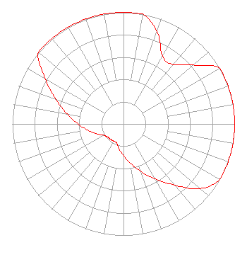 | ||||||||||||||||||
| Azimuth | Ratio | Azimuth | Ratio | Azimuth | Ratio | Azimuth | Ratio | ||||||||||||
| 0 | 1.000 | 10 | 1.000 | 20 | 0.881 | 30 | 0.700 | ||||||||||||
| 40 | 0.696 | 50 | 0.820 | 60 | 1.000 | 70 | 1.000 | ||||||||||||
| 80 | 1.000 | 90 | 1.000 | 100 | 1.000 | 110 | 1.000 | ||||||||||||
| 120 | 1.000 | 130 | 0.902 | 140 | 0.717 | 150 | 0.569 | ||||||||||||
| 160 | 0.452 | 170 | 0.359 | 180 | 0.285 | 190 | 0.227 | ||||||||||||
| 200 | 0.180 | 210 | 0.178 | 220 | 0.180 | 230 | 0.184 | ||||||||||||
| 240 | 0.205 | 250 | 0.258 | 260 | 0.325 | 270 | 0.409 | ||||||||||||
| 280 | 0.515 | 290 | 0.648 | 300 | 0.815 | 310 | 1.000 | ||||||||||||
| 320 | 1.000 | 330 | 1.000 | 340 | 1.000 | 350 | 1.000 | ||||||||||||
Structure Registration Number 1034328 Structure Type: TOWER Registered To: VB-S1 Assets, LLC Structure Address: 44 Orchard Hill Road Barrington, NH County Name: Strafford County ASR Issued: 04/04/2022 Date Built: 03/01/1990 Site Elevation: 115.8 m (380 ft.) Structure Height: 116.3 m (382 ft.) Height Overall: 117.3 m (385 ft.) Overall Height AMSL: 233.1 m (765 ft.) FAA Determination: 05/03/2011 FAA Study #: 2011-ANE-664-OE FAA Circular #: 70/7460-1J Paint & Light FAA Chapters: 3, 4, 5, 13 PRIOR STUDY 1998-ANE-86-OE 43-13-26.0 N 70-58-17.0 W (NAD 83) 43-13-25.7 N 70-58-18.8 W (Converted to NAD 27) |
P.o. Box 398 New Durham, NH 03855 Phone: 603-859-9170 Not-for-Profit | Title: Technical Consultant Date: 04/14/2021 Application Certifier WORD RADIO EDUCATIONAL FOUNDATION Word Radio Educational Foundation P.o. Box 398 New Durham, NH 03855 Applicant ROBERT MOORE Rcm Enterprises 1908 Sweetbriar Drive Goshen, IN 46528 CONSULTING ENGINEER MATTHEW H. MCCORMICK Fletcher, Heald & Hildreth, Plc 1300 North 17th Street 11th Floor Arlington, VA 22209 | |||||||||||||||||
|
| ||||||||||||||||||