
FCCInfo.com
A Service of Cavell, Mertz & Associates, Inc.
(855) FCC-INFO
|
|
K297BB from 05/26/2004 |
|
|
||||||||||||||||
|
|
K297BB Channel: 297D 107.3 MHz Edmond, Oklahoma Service: FX - A translator or application for a translator. Facility ID: 156917 Fac. Service: FX Programming Delivery Method: Unspecified Status: License Application Accepted: 04/16/2021 Application Granted: 05/18/2021 File Number: -0000143614 License Expires: 06/01/2021 Application Type: License To Cover FCC Website Links: LMS Facility Details This Application Other K297BB Applications Other K297BB Applications in CDBS Including Superseded Applications Mailing Address Correspondence for K297BB Correspondence related to application -0000143614 Service Contour - Open Street Map or USGS Map (60 dBu) Service Contour - KML / Google Earth (60 dBu) Facility Type: NON-COMMERCIAL EDUC. FM Class: D, A Noncommercial educational operating with no more than 10W Site Location: 35-34-18.2 N 97-29-09.1 W (NAD 83) Site Location: 35-34-18.0 N 97-29-08.0 W (Converted to NAD 27) Effective Radiated Power: 0.19 kW Antenna Center HAAT: 0 m Antenna Center AMSL: 612 m (2008 ft.) Antenna Center HAG: 250 m (820 ft.) Site Elevation: 362 m. (1188 ft.) Height Overall*: 258 m (846 ft.) (* As Filed In This Application, may differ from ASR Data, Below.) Directional Antenna Antenna Make/Model: Nicom BKG77-2 Antenna ID: 133665 Polarization:
| ||||||||||||||||||
| Antenna Data for Antenna Id: 133665 K297BB FX File: -0000143614 Nicom - BKG77-2 Service: FX Pattern and Field Values Include a 165° Clockwise Rotation | 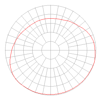 | ||||||||||||||||||
| Azimuth | Ratio | Azimuth | Ratio | Azimuth | Ratio | Azimuth | Ratio | ||||||||||||
| 5 | 0.702 | 15 | 0.712 | 25 | 0.732 | 35 | 0.772 | ||||||||||||
| 45 | 0.802 | 55 | 0.853 | 65 | 0.909 | 75 | 0.953 | ||||||||||||
| 85 | 0.973 | 95 | 0.983 | 105 | 1.000 | 115 | 0.992 | ||||||||||||
| 125 | 0.988 | 135 | 0.988 | 145 | 0.983 | 155 | 0.983 | ||||||||||||
| 165 | 0.983 | 175 | 0.983 | 185 | 0.983 | 195 | 0.988 | ||||||||||||
| 205 | 0.988 | 215 | 0.992 | 225 | 1.000 | 235 | 0.991 | ||||||||||||
| 245 | 0.963 | 255 | 0.923 | 265 | 0.873 | 275 | 0.832 | ||||||||||||
| 285 | 0.792 | 295 | 0.762 | 305 | 0.732 | 315 | 0.710 | ||||||||||||
| 325 | 0.702 | 335 | 0.702 | 345 | 0.702 | 355 | 0.702 | ||||||||||||
Structure Registration Number 1244114 Structure Type: TOWER Registered To: Vertical Bridge Towers III, LLC Structure Address: 1601 Ne 101st St Oklahoma City, OK County Name: Oklahoma County ASR Issued: 10/30/2019 Date Built: 07/13/2005 Site Elevation: 362.4 m (1189 ft.) Structure Height: 251.6 m (825 ft.) Height Overall: 257.6 m (845 ft.) Overall Height AMSL: 620 m (2034 ft.) FAA Determination: 02/18/2004 FAA Study #: 2004-ASW-377-OE FAA Circular #: 70/7460-1J Paint & Light FAA Chapters: 3, 4, 5, 13 OM&L to remain the same as prior study = PAINT/RED LIGHTS 35-34-18.4 N 97-29-09.0 W (NAD 83) 35-34-18.2 N 97-29-07.9 W (Converted to NAD 27) |
880 E 1545 Rd Calvin, OK 74531 Phone: 580-892-3753 Not-for-Profit | Title: President Date: 04/16/2021 Application Certifier RUSSELL MINISTRIES, INC Russell Ministries, Inc 880 E 1545 Rd Calvin, OK 74531 Applicant Mike Russell, Christy Russell Ministries, Inc. 880 E 1545 Rd Calvin, OK 74531 President Gene Wisniewski Genew2012 1472 E 3100 S Wendell, ID 83355 CONSULTING ENGINEER | |||||||||||||||||