
FCCInfo.com
A Service of Cavell, Mertz & Associates, Inc.
(855) FCC-INFO
|
|
KLTU from 02/29/1996 |
|
|
|||||||||||||||||
|
|
KLTU Channel: 201C0 88.1 MHz Mammoth, Arizona Service: FM - A full-service FM station or application. Facility ID: 79359 Fac. Service: FM Analog & Digital Status: License Application Accepted: 05/05/2021 Application Granted: 05/20/2021 File Number: -0000144607 License Expires: 10/01/2021 Application Type: License To Cover FCC Website Links: LMS Facility Details This Application Other KLTU Applications Other KLTU Applications in CDBS Including Superseded Applications Mailing Address Correspondence for KLTU Correspondence related to application -0000144607 Service Contour - Open Street Map or USGS Map (60 dBu) Service Contour - KML / Google Earth (60 dBu) Public Inspection Files Facility Type: NON-COMMERCIAL EDUC. FM Class: C0, C0 Site Location: 32-14-56.2 N 111-07-01.1 W (NAD 83) Site Location: 32-14-55.9 N 111-06-58.7 W (Converted to NAD 27) Effective Radiated Power: 16 kW Transmitter Output Power: 7.05 kW Antenna Center HAAT: 603 m (1978 ft.) Antenna Center AMSL: 1372 m (4501 ft.) Antenna Center HAG: 38 m (125 ft.) Site Elevation: 1334.1 m. (4377 ft.) Height Overall*: 60.1 m (197 ft.) (* As Filed In This Application, may differ from ASR Data, Below.) Directional Antenna Antenna Make/Model: Shively 6810-4-SS-DA Antenna ID: 94806 Polarization:
| |||||||||||||||||||
| Antenna Data for Antenna Id: 94806 KLTU FM File: -0000144607 Shively - 6810-4-SS-DA Service: FM | 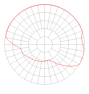 | |||||||||||||||||||
| Azimuth | Ratio | Azimuth | Ratio | Azimuth | Ratio | Azimuth | Ratio | |||||||||||||
| 0 | 1.000 | 10 | 1.000 | 20 | 1.000 | 30 | 1.000 | |||||||||||||
| 40 | 1.000 | 50 | 1.000 | 60 | 1.000 | 70 | 1.000 | |||||||||||||
| 80 | 0.940 | 90 | 0.960 | 100 | 1.000 | 110 | 1.000 | |||||||||||||
| 120 | 1.000 | 130 | 0.846 | 140 | 0.672 | 150 | 0.534 | |||||||||||||
| 160 | 0.424 | 170 | 0.409 | 180 | 0.421 | 190 | 0.438 | |||||||||||||
| 200 | 0.439 | 210 | 0.461 | 220 | 0.474 | 230 | 0.504 | |||||||||||||
| 240 | 0.552 | 250 | 0.591 | 260 | 0.609 | 270 | 0.767 | |||||||||||||
| 280 | 0.965 | 290 | 1.000 | 300 | 1.000 | 310 | 1.000 | |||||||||||||
| 320 | 1.000 | 330 | 1.000 | 340 | 1.000 | 350 | 1.000 | |||||||||||||
Structure Registration Number 1218220 Structure Type: GTOWER Registered To: American Towers LLC Structure Address: 7120 W. Lost Canyon Rd. (tucson Mtn, T5 #8171--dsm) Tucson, AZ County Name: Pima County ASR Issued: 09/01/2020 Date Built: 01/26/1998 Site Elevation: 1334.1 m (4377 ft.) Structure Height: 60.1 m (197 ft.) Height Overall: 60.1 m (197 ft.) Overall Height AMSL: 1394.2 m (4574 ft.) FAA Determination: 08/31/2020 FAA Study #: 2020-AWP-9090-OE Paint & Light FAA Chapters: NONE PRIOR STUDY 2011-AWP-6649-OE 32-14-56.2 N 111-07-01.1 W (NAD 83) 32-14-55.9 N 111-06-58.7 W (Converted to NAD 27) |
5700 West Oaks Blvd. Rocklin, CA 95765 Phone: 916-251-1600 Not-for-Profit | Title: Ceo Date: 05/05/2021 Application Certifier EDUCATIONAL MEDIA FOUNDATION Educational Media Foundation 5700 West Oaks Blvd. Rocklin, CA 95765 Applicant Mary O'Connor Wilkinson Barker Knauer, Llp 1800 M Street, N.w. Suite 800n Washington, DC 20036 James L Travis Educational Media Foundation 5700 West Oaks Blvd. Rocklin, CA 95765 | ||||||||||||||||||