
FCCInfo.com
A Service of Cavell, Mertz & Associates, Inc.
(855) FCC-INFO
|
|
|
|
|
||||||||||||||||
|
|
WYOR Channel: 203B1 88.5 MHz Republic, Ohio Service: FM - A full-service FM station or application. Facility ID: 174213 Fac. Service: FM Status: Construction Permit Application Accepted: 05/24/2021 Application Granted: 03/31/2022 File Number: -0000146842 WYOR CP Expires: 03/31/2025 Application Type: Minor Modification FCC Website Links: LMS Facility Details This Application Other WYOR Applications Other WYOR Applications in CDBS Including Superseded Applications Mailing Address Correspondence for WYOR Correspondence related to application -0000146842 Service Contour - Open Street Map or USGS Map (60 dBu) Service Contour - KML / Google Earth (60 dBu) Public Inspection Files Facility Type: NON-COMMERCIAL EDUC. FM Class: B1, A Zone I or I-A station; with 6kW-25kW ERP and a class contour distance 28km-39km Site Location: 41-14-55.8 N 82-54-45.9 W (NAD 83) Site Location: 41-14-55.6 N 82-54-46.2 W (Converted to NAD 27) Effective Radiated Power: 20 kW Antenna Center HAAT: 85 m (279 ft.) Antenna Center AMSL: 322 m (1056 ft.) Antenna Center HAG: 81 m (266 ft.) Site Elevation: 240.8 m. (790 ft.) Height Overall*: 91.1 m (299 ft.) (* As Filed In This Application, may differ from ASR Data, Below.) Directional Antenna Antenna Make/Model: None Antenna ID: 1006063 Polarization: | ||||||||||||||||||
| Antenna Data for Antenna Id: 1006063 WYOR FM File: -0000146842 None - Service: FM | 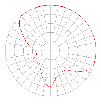 | ||||||||||||||||||
| Azimuth | Ratio | Azimuth | Ratio | Azimuth | Ratio | Azimuth | Ratio | ||||||||||||
| 0 | 1.000 | 10 | 1.000 | 20 | 1.000 | 30 | 1.000 | ||||||||||||
| 40 | 1.000 | 50 | 1.000 | 60 | 1.000 | 70 | 1.000 | ||||||||||||
| 80 | 1.000 | 90 | 1.000 | 100 | 1.000 | 110 | 1.000 | ||||||||||||
| 120 | 0.888 | 130 | 0.705 | 140 | 0.560 | 150 | 0.529 | ||||||||||||
| 160 | 0.560 | 170 | 0.628 | 180 | 0.792 | 190 | 0.710 | ||||||||||||
| 200 | 0.565 | 210 | 0.448 | 220 | 0.378 | 225 | 0.378 | ||||||||||||
| 230 | 0.400 | 240 | 0.448 | 250 | 0.356 | 255 | 0.317 | ||||||||||||
| 260 | 0.317 | 270 | 0.356 | 280 | 0.448 | 290 | 0.565 | ||||||||||||
| 300 | 0.710 | 310 | 0.894 | 320 | 1.000 | 330 | 1.000 | ||||||||||||
| 340 | 1.000 | 350 | 1.000 | ||||||||||||||||
Structure Registration Number 1027715 Structure Type: GTOWER Registered To: BAS Broadcasting, Inc Structure Address: 13318 E Cr 62 Hwy Bellevue, OH County Name: Seneca County ASR Issued: 07/11/2017 Date Built: 04/24/2017 Site Elevation: 240.8 m (790 ft.) Structure Height: 90.3 m (296 ft.) Height Overall: 91.1 m (299 ft.) Overall Height AMSL: 331.9 m (1089 ft.) FAA Determination: 06/01/2017 FAA Study #: 2017-AGL-7595-OE FAA Circular #: 70/7460-1L Paint & Light FAA Chapters: 3, 4, 5, 12 PRIOR STUDY 2004-AGL-7744-OE 41-14-55.8 N 82-54-45.9 W (NAD 83) 41-14-55.6 N 82-54-46.2 W (Converted to NAD 27) |
172 N Cedar St Imlay City, MI 48444 Phone: 810-895-2040 Not-for-Profit | Title: President Date: 05/24/2021 Application Certifier SMILE FM Smile Fm 172 N Cedar St Imlay City, MI 48444 Applicant EDWARD CZELADA Smile Fm 3302 N. Van Dyke Rd. Imlay City, MI 48444 PRESIDENT | |||||||||||||||||