
FCCInfo.com
A Service of Cavell, Mertz & Associates, Inc.
(855) FCC-INFO
|
|
|
|
|
||||||||||||||||
|
|
W293AB Channel: 293D 106.5 MHz Keene, New Hampshire Service: FX - A translator or application for a translator. Facility ID: 17796 Fac. Service: FX Programming Delivery Method: Unspecified Status: License Application Accepted: 06/22/2021 Application Granted: 07/30/2021 File Number: -0000150683 License Expires: 04/01/2022 Application Type: License To Cover FCC Website Links: LMS Facility Details This Application Other W293AB Applications Other W293AB Applications in CDBS Including Superseded Applications Mailing Address Correspondence for W293AB Correspondence related to application -0000150683 Service Contour - Open Street Map or USGS Map (60 dBu) Service Contour - KML / Google Earth (60 dBu) Facility Type: FM STATION Class: D, A Noncommercial educational operating with no more than 10W Site Location: 42-54-57.3 N 72-19-50.3 W (NAD 83) Site Location: 42-54-57.0 N 72-19-52.0 W (Converted to NAD 27) Effective Radiated Power: 0.15 kW Antenna Center HAAT: 0 m Antenna Center AMSL: 422 m (1385 ft.) Antenna Center HAG: 19 m (62 ft.) Site Elevation: 403 m. (1322 ft.) Height Overall*: 27 m (89 ft.) (* As Filed In This Application, may differ from ASR Data, Below.) Directional Antenna Antenna Make/Model: Scala CA5-RM/CP/RM Antenna ID: 16149 Polarization: H
| ||||||||||||||||||
| Antenna Data for Antenna Id: 16149 W293AB FX File: -0000150683 Scala - CA5-RM/CP/RM Service: FX Pattern and Field Values Include a 80° Clockwise Rotation | 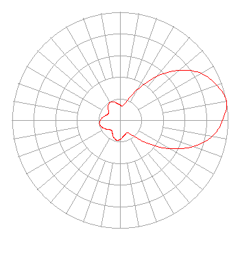 | ||||||||||||||||||
| Azimuth | Ratio | Azimuth | Ratio | Azimuth | Ratio | Azimuth | Ratio | ||||||||||||
| 0 | 0.142 | 10 | 0.134 | 20 | 0.190 | 30 | 0.329 | ||||||||||||
| 40 | 0.528 | 50 | 0.718 | 60 | 0.866 | 70 | 0.952 | ||||||||||||
| 80 | 1.000 | 90 | 0.952 | 100 | 0.866 | 110 | 0.718 | ||||||||||||
| 120 | 0.528 | 130 | 0.329 | 140 | 0.190 | 150 | 0.134 | ||||||||||||
| 160 | 0.142 | 170 | 0.157 | 180 | 0.181 | 190 | 0.187 | ||||||||||||
| 200 | 0.171 | 210 | 0.140 | 220 | 0.123 | 230 | 0.135 | ||||||||||||
| 240 | 0.160 | 250 | 0.182 | 260 | 0.193 | 270 | 0.182 | ||||||||||||
| 280 | 0.160 | 290 | 0.135 | 300 | 0.123 | 310 | 0.140 | ||||||||||||
| 320 | 0.171 | 330 | 0.187 | 340 | 0.181 | 350 | 0.157 | ||||||||||||
Structure Registration Number 1258968 Structure Type: TOWER Registered To: HEW Communications, Inc Structure Address: Atop West Hill Keene, NH County Name: Cheshire County ASR Issued: 06/25/2007 Date Built: 09/10/2008 Site Elevation: 403 m (1322 ft.) Structure Height: 26.8 m (88 ft.) Height Overall: 26.8 m (88 ft.) Overall Height AMSL: 429.8 m (1410 ft.) FAA Determination: 06/15/2007 FAA Study #: 2007-ANE-1022-OE Paint & Light FAA Chapters: NONE Removed expiration date from determination. Scenario 1./jjs/case#635066 42-54-57.3 N 72-19-50.3 W (NAD 83) 42-54-57.0 N 72-19-52.0 W (Converted to NAD 27) |
106 North Main Street West Lebanon, NH 03766 Phone: 603-359-7110 Limited Liability Company | Title: Managing Member Date: 06/22/2021 Application Certifier GREAT EASTERN RADIO, LLC Great Eastern Radio, Llc 35 South Main Street Suite 300 Hanover, NH 03755 Applicant ROBERT M Smith, Jr R.m. Smith Associates 10920b Crown Colony Drive Austin, TX 78747 TECHNICAL CONSULTANT David G O'Neil Rini O'neil, Pc 2101 L Street, Nw Suite 300 Washington, DC 20037 Esq | |||||||||||||||||