
FCCInfo.com
A Service of Cavell, Mertz & Associates, Inc.
(855) FCC-INFO
|
|
K250AB from 02/09/1989 |
|
|
||||||||||||||||
|
|
K250AB Channel: 250D 97.9 MHz Roswell, New Mexico Service: FX - A translator or application for a translator. Facility ID: 10924 Fac. Service: FX Programming Delivery Method: Unspecified Status: License Application Accepted: 07/16/2021 Application Granted: 02/11/2022 File Number: -0000153215 License Expires: 10/01/2029 Application Type: License To Cover FCC Website Links: LMS Facility Details This Application Other K250AB Applications Other K250AB Applications in CDBS Including Superseded Applications Mailing Address Correspondence for K250AB Correspondence related to application -0000153215 Service Contour - Open Street Map or USGS Map (60 dBu) Service Contour - KML / Google Earth (60 dBu) Facility Type: NON-COMMERCIAL EDUC. FM Class: D, A Noncommercial educational operating with no more than 10W Site Location: 33-23-36.2 N 104-37-28.5 W (NAD 83) Site Location: 33-23-35.8 N 104-37-26.6 W (Converted to NAD 27) Effective Radiated Power: 0.205 kW Transmitter Output Power: 0.009 kW Antenna Center HAAT: 0 m Horiz.; 42.5 m Vert. Antenna Center AMSL: 1201.7 m (3943 ft.) Antenna Center HAG: 27 m (89 ft.) Site Elevation: 1174.7 m. (3854 ft.) Height Overall*: 60.6 m (199 ft.) (* As Filed In This Application, may differ from ASR Data, Below.) Directional Antenna Antenna Make/Model: Nicom BKG77R-2 Antenna ID: 76604 Polarization: H
| ||||||||||||||||||
| Antenna Data for Antenna Id: 76604 K250AB FX File: -0000153215 Nicom - BKG77R-2 Service: FX | 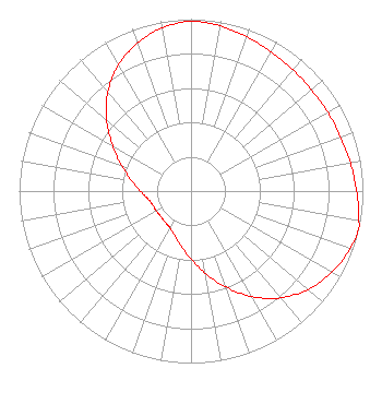 | ||||||||||||||||||
| Azimuth | Ratio | Azimuth | Ratio | Azimuth | Ratio | Azimuth | Ratio | ||||||||||||
| 0 | 0.987 | 10 | 0.976 | 20 | 0.954 | 30 | 0.934 | ||||||||||||
| 40 | 0.922 | 50 | 0.915 | 60 | 0.918 | 70 | 0.925 | ||||||||||||
| 80 | 0.942 | 90 | 0.963 | 100 | 0.991 | 103 | 1.000 | ||||||||||||
| 110 | 0.984 | 120 | 0.945 | 130 | 0.890 | 140 | 0.810 | ||||||||||||
| 150 | 0.709 | 160 | 0.594 | 170 | 0.486 | 180 | 0.395 | ||||||||||||
| 190 | 0.326 | 200 | 0.275 | 210 | 0.246 | 220 | 0.235 | ||||||||||||
| 230 | 0.230 | 240 | 0.232 | 250 | 0.237 | 260 | 0.255 | ||||||||||||
| 270 | 0.294 | 280 | 0.351 | 290 | 0.429 | 300 | 0.527 | ||||||||||||
| 310 | 0.642 | 320 | 0.752 | 330 | 0.846 | 340 | 0.914 | ||||||||||||
| 350 | 0.964 | ||||||||||||||||||
Structure Registration Number 1022467 Structure Type: TOWER Registered To: American Towers LLC Structure Address: Junction Of Hwy. 70 And 380 Roswell, NM County Name: Chaves County ASR Issued: 01/05/2021 Date Built: 11/01/1991 Site Elevation: 1174.7 m (3854 ft.) Structure Height: 58.2 m (191 ft.) Height Overall: 60.6 m (199 ft.) Overall Height AMSL: 1235.3 m (4053 ft.) FAA Determination: 06/05/2002 FAA Study #: 02-ASW-2144-OE Paint & Light FAA Chapters: NONE PRIOR STUDY 98-ASW-5111-OE 33-23-36.2 N 104-37-28.5 W (NAD 83) 33-23-35.8 N 104-37-26.6 W (Converted to NAD 27) |
3434 W. Kilbourn Ave. Milwaukee, WI 53208 Phone: 414-935-3000 Not-for-Profit | Title: Vice President Of Communications Date: 07/16/2021 Application Certifier VCY AMERICA, INC. Vcy America, Inc. 3434 W. Kilbourn Ave. Milwaukee, WI 53208 Applicant Kathryne Dickerson, Esq Wiley Rein Llp 1776 K Street, N.w. Washington, DC 20006 | |||||||||||||||||